|
|
 [Image: Cincinnati Public Library, 1870s; photo via Steve Silberman]. [Image: Cincinnati Public Library, 1870s; photo via Steve Silberman].
It's that time of the year again, to take a look at the many, many books that have passed through the halls of BLDGBLOG the past season or two, ranging, as usual, from popular science to fiction, landscape history to the urban future of the refugee camp.
There are some great books included in this round-up, ones I'd love to help find a wider audience—however, as will be clear from a handful of descriptions below, and as is always the case with book round-ups here on BLDGBLOG, I have not read every book included in the following list and not all of them are necessarily new.
However, in all cases, these books are included for the interest of their approach or for their general subject matter, and the wide range of themes present should give anyone at least a few interesting titles to seek out for autumn reading.
 1) Exploding the Phone: The Untold Story of the Teenagers and Outlaws Who Hacked Ma Bell
 by Phil Lapsley (Grove Press)
One of the most enjoyable books of my summer was Exploding the Phone by Phil Lapsley. Lapsley’s history of “phone phreaks,” or people who successfully hacked the early phone networks into giving them free calls to one another and around the world, would read, in a different context, like some strange occult thriller featuring disaffected teenagers tapping into a supernatural world. Weird boxes, unexplained dial tones, and disembodied voices at the end of the line pop up throughout the book, as do surprise cameos from a pre-Apple Steve Wozniak and Steve Jobs.
Teenagers throwing frequencies and sounds at vast machines through telephone handsets managed to unlock another dimension of the phone network, Lapsley explains, a byzantine geography of remote switching centers and international operators. In the process, they helped pave the way for the hackers we know today. I have heard, anecdotally, from a few people who were around and part of these groups at the time, that Lapsley got some of his details wrong, but that didn’t take away from my enjoyment of—or inability to put down—his book. Recommended, and very fun.
2) Robot Futures by Illah Reza Nourbakhsh (MIT Press)
This pamphlet-length book by Carnegie Mellon University’s Illah Reza Nourbakhsh on the future of robotics pays admirable attention to the fundamental problem of even defining what “robotics” is. Better yet, Nourbakhsh prefaces each of his short chapters with fictional interludes exploring speculative scenarios of future robotics gone awry. There is a disturbing vignette in which flying robot toys programmed to recognize human eye contact swarm around and terrify anyone not hiding their gaze behind wearing sunglasses—something the toys’ manufacturer never predicted—as well as a memorable scenario in which new forms of robot-readable graffiti throw entire self-driving traffic systems into a tizzy, making car after car wrongly report that an impenetrable roadblock lies ahead. Call it traffic-hacking.
In the end, Nourbakhsh suggests, robots will prove to be fundamentally different from human beings, and we should be prepared for his. “A robot moving down the street will see in all directions, not simply in front of it like humans,” he writes. “If that robot is connected to a network of video cameras along the street, it will see everywhere on the street, from all angles, the entire time it walks. Imagine this scenario. A not-very-clever robot walking down the street will have access to entire synthesized views of the street—up and down, behind you, down the alley, around the corner—and be able to scroll back through time with perfect fidelity. As you approach this robot, it might be cognitively much dumber than you, but it knows far more about its surroundings than you do. It stops suddenly. What do you do? There is no common ground established between you and this robot, just the fact that you occupy the same sidewalk.”
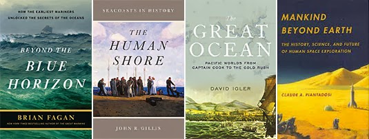 3) Beyond The Blue Horizon: How The Earliest Mariners Unlocked The Secrets Of The Oceans
 by Brian Fagan (Bloomsbury Press)
Brian Fagan, an environmental historian known for his books on climate change and civilization, has written a great example of what might be called adventure-history. Beyond the Blue Horizon takes us through roughly twenty thousand—even potentially, depending on how you interpret the archaeological evidence, more than one hundred thousand—years of human seafaring. Every few pages, amidst tales of people sailing in small groups, even drifting, seemingly lost, for days at a time across vast expanses of open water, Fagan makes arresting observations, such as the fact that early Pacific navigators, laden down with seeds and plants, “literally carried their own landscape with them,” he writes.
The importance of the coast in supporting human settlement, and the absolute centrality of the sea—rather than continental interiors—in shaping human history, gives Fagan multiple opportunities to refocus our sense of our own remote past. We are not landed creatures of roads and automobiles, Fagan argues, but a maritime species whose entire childhood and adolescence was spent paddling past unknown coastlines, searching for freshwater rivers and streams—a “world of ceaseless movement,” as he calls it, including now lost islands, deltas, and coasts. Fagan’s brilliance at describing landscapes as they undergo both seasonal changes and variations in climate also applies to his depictions of Earthly geography when sea levels were, for most of the eras described in his book, more than 300 feet lower than it is today. It was another planet—a maritime world—one that humans seem to have lost sight of and forgotten.
4) The Human Shore: Seacoasts in History by John R. Gillis (University of Chicago Press)
John R. Gillis’s look at “seacoasts in history” proves to be compulsively readable, sustaining many long subway rides for me here in New York, although the final few chapters fall off into unnecessarily long quotations from what seems like any random academic source he could find that mentioned the sea. This is too bad, because a shorter, more tightly edited version of this book would be a dream. Gillis is not shy about making outsized claims for revising the history of human civilization. The shore is “the true home of humankind,” he writes, “the original Eden.” He wants Westerners to forget the “terracentric history” they’ve been taught, which is, he points out, simply a historical misunderstanding of where humans actually spent 95%—the number Gillis uses—of their development: on shorelines and coastal islands.
“The book of Genesis would have us believe that our beginnings were wholly landlocked,” he writes, “but it was written at the time that the Hebrews were settling down to an agrarian existence.” Gillis quotes the words of writer Steve Mentz here, who argued that we need “fewer gardens, and more shipwrecks” in our narrative understanding of human prehistory.
Gillis allows his book some intriguing political subthemes. He writes, for example, that “it would be a very long time, almost three hundred years, before Europeans realized the full extent of the Americas’ continental character and grasped the fact that they might have to abandon the ways of seaborne empires for those of territorial states.” He adds, “for the first century or more [of their habitation in the Americas], northern Europeans showed more interest in navigational rights to certain waterways and sea tenures than in territorial possession as such.” Rivers and lakes were the key to ruling North America, for a time; and, seemingly since the interior land rush of U.S. history, the “seaborne” ways of humans, with or without a state to back them, have been forgotten.
As a brief side note, it’s interesting here to look at the Somali pirates so often mythologized in Western media, including the forthcoming Paul Greengrass film Captain Phillips—that stateless, seaborne groups of humans still exist and are the rogue scourge of landed empires (see also The Enemy of All by Daniel Heller-Roazan, etc.).
5) The Great Ocean: Pacific Worlds from Captain Cook to the Gold Rush by Davig Igler (Oxford University Press)
David Igler’s own book on all things anthropologically oceanic focuses solely on the Pacific Ocean, from the first wave of European exploration to early-modern sea trade. Igler, too, finds the land-locked nature of traditional history both claustrophobic and incorrect. “The ‘places’ usually subjected to historical analysis—nations, regions, and localities—have fixed borders enclosing land and thus constitute terrestrial history,” he writes in the book’s introduction. “Historians have far less experience imagining the ways that oceanic space connects people and polities, rather than separating them.” Igler’s larger point—that tides, currents, and winds, even specific ships, are also, in a sense, “places” deserving of historical recognition—animates the rest of the book.
Mankind Beyond Earth: The History, Science, And Future Of Human Space Exploration by Claude A. Piantadosi (Columbia University Press)
6) This book is admittedly quite hampered by its extraordinary practicality: there is very little poetry here, mostly straight talk of musculoskeletal disorders in low gravity and heat-loss from warm bodies in space. We begin on the ground floor, not only with a short and perhaps unnecessary history of the U.S. space program, but with the very basics of human physiology and the mechanics of flight. I suspect, however, that most readers are perfectly willing to jump into the deep end and read what’s on offer in the book’s later chapters: human visits to Mars, to asteroids, to “big planets, dwarf planets, and small bodies,” in Piantadosi’s words, to the “moons of the ice giants” and beyond. Ultimately, though, the book is simply too dry to feel like these later glimpses of “mankind beyond Earth,” as the title teasingly—and, for the most part, misleadingly—promises, are a worthy reward. If you must, one to look for in the local library.
 7) Scatter, Adapt, and Remember: How Humans Will Survive a Mass Extinction
 by Annalee Newitz (Doubleday)
Annalee Newitz, editor-in-chief of io9 and thus, now, a colleague of mine, has exceeded all expectations with the research, depth, and range of this quirkily enthusiastic look at planetary mass extinction. Her early chapters on dinosaurs, plagues, extremophiles, world-altering volcanic eruptions, long geological eras when the Earth was locked in ice, possible human/Neanderthal guerrilla warfare (not to mention inter-breeding), and much more, are like a New Scientist article you hope never ends. It’s an exciting read.
Oddly, though, the central premise of the book—that, through urbanization, human beings will find ways to avoid their own extinction—feels tacked on and unconvincingly developed. If I’m being honest, it feels like Newitz is trying to make more of an ideological point about the political value and cultural centrality of cities today, rather than actually arguing rationally for the possibility that cities will save the human species. This is especially the case if we’re talking about—as, in this book, we are—catastrophic asteroid impacts or the outbreak of a super-virus. This otherwise gripping book thus has a bit of an are-you-serious? feel as it wraps up its final fifty pages or so. While advancing a theory of safety achieved through collective living, urban farming, and social cooperation, Newitz also inadvertently seems to contradict the first command of her book’s title: to scatter. That is, to fling ourselves to the far edges of the universe—to explore, survive, and mutate with the cosmos—not to band together, urbanize, and cooperate.
As such, it seems possible to imagine an identical version of this book—identical, that is, for 200 pages or so—but with a radically differnet ending: one in which truly scattering, adapting ourselves, isolating ourselves, and differentiating our civilizational pursuits—even differentiating our very DNA through evolution in separation—would be the most effective way to avoid human extinction. But that argument, it seems, is ideologically impermissible; it makes you an anti-state survivalist, a cosmic redneck, building bunkers in the Utah desert or on the moons of another world, more Ted Nugent than Stewart Brand.
In any case, putting political arguments like these aside, the book ends with a mind-popper of a quotation. In a conversation with Randii Wessen at the Jet Propulsion Lab in Pasadena, California, Wessen tells Newitz: “Our kids are the last generation who will see no city lights on the Moon.” This is both wonderful and terrible, and as concise a statement as I’ve read anywhere to show the human future rolling on.
8) Five Billion Years of Solitude: The Search for Life Among the Stars by Lee Billings (Current)
Gifted science writer Lee Billings takes us on a search for other Earths—or, more accurately, for habitable “exoplanets” where life like us may or may not have a chance of existing. The book starts off with quite a coup. Billings treats us to a long, at-home visit with astronomer Frank Drake of Drake’s Equation fame: the abstract but reasonable calculation used for decades now to determine whether or not intelligent civilizations might exist elsewhere (and, by extension, how likely it is that humans will find them).
The book is not hard science, it is easy to follow, and Billings is a great writer; his tendency, however, veers toward the humanistic, following the life stories of individual astronomers or physicists here on Earth as they search the outer reaches of the detectable universe for signs of exoplanets.
A sizable diversion late in the book, for example, takes us on a canoe trip far into the Canadian north, past lakes and rivers, with a wary eye on approaching storms, to tell the story of how physicist Sara Seager met and fell in love with one of her colleagues. It is not a short diversion, and you’d be forgiven for thinking that Seager’s canoe trip has little to do with the search for “life among the stars,” as the book’s subtitle suggests. It is at moments like this, as Seager and her partner paddle from one portage to another, that I found myself wondering if the only stories to tell are of other human beings—whether scientists or NASA administrators—then why, in a sense, are we looking for exoplanets at all?
Of course, the book jacket never promised us surreal descriptions of other worlds. But it’s hard not to hope for exactly that: that Billings would focus his considerable rhetorical powers away from our world for a few more chapters and offer those evocative glimpses of Earth-like planets I suspect so many readers will come to his book to find—visions of worlds like ours but magically, cosmically different—and thus communicate the beautiful, poetically irresistible urge to discover them. His introductory descriptions of the formation of our solar system, for instance, are breathtaking, clear, and poetic, and similar passages elsewhere show the pull of the exoplanetary; the narrative structure of the scientist profile seems inadvertently to have focused the bulk of the book's attention here on Earth, where we are already bound, rather than to let the strange light of the universe shine through more frequently.
But this is like complaining about dessert after a delicious meal. I’ll simply hope that Billings’s next book concentrates more on the inhuman allure so peculiar to astronomy, a field astonishingly rich with worlds mortal humans long to see.
9) Are We Being Watched?: The Search for Life in the Cosmos by Paul Murdin (Thames & Hudson)
The off-putting and sensationalistic title of Paul Murdin’s new book is, thankfully, not a sign of things to come in the text itself. Murdin’s sober yet thrilling look at the history and future of astrobiology is a bright spot in a recent spate of books about the possibility of extraterrestrial life. “The twenty-first century is the century of astrobiology,” he writes in the first sentence of chapter one; indeed, he adds with extraordinary confidence, “this is the era in which we will discover life on other worlds, and learn from it.”
Amidst many interesting tidbits, one worth repeating here actually comes from Murdin’s quotation of paleontologist Simon Conway-Morris. Conway-Morris, referring to the possibility of discovering truly alien life, rightly suggests that we could very well have no idea what we’re looking at. Indeed, he memorably says, these other life forms could be “constructions so unfamiliar that they are only brought home by accident and then inadvertently handed over for curation in a department of mineralogy.” The idea that rocks sitting quietly in a Natural History museum somewhere are actually alien life forms is mind-blowing and but one take-away from this thought-provoking book.
Over the course of Are We Being Watched?, Murdin enjoyably goes all over the place, from amino acids to plate tectonics, to radio-stimulated organic molecules in the atmosphere of Titan. As if channeling H.P. Lovecraft, Murdin at one point writes that, on Jupiter’s ice-covered moon Europa, scientists have seen the same churning processes as witnessed in Antarctica, but, on Europa, “we see the results of this churning as colored stains on ridges of ice at the boundaries of ice floes. Perhaps in these colored stains lie dead creatures, brought up from the depths of the ocean and exposed to view by orbiting spacecraft or landers that can rove over the surface.”
10) Frankenstein's Cat: Cuddling Up to Biotech's Brave New Beasts by Emily Anthes (FSG)
Frankenstein’s Cat follows the 21st-century quest to re-engineer biology, to design “the fauna of the future,” as the book promises, or “biotech’s brave new beasts,” where resurrected species, pets with prostheses, and militarized insects crawl through forests of genetically modified trees. At once terrifying and thrilling, and animated in all cases by the gonzo enthusiasm of any science operating at seemingly unstoppable speed, Emily Anthes’s book shows the weird biological breakthroughs that will ultimately create the landscapes of tomorrow: the cities, gardens, parks, oceans, and backyards our descendants will inevitably mistake for nature (and then, eventually, dismiss as mundane).
 11) Sweet & Salt: Water And The Dutch
 by Tracy Metz and Maartje van den Heuvel (NAi Publishers)
Journalist Tracy Metz and art historian Maartje van den Heuvel have teamed up for this collaborative look at “environmental planning” in the Netherlands, with a focus on all things aquatic. While Metz visits the country’s numerous megaprojects and anti-flooding infrastructure to speak with water engineers, “dike wardens,” and other stewards of Holland’s relationship with rain and the sea, van den Heuvel assembles a spectacular catalog featuring visual depictions of waterworks throughout Dutch art history. This is “the visualization of water in art,” as she calls it, revealing “anxieties about flooding” and a deep-rooted infrastructural patriotism inspired by the technical means for controlling that flooding.
Ultimately, the book’s goal is to show how Dutch water management is changing in the face of rising sea levels and climate change, and how “water is coming back into the city,” as Metz writes, changing the nature of contemporary urban design.
12) Dutch New Worlds: Scenarios in Physical Planning and Design in the Netherlands, 1970-2000 by Christian Salewski (010 Publishers)
This well-illustrated history and catalog of large-scale hydrological projects in the Netherlands—and the “Dutch new worlds” those projects helped generate—offers a provocative look at the very idea of infrastructure. Salewski suggests that a nation’s infrastructure is like literature or mythology, a built narrative in which a much larger constellation of dreams and aspirations can be read. “There is no Dutch Hollywood,” Salewski writes, “no cinematic dream machine that constantly processes the current view of the future into easily digestible, mass-consumed science fiction movies. Dutch views into the future are probably best found not in cultural works of literature and art, but in physical planning designs.” That is, in the dams, dikes, levees, and polders the rest of the book goes on to so interestingly describe. Infrastructure, Salewski offers, is one of many ways in which a nation dreams.
13) Bird On Fire: Lessons From The World's Least Sustainable City by Andrew Ross (Oxford University Press)
Andrew Ross takes a critical look at Phoenix, Arizona, a desert city "sprawling over a thousand square miles, with a population of four and a half million, minimal rainfall, scorching heat, and an insatiable appetite for unrestrained growth and unrestricted property rights." As the city tries to "green" itself through boosts in public transportation and a more sensible water management strategy—among other things—Ross asks if an urban transformation, something that might save Phoenix from its current parched fate, is even possible.
14) Plutopia: Nuclear Families, Atomic Cities, and the Great Soviet and American Plutonium Disasters by Kate Brown (Oxford University Press)
Kate Brown’s Plutopia creates a horrifying set of conjoined urban twins, so to speak, by both comparing and contrasting the purpose-built plutonium production towns of Richland, Washington, and Ozersk, Russia. These were fully planned and state-supported facilities, yet both were also highly delicate, secret cities—in Ozersk’s case, literally off the map—constantly at risk of nuclear disaster. And disaster, of course, eventually comes.
Brown points out how, between the two of them, Richland and Ozersk released four times the amount of radiation into the environment as the meltdown at Chernobyl, and she tracks the disturbing long-term health and environmental effects in the surrounding regions. In both cases, perhaps cynically, perhaps inspiringly, these polluted regions have become nature reserves.
In a particularly troubling anecdote from the final chapter, referring to the experience of Richland, Brown points out that “periodically deer and rabbits wander from the preserve and leave radioactive droppings on Richland’s lawns,” but also, more seriously, that multiple wineries have sprung up perilously close to the hazard zone, “near the mothballed plutonium plant.” While sipping wine at one of those very vineyards, Brown tries to talk to the locals about the potential for radiation in the soil—and, thus, in the wine—but, unsurprisingly, they react to her questions “testily.”
These carefully manicured utopian towns, like scenes from The Truman Show crossed with Silkwood, with their dark role in the state production of plutonium, give us the “Plutopia” of the book’s title. Ozersk and Richland are “citadels of plutonium,” she writes, instant cities of the atomic age.
 15) From Camp To City: Refugee Camps of the Western Sahara
 by Manuel Herz (Lars Müller Publishers)
Based on original research from a studio taught at the ETH in Zurich, architect Manuel Herz has assembled this fascinating and important guide to the urban and quasi-urban structures of refugee camps. Focusing specifically on camps in extreme southwest Algeria, populated by people fleeing from conflict in the Western Sahara, these camps are, Herz suggests, Western instant urbanism stripped bare, the city shown at its factory presets, revealing the infrastructural defaults and basic political conditions of the modern metropolis. They are “the spatial manifestation of the state of exception,” he writes, citing Giorgio Agamben, mere “holding areas” in which urban forms slowly take shape and crystallize. The camps are where, Herz writes, “Architecture and planning becomes [sic] a replacement for a political solution.”
From the architecture of the tents themselves to the delivery infrastructures that bring water, food, and other vital goods to their inhabitants, to culturally specific spatial accouterments, like carpets and curtains, Herz shows how the camps manage to become cities almost in spite of themselves, and how these cities then offer something like training grounds for future nations to come. In Herz’s own words, “the camps act also as a training phase, during which the Sahrawi society [of the Western Sahara] can develop ideas and concepts of what system of education they want to establish, and learn about public health and medical service provision. The camps become a space where nation-building can be learned and performed, to be later transferred to their original homeland, if it becomes available in the future.”
This idea of the state-in-waiting—and its ongoing spatial rehearsal in the form of emergency camps—runs throughout the book, which is also a detailed, full-color catalog of almost every conceivable spatial detail of life in these refugee camps. In the process, Herz and his team have assembled a highly readable and deeply fascinating look at urbanism in its most exposed or raw condition. “In the blazing sun of the Sahara Desert,” he concludes, “we can observe the birth of the urban condition with a clarity and crispness almost unlike anywhere else in the world.”
16) Roman Disasters by Jerry Toner (Polity)
Cambridge Classicist Jerry Toner had described his wide range of interests as being centered on the notion of “history from below.” He has written prolifically about ancient Rome, in particular, from several unexpected points of view, including popular culture in antiquity, the smellscape of early Christianity, and an currently in-progress work on crime in the ancient metropolis.
Roman Disasters looks specifically at imperial disaster-response, including earthquakes, volcanic eruptions, catastrophic fires, warfare, and disease. Toner describes how the abstract notion of risk was first formulated and understood; the role of religious prophecy in “imagining future disaster”; and halting, ultimately unsuccessful attempts to construct a fireproof metropolis, such as the widening of city streets and the creation of a semi-permanent Roman fire brigade.
Very much a history, rather than a page-turner directed at a popular audience, Roman Disasters nonetheless offers a compelling and unexpected look at the ancient world, one peppered with refugee camps, tent cities, and displaced populations all looking for—and not necessarily finding—imperial beneficence.
17) Picking Up: On the Streets and Behind the Trucks with the Sanitation Workers of New York City by Robin Nagle (FSG)
Robin Nagle is an “anthropologist-in-residence” at the NYC Department Sanitation. Picking Up is her document of that incredible—and strange—backstage pass to the afterlife of the city, where all that we discard or undervalue simply gets tossed to the curb. Nagle tags along with, interviews, and reveals the “garbage faeries” who rid our streets of the unwanted detritus of everyday life, whether trash or snow. In the process, she’s written a kind of narrative map or oral history of another New York, one with its own flows and infrastructure, and one that exists all but invisibly alongside the one we inhabit everyday.
18) Factory Towns of South China: An Illustrated Guidebook edited by Stefan Al (Hong Kong University Press)
Architect Stefan Al, currently teaching at the University of Pennsylvania, leads a team of researchers to the Pearl River Delta, the “factory of the world,” to explore how people live and—even more—how they work in the region. A fascinating glimpse at the “self-contained world” of what amounts to corporate-industrial urbanism, the book nonetheless feels very much like a book assembled by architects who had a grant for producing a publication: it is heavy on comparative infographics, layered images, pie charts, and small-print introductory essays, all on coated paper resistant to underlining. The subject matter is fascinating, but the book is ultimately of less use than, say, sending Robin Nagle to visit these “factory towns of south China,” reporting back about the complicated lives and material cultures found there.
 19) Ruin Nation: Destruction And The American Civil War
 by Megan Kate Nelson (University of Georgia Press)
Megan Kate Nelson’s Ruin Nation is a kind of Piranesian guide to the Civil War ruins of American cities of the 19th century. The book is a bit slow and overly cautious in its descriptions, but it is remarkable for a specific focus on architectural ruins following the Civil War. “Architectural ruins—cities and houses—dominated the stories that soldiers and civilians told about the Civil War,” she writes in the book’s introduction, a time when whole cities were reduced to “lone chimneys” amidst the smoke and obliteration of urban warfare. We often hear—especially post-9/11—that Americans have never really experienced war and destruction on their own soil, but Nelson’s book convincingly and devastatingly shows how inaccurate a statement that is.
20) Line In The Sand: A History Of The U.S.-Mexico Border by Rachel St. John (Princeton University Press)
Heading west from the Gulf Coast, the U.S.-Mexico border takes an unexpected turn when you get past El Paso, Texas—that is, by not really turning at all. The border instead becomes a series of abnormally, mathematically straight lines, cutting, with only a few diversions north and south, all the way to the Pacific Ocean. It thus no longer follows any natural feature, such as the Rio Grande River.
But why is the border exactly here, and why the rigid, linear path that it takes? Rachel St. John’s “history of the western U.S.-Mexico border” looks at sovereignty, surveying, geography, diplomacy, war, conquest, and private property to piece together the tangled story of this “line in the sand” and the people (and economies) it has divided. Line in the Sand—which often has the ungainly feel of a Ph.D. thesis later edited into a book—ends with a critical look at the “operational security” falsely promised by a border fence, and a more hopeful look at mutations of the border region yet to come.
21) The Earthquake Observers: Disaster Science From Lisbon To Richter by Deborah R. Coen (University of Chicago Press)
Deborah Coen’s Earthquake Observers looks at the history of seismology—or the study of earthquakes—but, more specifically, seismology’s transition from something like a folk art of human observation to an instrumented science. It is a consistently interesting book, so much so that I invited Coen to speak to my class at Columbia last semester.
The book includes a great deal worth mentioning here, from the gender of early earthquake observers—writing, for example, specifically in reference to early-modern domesticity, that “a quiet, housebound lifestyle and close attention to the arrangement of domestic objects put many bourgeois women in an excellent position to detect tremors”—to the literally geopolitical effects of earthquakes. In the latter case, a state of emergency following catastrophic seismic events helped to influence 20th-century legal theory as well as to challenge accepted hierarchies of what it means for a state to respond. “Particularly in the Balkans,” she writes, “earthquakes called into question the political framework that tied the monarchy’s fringes to its two capitals: which level of the state’s intricate web of governance would respond?”
John Muir, the San Francisco earthquake of 1906, and the study of earthquake-related traumas, or “seismopathology,” all make their appearance in Coen’s study of how seismology became both modern and scientific.
 22) From Roof To Table: Photographs By Rob Stephenson
 by Rob Stephenson (Design Trust for Public Space)
This magazine-style pamphlet of images by photographer Rob Stephenson documents urban farming efforts—not necessarily limited to roofs—across New York City. Plots of land beside empty brick warehouses, backyards, and even university labs bloom with fruits and vegetables in Stephenson's full-color shots. "With the influx of people to cities and a continuing rise in the financial and environmental costs of shipping food, the widespread and large-scale adoption of urban agriculture seems inevitable," Stephenson writes in an accompanying project description. "New York City, with its network of backyard vegetable plots, community gardens and rooftop farms, is at the forefront of this transformation."
23) The Hermit in the Garden: From Imperial Rome to Ornamental Gnome by Gordon Campbell (Oxford University Press)
Gordon Campbell's history of the garden hermit attempts to discover why the phenomenon of the live-in hermit—an actual human being, installed in a landscaped garden, acting as a form of living ornament—arose at all. Along the way, he explores what architectural structures these hermits required and the cultural motifs their strange roles kicked off. "Who were these people?" Campbell asks. "Why did landowners think it appropriate to have them in their gardens? What function did they serve?"
 24) Out of the Mountains: The Coming Age of the Urban Guerrilla
 by David Killcullen (Oxford University Press)
Military strategist David Kilcullen takes on the urban future of war, arguing that armed conflict will occur more often, and with increasingly devastating effects, in cities. If the future is such that, in his words, “all aspects of human life—including, but not only, conflict, crime and violence—will be crowded, urban, networked and coastal,” then it only makes sense to attempt to make sense of this, both sociologically and from the perspective of the military.
Citing everything from Richard Norton’s revolutionary notion of the “ feral city” to Mike Davis’s Planet of Slums—Davis, in fact, blurbs the book—Kilcullen has written a must-read for anyone unconvinced by the rosy take on cities and their triumphant future currently dominating the best-seller list.
25) Rise of the Warrior Cop: The Militarization of America's Police Forces by Radley Balko (PublicAffairs)
Radley Blako’s libertarian take on the “militarization of America’s police forces” is more Rand Paul than ACLU, if you will, but it’s a worthy read for all sides of the political debate. It opens with the jarring rhetorical question, “Are cops constitutional?” And it goes on from there to discuss legal debates on federal power and the 3rd and 4th Amendments, a short history of military tactics creeping into the U.S. police arsenal following urban riots in Watts, the rise of reality TV shows seemingly encouraging police belligerence, the War on Drugs, the Occupy Movement, today’s all but ubiquitous Taser (and its abuse), no-knock raids, and more.
If you’re interested in cities, you should also be interested in how those cities are policed, and this is as interesting a place as any to start digging.
26) Manhunts: A Philosophical History by Grégoire Chamayou (Princeton University Press)
I picked up a copy of this book after an interesting, albeit brief, email exchange with L.A. Times architecture critic Christopher Hawthorne, who described a shift from the high-speed chase (that is, a large amount of space covered at high speed) to the manhunt (or a limited space studied with incredible intensity).
I’ve written about Hawthorne’s observation at greater length in my own forthcoming book about crime and architecture, and, while researching that book, I thought Grégoire Chamayou’s Manhunts would be a helpful reference. It was not, if I’m being honest, but it is, nonetheless, a striking work on its own terms: a history of what it means to hunt human beings, from runaway slaves and “illegal aliens” to Jews in World War II. He calls this an “anthropology of the predator”—“a history and a philosophy of hunting powers and their technologies of capture”—wherein the prey subject to destruction is a banished or shunned human being, terrifyingly relegated to the status of animal.
27) Rogue Male by Geoffrey Household (New York Review of Books Classics)
This strange, quite short, and very readable novel, recently brought back into print by the New York Review of Books, tells the story of a British political agent who fails in his attempt to assassinate an unnamed German political leader (who is, clearly, Adolf Hitler). The man flees Germany for the comparative safety of England, only to be relentlessly—and, as it happens, successfully—hunted by German agents intent on revenge.
It both does and does not spoil the rest of the book to reveal that the hunted man literally goes to ground, terrestrializing himself by digging a burrow in the Earth and hiding out there amidst the mud, the exposed tree roots, the darkness, and his own waste, sleeping unwashed in a humiliating cave of his own making, his clothes rotten, his feet swollen by rain, living underground at the side of a small lane in Britain’s agrarian hinterland. When he is found—and he is found—what could descend into a Rambo-like scene of violence and retaliation instead offers something that is still violent but far stranger, as this nearly worldchanging political actor, a failed assassin who could have changed the 20th century, finds a way to escape his grotesque and feral state.
Have a good autumn, and enjoy the books.
(Earlier Books Received: March 2009, May 2009, May 2010, December 2010, March 2011, June 2012, and December 2012. Thanks to Dan Bergevin for my copy of Out of the Mountains).
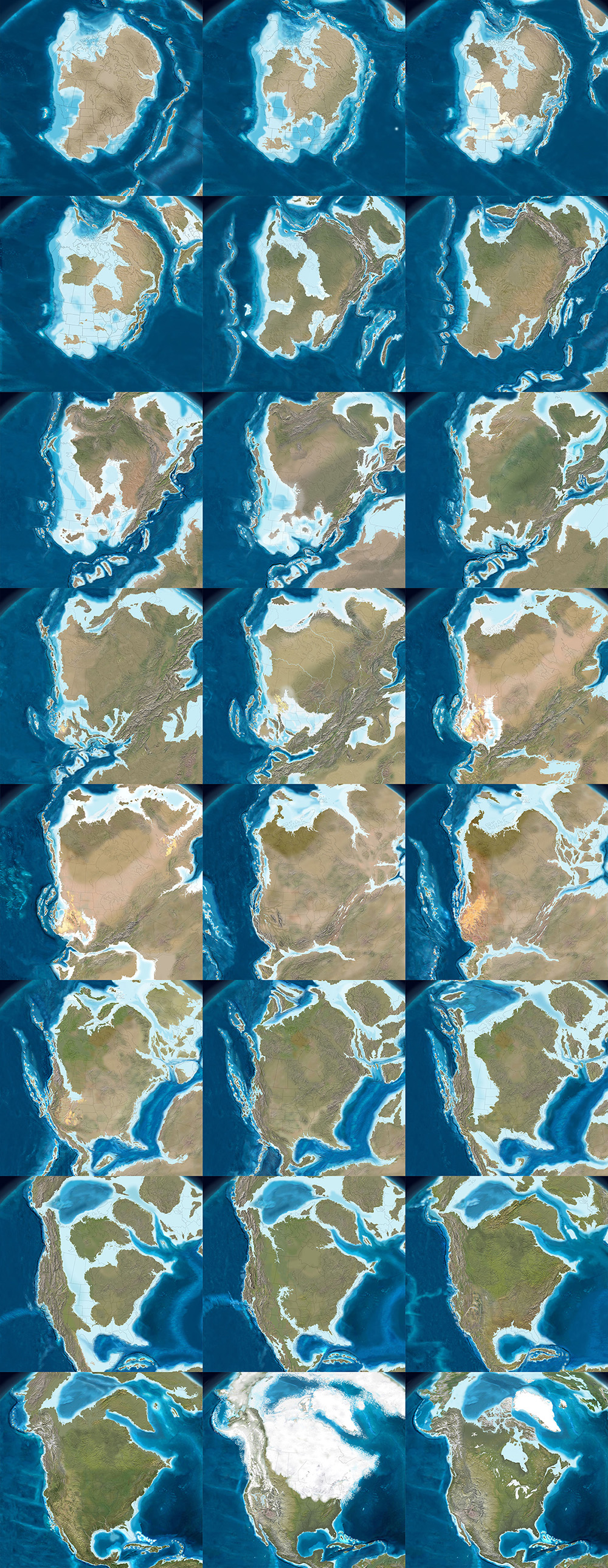
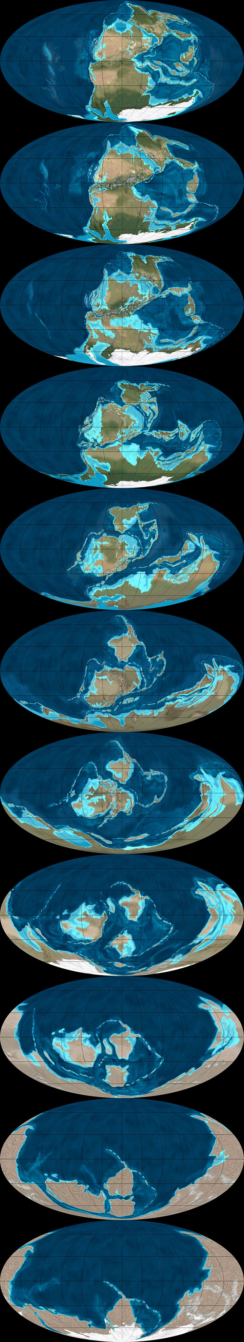
 [Image: The west coast of North America as it appeared roughly 215 million years ago; map by Ron Blakey]. [Image: The west coast of North America as it appeared roughly 215 million years ago; map by Ron Blakey].
The paleo-tectonic maps of retired geologist Ronald Blakey are mesmerizing and impossible to forget once you've seen them. Catalogued on his website Colorado Plateau Geosystems, these maps show the world adrift, its landscapes breaking apart and reconnecting again in entirely new forms, where continents are as temporary as the island chains that regularly smash together to create them, on a timescale where even oceans that exist for tens of millions of years can disappear leaving only the subtlest of geological traces.
With a particular emphasis on North America and the U.S. Southwest—where Blakey still lives, in Flagstaff, Arizona—these visually engaging reconstructions of the Earth's distant past show how dynamic a planet we live on, and imply yet more, unrecognizable changes ahead.
The following images come from Ron Blakey's maps of the paleotectonic evolution of North America. The first map shows the land 510 million years ago, progressing from there—reading left to right, top to bottom—through the accretion and dissolution of Pangaea into the most recent Ice Age and, in the final image, North America in its present-day configuration.
As part of BLDGBLOG's collaborative side-project, Venue, Nicola Twilley and I met with Blakey in his Flagstaff home to talk about the tectonic processes that make and remake the surface of the Earth, the difficulty in representing these changes with both scientific accuracy and visual panache, and the specific satellite images and software tools he uses to create his unique brand of deep-time cartography.
Like film stills from a 600-million year-old blockbuster, Blakey's maps take us back to the Precambrian—but there are much older eras still, stretching unmapped into far earlier continents and seas, and there are many more billions of years of continental evolution to come. Blakey talked us through some of the most complex changes in recent geological history, including the opening of the North Atlantic Ocean, and he allowed himself to speculate, albeit briefly, about where Earth's continental crust might yet be headed (including a possible supercontinent in the Antarctic).
Many of Blakey's maps are collected in the book Ancient Landscapes of the Colorado Plateau, written with Wayne Ranney, where Blakey also describes some of the research and methods that went into producing them. Blakey also contributed to the recent, new edition of a textbook by Wolfgang Frisch and Martin Meschede, Plate Tectonics: Continental Drift and Mountain Building, a thorough exploration of landscapes disassembling and colliding over vast spans of time.
• • •
 [Image: The west coast of North America, depicted as it would have been 130 million years ago; the coast is a labyrinth of islands, lagoons, and peninsulas slowly colliding with the mainland to form the mountains and valleys we know today. Map by Ron Blakey].
Geoff Manaugh [Image: The west coast of North America, depicted as it would have been 130 million years ago; the coast is a labyrinth of islands, lagoons, and peninsulas slowly colliding with the mainland to form the mountains and valleys we know today. Map by Ron Blakey].
Geoff Manaugh: When I first discovered your maps showing the gradual tectonic re-location of the continents over hundreds of millions of years, I thought this was exactly what geologists should be doing: offering clear, step-by-step visual narratives of the evolution of the earth’s surface so that people can better understand the planet we live on. What inspired you to make the maps, and how did you first got started with them?
Ronald Blakey: Well, the very first maps I made were in conjunction with my doctoral thesis, back in the early 1970s. Those were made with pen and ink. I made sketches to show what the paleogeography would have looked like for the specific formation I was studying with my doctorate. Three or four of those maps went into the thesis, which was then published by the Utah Geologic Survey. I’ve also done a number of papers over the years where I’ve made sketches.
But I was late getting into the computer. Basically, during my graduate work I never used a computer for anything. I kind of resisted it, because, for the kind of work I was doing, I just didn’t see a need for it—I didn’t do quantifiable kinds of things. Then, of course, along comes email and the Internet. I actually forget when I first started with Photoshop—probably in the mid-1990s. When I found that, I just thought, wow: the power of this is incredible. I quickly learned how to use the cloning tool, so that I could clone modern topography onto ancient maps, and that made things even simpler yet.
Another thing I started doing was putting these maps into presentations. There were something like five different programs back there, in the late 90s, but the only one that survived was PowerPoint—which is too bad, because it was far from the best of the programs. I was using a program called Astound, which was far superior, particularly in the transitions between screens. I could do simple animations. I could make the tectonic plates move, create mountain belts, and so forth.
I retired in May of 2009, but all of my early maps are now online. With each generation of maps that I’ve done, there has been a noted improvement over earlier maps. I find new techniques and, when you work with Photoshop as much as I do, you learn new ideas and you find ways to make things that were a little clumsy look more smooth.
Manaugh: Where does the data come from?
Blakey: It comes from various publications. You can get a publication and have that PDF open, showing what something looked like in the past, and work from that. Usually, what I’m working from are fairly simple sketches published in the literature. They’ll show a subduction zone and a series of violent arcs, or a collision zone. What I do is take this information and make it more pictorial.
If you create a series of maps in sequence, you can create them in such a way that certain geologic events, from one time slice to the next, to the next, to the next, will blend. It depends a lot on the scale of what you’re trying to show—the whole world versus just four or five states in the West.
Now, throughout the years from, let’s say, 2004 until I retired in 2009, I kept improving the website. I envisioned most of this as educational material, and I didn’t pay much attention to who used it, how they used it, and so forth. But, then, shortly before I retired, various book companies and museums—and, most recently, oil companies—have approached me. So I started selling these and I tried very diligently not to allow this to overlap with what I was doing for my teaching and my research at the University.
In the following long sequence of images, we see the evolution of the west coast of North America, its state boundaries ghosted in for reference. Sea levels rise and fall; island chains emerge and collide; mountains form; inland seas proliferate and drain; and, eventually, modern day California, Vancouver Island, and the Baja peninsula take shape, among other recognizable features. The time frame represented by these images is approximately 500 million years. All maps by Ron Blakey.
 Nicola Twilley
: What do the oil companies want them for?
Blakey: They’re my biggest customers now. Usually, the geologists at oil companies are working with people who know either much less geology than they do or, in some cases, almost no geology at all, yet they’re trying to convince these people that this is where they need to explore, or this is what they need to do next.
They find these maps very useful to show what the Devonian of North Dakota looked like, for example, which is a hot spot right now with all the shales that they’re developing in the Williston Basin. What they like is that I show what the area might have really looked like. This helps, particularly with people who have only a modest understanding of geology, particularly the geologic past.
Manaugh: What have been some of the most difficult regions or geological eras to map?
Blakey: The most difficult thing to depict is back in the Paleozoic and the Mesozoic. Large areas of the continent were flooded, deep into the interior.
During certain periods, like the Ordovician, the Devonian, and parts of the Jurassic—especially the Cretaceous—as much as two-thirds of the continents were underwater. But they’re still continents; they’re still continental crusts. They’re not oceans. The sea level was just high enough, with respect to where the landscape was at the time, that the area was flooded. Of course, this is a concept that non-geologists really have problems with, because they don’t understand the processes of how continents get uplifted and subside and erode and so forth, but this is one of the concepts that my maps show quite nicely: the seas coming in and retreating.
But it’s very difficult—I mean, there is no modern analog for a seaway that stretched from the Mackenzie River Delta in Canada to the Gulf of Mexico and that was 400 miles wide. There’s nothing like that on Earth today. But the styles of mountains have not dramatically changed over the last probably two billion years—maybe even longer than that. I don’t go back that far—I tend to stick with the last 600 million years or so—but the styles of mountains haven’t changed. The nature of island arcs hasn’t changed, as far as we know.
What has changed is the amount of vegetation on the landscape. My maps that are in the early part of the Paleozoic—the Cambrian and the Ordovician early part of the Silurian—tend to be drab-colored. Then, in the late Silurian and in the Devonian, when the land plants developed, I start bringing vegetation colors in. I try to show the broad patterns of climate. Not in detail, of course—there’s a lot of controversy about certain paleoclimates. But, basically, paleoclimates follow the same kinds of regimens that the modern climates are following: where the oceans are, where the equator is, where the mountain ranges are, and so forth.
That means you can make broad predictions about what a paleoclimate would have been based on its relationship to the equator or based on the presence or absence of nearby mountains. I use these kinds of principles to show more arid areas versus more humid areas.
The next three sequences show the evolution of the Earth's surface in reverse, from the present day to, at the very bottom, 600 million years ago, when nearly all of the planet's landmasses were joined together in the Antarctic. The first sequence shows roughly 90 million years of backward evolution, the continents pulling apart from one another and beginning a slow drift south. They were mapped using the Mollweide projection, and, in all cases, are by Ron Blakey.
 Twilley
: And you paint the arid area based on a contemporary analog?
Blakey: Right. I know the modern world reasonably well and I’ll choose something today that might have matched the texture and aridity of that older landscape.
I use a program called GeoMapApp that gives me digital elevation maps for anywhere in the world. Most recently, they have coupled it with what they call the “Blue Marble.” NASA has stitched together a bunch of satellite photos of the world in such a way that you can’t tell where one series of photos come in or another. It’s a fairly true-color representation of what Earth would look like from space. So this Blue Marble is coupled with the GeoMapApp’s digital elevation topography; you put the Blue Marble over it, and you use a little slider to let the topography show through, and it gives you a fairly realistic looking picture of what you’re looking for.
For example, if I’m working with a mountain range in the southern Appalachians for a Devonian map—well, the southern Appalachians, during the Devonian, were probably far enough away from the equator that it was in the arid belt. There are some indications of that, as well—salt deposits in the Michigan Basin and in parts of New York and so forth. Plus, there are red-colored sediments, which don’t prove but tend to indicate arid environments. This combination tells me that this part of the world was fairly arid. So I’m going to places like modern Afghanistan, extreme western China, northern Turkey, or other places where there are somewhat arid climates with mountain belts today. Then I clone the mountains from there and put them in the map.
But you have to know the geologic background. You have to know how the mountains were formed, what the grain of the mountains was. That’s not always easy, although there are ways of doing it. To know the grain of the mountains, you need to know where the hinterland and the center of the mountains were. You need to know where the foreland area is, so that you can show the different styles of mountains. You have to move from foreland areas—which tends to be a series of parallel ridges, usually much lower than the hinterlands—to the center and beyond.
I use this kind of information to pick the right kind of modern mountain to put back in the Devonian, based on what that Devonian landscape probably had a good chance of looking like. Do we know for certain? Of course not. We weren’t around in the Devonian. But we have a good rock record and we have a lot of information; so we use that information and, then, voilà.
To give another example, let’s look at the Devonian period of the east coast. The big European continent that we call Baltica collided with Greenland and a series of micro-continents collided further south, all the way down at least as far as New Jersey, if not down as far the Carolinas. We know that there are places on Earth today where these same kinds of collisions are taking place—in the Alps and Mediterranean region, and the Caucasus region, and so forth.
We can use the concept that, if two plates are colliding today to produce the Caucasus mountains, and if we look at the style of mountains that the Caucasus are, then it’s reasonable to think that, where Greenland and Baltica collided in the Silurian and the Devonian, the mountains would have had a similar style. So we can map that.
This second sequence shows the continents drifting apart, in reverse, from 105 million years ago to 240 million years ago. They were mapped using the Mollweide projection, and, in all cases, are by Ron Blakey.
 Manaugh
: That collision alone—Baltica and Greenland—sounds like something that would be extremely difficult to map.
Blakey: Absolutely. And it’s not a one-to-one relationship. You have to look at the whole pattern of how the plates collided, how big the plates were, and so forth.
Then there’s the question of the different histories of particular plates. So, for example, most of Scotland started out as North America. Then, when all the continents collided to form Pangaea, the first collisions took place in the Silurian-Devonian and the final collisions took place in the Pennsylvanian-Permian. By, say, 250 million years ago, most of the continents were together. Then, when they started to split apart in the Triassic and Jurassic—especially in the Triassic and Cretaceous—the split occurred in such a way that what had been part of North America was actually captured, if you will, by Europe and taken over to become the British Isles.
Scotland and at least the northern half of Ireland were captured and began to drift with Europe. On the other hand, North America picked up Florida—which used to be part of Gondwana—and so forth.
One of the things that is interesting is the way that, when mountains come together and then finally break up, they usually don’t break up the same way that they came together. Sometimes they do, but it has to do with weaknesses, stress patterns, and things like this. Obviously, all time is extremely relative, but mountains don’t last that long. A given mountain range that’s been formed by a simple collision—not that there’s any such thing as a simple collision—once that collision is over with, 40 or 50 million years after that event, there is only low-lying landscape. It may have even have split apart already into a new ocean basin.
But here’s the important part: the structure that was created by that collision is still there, even though the mountains have been worn down. It’s like when you cut a piece of wood: the grain is still inherited from when that tree grew. The pattern of the grain still shows where the branches were, and the direction of the tree’s growth in response to wind and sun and its neighbors. You can’t reconstruct the tree exactly from its grain, but, if you’re an expert with wood, you should be able to look and say: here are the tree rings, and here’s a year where the tree grew fast, here’s a year where the tree grew slow, here’s where the tree grew branches, etc.
In a sense, as geologists, we’re doing the same things with rock structure. We can tell by the pattern of how the rocks are deformed which direction the forces came from. With mountains, you can tell the angle at which the plates collided. It’s usually very oblique. What that tends to do is complicate the geologic structure, because you not only get things moving one way, but you get things dragging the other way, as well. But we can usually tell the angle at which the plates hit.
Then, in many cases, based upon the nature of how the crust has been deformed and stacked up, we can tell the severity of the mountain range. It doesn’t necessarily mean that we can say: oh, this structure would have been a twenty-thousand-foot high mountain range. It’s not that simple at all, not least of which because rocks can deform pretty severely without making towering mountains.
This final of the three global sequences shows the continents drifting apart, in reverse, from 260 million years ago to 600 million years ago. There was still nearly 4 billion years of tectonic evolution prior to where these maps begin. They were mapped using the Mollweide projection, and, in all cases, are by Ron Blakey.
 Manaugh
: Are you able to project these same tectonic movements and geological processes into the future and show what the earth might look like in, say, 250 million years?
Blakey: I’ve had a number of people ask me about that, so I did make some global maps. I think I made six of them at about 50-million-year intervals. For the fifteen to 100-million-year range, I think you can say they are fairly realistic. But, once you get much past 75 to 100 million years, it starts to get really, really speculative. The plates do strange things. I’ll give you just a couple of quick examples.
The Atlantic Ocean opened in the beginning of the Jurassic. The actual opening probably started off the coasts of roughly what is now Connecticut down to the Carolinas. That’s where the first opening started. So the central part of the Atlantic was the first part to open up. It opened up reasonably simply—but, again, I’m using the word simple with caution here.
The north Atlantic, meanwhile, didn’t open up until about 60 to 50 million years ago. When it opened up, it did a bunch of strange things. The first opening took place between Britain and an offshore bank that’s mostly submerged, called Rockall. Rockall is out in the Atlantic Ocean, northwest of Ireland—near Iceland—but it’s continental crust. That splitting process went on for, let’s say, ten million years or so—I’m just going to talk in broad terms—as the ocean started opening up.
Then the whole thing jumped. A second opening began over between Greenland and North America, as Greenland and North America began to separate off. That lasted for a good 40 or 50 million years. That’s where you now get the Labrador Sea; that is actual ocean crust. So that was the Atlantic Ocean for thirty or forty million years—but then it jumped again, this time over between Greenland and what is now the west coast of Europe. It started opening up over there, before it jumped yet again. There’s an island in the middle of the North Atlantic, way the heck up there, called Jan Mayen. At one time, it was actually part of Greenland. The Atlantic opened between it and Greenland and then shifted to the other side and made its final opening.
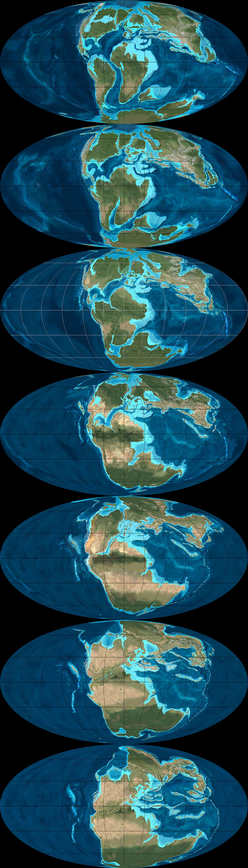
The following two sequences show the evolution of Europe from an Antarctic archipelago to a tropical island chain to the present day Europe we know and recognize. The first sequence starts roughly 450 million years ago and continues to the Jurassic, 200 million years ago. All maps by Ron Blakey.

So it’s very complicated. And that’s just the Atlantic Ocean.
The Northern Atlantic took at least five different paths before the final path was established, and it’s all still changing. In fact, the south Atlantic is actually even worse; it’s an even bigger mess. You’ve got multiple openings between southwest Africa and Argentina, plus Antarctica was up in there before it pulled away to the south.
These complications are what makes this stuff so interesting. If we look at events that we can understand pretty well over the last, let’s say, 150 or 200 million years of time—where we have a good indication of where the oceans were because we still have ocean crusts of that age—then we can extrapolate from that back to past times when oceans were created and destroyed. We can follow the rules that are going on today to see all of the oddities and the exceptions and so forth.
These are the kinds of things I try to keep track of when I’m making these maps. I’m always asking: what do we know? Was it a simple pull-apart process? There are examples where continents started to split across from one another, then came back together, then re-split in a different spot later on. That’s not just speculation—there is geologic evidence for this in the rock record.
So, when it comes to extrapolating future geologies, things become very complicated very quickly. If you start thinking about the behavior of the north Atlantic, creating a projection based on what’s going on today seems, at first, like a fairly simple chore. North America is going on a northwesterly path at only one or two centimeters a year. Europe is moving away, at almost a right angle, at about another centimeter a year. So the Atlantic is only opening at three centimeters a year; it’s one of the slowest-opening oceans right now.
OK, fine—but what else is happening? The Caribbean is pushing up into the Atlantic and, off South America, there is the Scotia Arc. Both of those are growing. They’ve also identified what looks like a new island arc off the western Mediterranean region; that eventually would start to close the Atlantic in that area. Now you start to speculate: well, these arcs will start to grow, and they’ll start to eat into the oceans, and subduct the crusts, and so forth.
Again, for the first 50, 75, or even 100 million years, you can say that these particular movements are fairly likely. But, once you get past that, you can still use geologic principles, but you’re just speculating as to which way the continents are going to go.
For instance, the one continent that does not seem to be moving at all right now, relative to anything else, is Antarctica. It seems to be really fixed on the South Pole. That’s why some people think that everything will actually coagulate back towards the South Pole. However, there are also a bunch of subduction zones today along southern Asia, and those are pretty strong subduction zones. Those are the ones that created the big tsunami, and all the earthquakes off of Indonesia and so forth. Eventually, those could pull either parts of Antarctica or all of Antarctica up toward them.
But I’m more interested in reconstructing the past than I am the future, so I’ve only played around with those five or six maps.
This second sequence, showing the next phase in the evolution of Europe, begins approximately 150 million years ago and extends to the present day. All maps by Ron Blakey.
 Manaugh
: To ground things a bit, we’re having this conversation in Flagstaff, on the Colorado Plateau, which seems like a great place to teach geology. I wonder whether there might be another Colorado Plateau, so to speak, elsewhere in the world—something geologically similar to the extraordinary landscapes we see here that just hasn’t had the chance to emerge. Maybe the tectonics aren’t right, and it’s still just a crack, rather than a canyon, or maybe it’s covered in vegetation or ice so we can’t see it yet. Conversely, I’m curious if you might have found evidence of other great geological districts in the earth’s past—lost Grand Canyons, other Arches National Parks—that have been lost to time. How could we detect those, and where are they?
Blakey: This is indeed a great place to teach geology. It’s a great place to live.
As for Colorado Plateau analogs—it’s an interesting question. There’s an area in South America that I’d say is fairly similar. It’s got a couple of famous national parks that I can't remember the name of. It’s a smaller version, but it’s very similar to the Colorado Plateau. It’s between the Andes and the Amazon basin, part of the general pampas region there of South America. It even has similarly aged rocks. Parts of northern Africa would also be similar.
But you have to look at all the characteristics of the Plateau. Number one: the rocks are flat. Number two: the rocks have been uplifted. Number three: the rocks are dissected by a major river system. Number four: it’s a semi-arid climate. There are probably five or six defining characteristics in total, and I’ve heard many people say that there is no other place else on Earth that has all those characteristics in exactly the same way. But I went to an area in eastern Mauritania many years ago, where, for all the world, it looked like the Grand Canyon. It wasn’t as colorful, but it was a big, deep canyon.
In fact, the Appalachian Plateau would be somewhat similar, except it’s in a humid climate, which means the land has been shaped and formed differently. But the Appalachian plateau has flat-lying rocks; it’s dissected by some major rivers; it’s experienced uplift; and so forth.
The next two sequences of images, followed from left to right, top to bottom, illustrate the gradual evolution of the Colorado Plateau, where, in its modern day incarnation, this interview with Ron Blakey took place (specifically, in Flagstaff, Arizona. The earliest map included here depicts the Proterozoic; the first sequence ends in the Triassic. All maps by Ron Blakey.
 Twilley
: I’m interested in the representational challenges you face when you decide to make a map, and, specifically, when you’re in Photoshop, what your most-used tools might be. I thought it was fascinating when you said that the cloning tool really changed how you make geological maps. What other techniques are important to you, in order to represent geological histories?
Blakey: Oh, the cloning tool is the most important, by far—at least when I’m actually painting. Of course, I use the outline tool to select areas, but, when I’m actually painting, it would be impossible to paint these different maps pixel by pixel. I couldn’t do it. Occasionally, I will actually hand-draw some things in the flatlands, where I want to put a river system, for example, but, at least for mountains and rugged terrain, I clone everything.
Some times, I’ll cut and paste. I’ll select an area in the GeoMapApp, I save it as a JPEG, and then I can select it and copy it and paste it in, and I can rotate and deform it a little bit. Are you familiar with the warp tool in Photoshop? I use that a lot, because you can change the shape of mountains a little. If you do it too dramatically, it really looks flaky. But, if you do it right, it still looks pretty realistic.
This second sequence, also showing the evolution of the Colorado Plateau, begins with the Triassic and ends roughly 5 million years ago—basically the present day, in geological terms. All maps by Ron Blakey.
 Twilley
: And do you have certain filters you rely on for particular geological effects?
Blakey: A little bit. I like to use the craquelure filter. It actually gives you little bumps and valleys and so forth. I use that especially for continental margins. Continental margins are anything but regular slopes, going down to the abyssal depths. They’re very irregular. There are landslides and all kinds of things going on there at the margins, so I add a little texture with craquelure.
It can be difficult to use, though, and it doesn’t work at really high resolutions—so, what I actually have to do some times, is that I will actually copy a part of my map, take it out, make it smaller, do the craquelure on it, and then blow it back up and paste it in again.
 [Image: A painting by Ron Blakey depicts a geological landscape near Sedona, Arizona].
Dee Blakey, Ron's Wife [Image: A painting by Ron Blakey depicts a geological landscape near Sedona, Arizona].
Dee Blakey, Ron's Wife: I think the other reason that he can do what he does is that he paints. That’s one of his paintings over there. [ gestures above fireplace]
Blakey: Well, I guess I should have said that right away, when you asked me why I got interested in this, because I am interested in the artistic aspect of geology. The artistic aspect of science, in general, but especially geology. Astronomy, for example, would be another field where artistic visualizations are useful—any time you’re trying to show things that can’t easily be visualized with something comparable here on present-day planet Earth, you have to use an artistic interpretation.
Anyway, I can’t explain it, but I understand color pretty well. I use the hue saturation tool a lot. I’ll select an area and then I’ll feather it, let’s say, because you don’t want the edges to be sharp. I’ll feather it by thirty, forty, fifty pixels. Then I'll take the slider for hue saturation, where, if you go to the left, you make things redder and, if you go to the right, you make things greener. If I’ve got a landscape that looks a little too humid, I’ll just slide it slightly to the left to make it a bit redder. You can also change the lightness and darkness when you do that. There’s also regular saturation. By killing the saturation, you can really kill the nature of a landscape quite a bit.
And I use hue saturation a lot. That took me a long time to master, because it’s really easy to screw things up with that tool. You start sliding things a little too far and, whoa—wait a minute! All of a sudden, you’ve got purple mountains.
• • •
For more Venue interviews, be sure to stop by the Venue website.
 [Image: The official poster for Sukkah City by Jason Hutt]. [Image: The official poster for Sukkah City by Jason Hutt].
A documentary film about the Sukkah City design competition from 2010 is finally on its way into the public eye, with a free outdoor premiere this weekend in New York City's Union Square.
The filmmaker, Jason Hutt, will be on hand for the 7pm screening, and two further showings are planned for Monday and Tuesday of next week at Manhattan's Jewish Community Center.
A short trailer for the film appears below:
I had the pleasure of serving on the design jury for the competition, which I still think back to fondly, as it was a brilliant premise for an architectural competition.
The sukkah itself is, in the words of competition organizer Joshua Foer, "an ephemeral, elemental shelter, erected for one week each fall, in which it is customary to share meals, entertain, sleep, and rejoice. Ostensibly the sukkah's religious function is to commemorate the temporary structures that the Israelites dwelled in during their exodus from Egypt, but it is also about universal ideas of transience and permanence as expressed in architecture."
For an architect, the constraints are both inspiring and extraordinary: the structure must be temporary, have at least two and a half walls, be big enough to contain a table, and have a roof made of shade-providing organic materials through which one can see the stars. Yet a deep dialogue of historical texts intricately refines and interprets these constraints—arguing, for example, for a 27 x 27 x 38-inch minimum volume; for a maximum height of 30 feet; for walls that cannot sway more than one handbreadth; for a mineral and botanical menagerie of construction materials; and even, in one famous instance, whether it is kosher to adaptively reuse a recently deceased elephant as a wall. (It is.) The paradoxical effect of these constraints is to produce a building that is at once new and old, timely and timeless, mobile and stable, open and enclosed, homey and uncanny, comfortable and critical. You can see the final, realized constructions in Union Square here:
The free screening is at 7pm on Sunday, September 22, on the north end of Union Square. Hope to see some of you there.
 [Image: From "Almost Nature" by Gerco de Ruijter]. [Image: From "Almost Nature" by Gerco de Ruijter].
The previous post reminded me of the work of Dutch photographer Gerco de Ruijter, whose fantastic images of gridded, altered, and semi-artificial landscapes have been featured here on the blog before, first with a stunning series of low-altitude aerial shots of tree farms, taken with cameras mounted on kites and fishing rods, then with a video of circular crop-irrigation landscapes in the western U.S., and, last but not least, with a disorienting urban video shot by a flying pigeon.

 [Images: From "Almost Nature" by Gerco de Ruijter].
For the current project seen here, called " Almost Nature," de Ruijter took aerial photos of a tree nursery in Boskoop, "the nursery center of Holland," where nearly 2,200 acres' worth of controlled tree growth is underway at any given time.
 [Image: From "Almost Nature" by Gerco de Ruijter]. [Image: From "Almost Nature" by Gerco de Ruijter].
Fascinatingly—although unrelated to de Ruijter's work—we read that " construction in Boskoop is very expensive, because Boskoop sits on an ancient bog."
Construction must either be anchored into the ancient sea bed, which is about 60 feet deep in this area, or "float" in place on the bog on a special kind of raft. Until fairly recently, heavy structures were built on the top of alternating layers of logs (which float) and cow hides (which seal out the water). Even some old cathedrals were built in this manner. Gouda Cathedral is an example.
The Gouda cathedral is thus a kind of earth-ship, a vessel floating unanchored on a "special kind of raft" easy to mistake for architectural foundations.

 [Images: From "Almost Nature" by Gerco de Ruijter]. [Images: From "Almost Nature" by Gerco de Ruijter].
In any case, the short text de Ruijter wrote for the series points out, in fact, that "all these little plants are clones" and that "each color descends from the same source. Standing in a square tray they resemble the photographic pixel."
With this in mind, you could presumably undertake a project to plant these trees in a way that would produce an eventual, albeit very low-resolution, JPG—or, given the lifetime growth and seasonal changes of the trees, an animated GIF, combining digital representation with forestry and turning the aerial view into a new kind of living cinema.

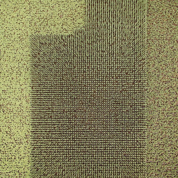 [Images: From "Almost Nature" by Gerco de Ruijter]. [Images: From "Almost Nature" by Gerco de Ruijter].
You can see Boskoop on Google Maps, where the pixellation de Ruijter describes is obvious—if not as immediately captivating as it appears in his own photos—in the carefully managed greenhouses, nurseries, and local agriculture of the area.
The landscape from above is almost more like a series of polychromatic test-swatches, like something you might use to check the sensors of satellites with.
 [Image: From "Almost Nature" by Gerco de Ruijter].
Meanwhile, de Ruijter's CROPS video is currently on display at the Hirschhorn Museum in Washington D.C., where he will also be speaking about his work on Tuesday, October 8th, at 8pm, at an event that is free and open to the public, and there will also be a short presentation in the gallery space itself on Friday, October 11th, at 12:30pm.
 [Image: From "Almost Nature" by Gerco de Ruijter].
Michel Banabila [Image: From "Almost Nature" by Gerco de Ruijter].
Michel Banabila, the composer for CROPS, will be performing a live ambient music set on Friday, September 20th, at 12:30pm, as well.
If you're in D.C., stop by.
 [Image: Photo by Gerco de Ruijter, via but does it float]. [Image: Photo by Gerco de Ruijter, via but does it float].
A short article by Sam Kean for the Chemical Heritage Foundation in Philadelphia explores the world of " bizarro ice—ice that burns, ice that sinks instead of floating, ice literally out of this world." For the most part, these are ices that have formed under extraordinary pressure, whether naturally or artificially applied, which "forc[es] H2O molecules into rhombuses, tetragons, and other alternative geometries."
In some cases, the pressure is so great that the resulting ice "can stay solid at temperatures of thousands of degrees—a true freezer burn. If you could somehow plop chunks of these ices into a glass of liquid water, they’d vaporize it." Incredibly, we read that, "at super-high pressures, some chemists predict that ice transforms into a metal."
There is an ice "that’s structurally similar to diamonds," Kean explains, that "probably exists in the upper atmosphere." And there are exotic ices on other planets: "The dense, hot interiors of Neptune and Uranus probably contain chunks of nonhexagonal ices, as do exoplanets around distant stars, a potentially important consideration as we search for life beyond our solar system."
 [Image: The Sea of Ice by Caspar David Friedrich]. [Image: The Sea of Ice by Caspar David Friedrich].
This latter remark brings to mind a book I downloaded in my recent PDF binge called The Science of Solar System Ices, edited by Murthy S. Gudipati and Julie Castillo-Rogez. It's a mammoth book—more than 650 pages—that explores exotic ices found in comets, on exoplanets, on moons, and elsewhere in our solar system.
"The largest deposits of carbon dioxide ice," we learn, "is on Mars. Sulfur dioxide ice is found in the Jupiter system. Nitrogen and methane ices are common beyond the Uranian system. Saturn’s moon Titan probably has the most complex active chemistry involving ices, with benzene and many tentative or inferred compounds," including a long list of chemicals I can't even pronounce let alone recognize or describe, forming ices with "unusual colors and spectral shapes." There are even "organic" ices made of hydrocarbons.
 [Image: The Monk by the Sea by Caspar David Friedrich]. [Image: The Monk by the Sea by Caspar David Friedrich].
How these ices produce landscapes is by far the most interesting aspect here, at least from the point of view of BLDGBLOG: how they glaciate, experience gravitational tides and weathering, melt from below due to volcanoes, reflect the alien skies shining down on them in distorted shapes and angled echoes, and even how they tectonically fracture into karst-like networks of sinkholes and caves.
Imagining snow storms of frozen methane on other planets while thinking about, for example, human artistic traditions of landscape representation, from the Hudson Valley School to Caspar David Friedrich—picturing massive and extraordinary widescreen scenes of glacial hills and valleys steaming in the outer darkness of the solar system and the paintings or photographs or even animated GIFs that might result—would extend the idea of the sublime to non-terrestrial landscapes and the sights they might someday reveal to human explorers.
 [Image: Walking into a glacier: "Grindelwald Grotto, Bernese Oberland, Switzerland," courtesy of the Library of Congress Prints & Photographs Division].
Art historians would gaze in awe at offworld glaciers of carbon dioxide ice and howling massifs of frozen nitrogen, where volcanoes erupt not with liquid rock but with "ice slurries" and groundwater exploding onto the landscape with the force of a Kilauea.
Perhaps someday you'll be able to get a degree in the field of exploratory xenoglaciology, the study of rare and incredible landforms made of frozen chemicals in space.
("Wild Ice" story spotted via @nicolatwilley).
|
|


