[Image: New York's Cathedral of St. John the Divine under construction, a Piranesian gyroscope of arched masonry and brick; courtesy Museum of the City of New York].
By sheer coincidence, I was looking back through the archives of a blog called Unurthed the other day—a great, although seemingly now-defunct site written by Greg Pass—where I read about the so-called "Lüscher color test."
The test, according to that font of accurate historical insight, Wikipedia, was "a psychological test invented by Dr. Max Lüscher in Basel, Switzerland... Lüscher believed that because the color selections are guided in an unconscious manner, they reveal the person as they really are, not as they perceive themselves or would like to be perceived. He believed that personality traits could be identified based on one’s choice of color. Therefore, subjects who select identical color combinations have similar personalities."
[Image: Lüscher red].
Think of it as a more interesting, albeit still pseudoscientific version of the asinine Myers-Briggs Test, the latter of which is a scientifically useless form of personality evaluation that, in this age of anti-vaxxers, chemtrail conspiracists, and the politically motivated rejection of climate change science, has undergone a disquieting resurgence.
[Image: Lüscher green].
Lüscher's test was altogether more colorful, leading to a peacock's tail of brilliantly printed playing cards from which a person would choose their preferred hues.
I say I was reading that post on Unurthed "by sheer coincidence," because I was interested to see that Core77—which underwent a substantial redesign earlier this year and is worth checking out, if you haven't do so already—just posted about federal color regulations in the United States, inspired by a short article in the Washington Post.
U.S. color regulations, we read, give specific instructions for everything from how to paint U.S.P.S. post boxes and what Forest Service signs are meant to look like, to the specific color of Navy torpedoes and even a hue known as "Radome tan."
[Image: Federal Color #13415, School Bus Yellow].
Seeing those two posts one right after the other, however, despite their separation by years online, was almost jarring, like something straight out of a Thomas Pynchon novel: the U.S. federal color standards seen as a sort of unacknowledged color-personality evaluation involuntarily imposed on the populace, a Lüscher test for the entire nation.
[Image: Federal Color #15095, Post Office Light Blue].
Think of the central spatial premise of Rupert Thomson's under-rated 2005 novel Divided Kingdom, previously discussed on BLDGBLOG a long while back.
Thomson describes a UK split up into four sub-nations based on personality, where each personality type has been given a color—Yellow, Green, Blue, or Red—that reflects their emotional disposition.
I mention this here not to argue about the political viability of such a scenario, but to point out that the inadvertent juxtaposition of the Lüscher color test with the closely regulated system of colors "used in government procurement" suggests a peculiar variation on that novel's core idea, as if the infrastructure around us is really a homeopathic, color-based personality test in disguise.
Where you like to drive, and the kinds of spaces and institutions you're attracted to or repelled by, would all be part of an undeclared, immersive evaluation procedure coextensive with the federal landscape.
[Image: Federal Color #14066, DoT Highway Green].
While Thomson's novel—at least as far as I recall—does not propose the actual color-coding of urban infrastructure to reflect inhabitants' emotional state, it is not a huge leap to assume that the application of certain colors on a large enough scale could begin to exert Lüscher-like personality effects.
Surely there's a YA dystopian novel in that somewhere... Which color are you?
If you're in NYC later today, the Center for Genomic Gastronomy and Edible Geography have teamed up to explore the culinary implications of air pollution with a "smog-tasting cart."
According to their press release, the collaborators are "delighted to offer New Yorkers their first opportunity to conduct a side-by-side tasting of air from different cities":
A smog-tasting cart, complete with precursor chemicals, smog chamber, and whisk, will be serving free smog meringues from four different locations, as part of an installation and performance that aims to transform otherwise abstract air quality data and passive inhalation into an aesthetically, emotionally, and politically charged experience.
Being married to Nicola Twilley, the author of Edible Geography, I was able to tag along during part of the research process, including a visit to the world's largest artificial "smog chamber" at the Bourns College of Engineering in Riverside, California.
The place had the feel of a sci-fi air factory, where microcosmic research-atmospheres were being mixed and baked into existence under the heat of countless black lights. It was a kiln for new skies.
[Image: The reflective walls of the smog chamber under endless black light; Instagram by BLDGBLOG].
Our visit was essentially an immersive chemistry lesson, as we stepped into a huge reflective room—the aforementioned smog chamber—used for experimentally recreating specific urban atmospheres, and we learned how different chemicals react at different concentrations to create specific aerial effects such as smog.
Even smog has its own classes and types; there are Atlanta-style smogs, London-style smogs, Los Angeles-style smogs. If I remember correctly, Beijing has London-style smog, whereas Santiago, I believe, has Los Angeles-style smog.
The next and seemingly most obvious question, of course, would be whether or not you could mix and match the atmospheric conditions of different cities to create synthetic, previously impossible smogs—aerial effects that are heavy with everything from automobile exhaust and cooking smoke to pine oils and other plant-based resins—to create speculative smogs for cities or landscapes that don't exist.
Even other planets have their own heavy weather and distinct atmospheres, of course; could there be interplanetary smog research, cooked into meringue form and experienced as a new suite of tastes?
[Image: Smog chamber black lights; photo by BLDGBLOG].
As Nicola Twilley describes it, this all got her thinking "about the concept of 'aeroir,' and the idea that urban atmospheres capture a unique taste of place." This would be a dispersed, atmospheric variation of terroir, from the world of wine:
This smog-tasting cart is intended as the start of a larger collaboration exploring the concept of “aeroir.” After all, air is the site at which we have an intimate, constant interaction with a geographically specific manifestation of urban planning, economic activity, environmental regulation, and meteorological forces. We hope to develop a multi-sensory series of installations, devices, and performances to make that interaction sense-able.
Stop by the smog cart today if you'd like to ask the artists more about their project, or if you simply want a free meringue.
[Image: Barrel vaults beneath Warren Street, Manhattan; Instagram by BLDGBLOG].
I was walking along Warren Street in Manhattan yesterday evening when I saw what appeared to be a series of brick barrel vaults uncovered by roadworks.
There was no one around, so no one to ask whether it was a deliberate historical excavation or just some street repair, but the incision seemed remarkably, even archaeologically, precise, complete with an exposed water pipe left hanging in midair.
[Image: Barrel vaults beneath Warren Street, Manhattan; Instagram by BLDGBLOG].
Discovering brick vaults beneath the streets of Manhattan seems both totally unsurprising—in the sense that seemingly anything can and will be found there, in the otherworldly cosmos that is the island of Manhattan—and a total shock, as if something more appropriate for Rome had installed itself beneath the streets unnoticed.
Perhaps it's someone's cellar roof and it needs new brickwork; perhaps it's some strange old Bazalgettian sewer outflow linking up to the city's older drains; or perhaps there's a vast cobweb of vaults extending everywhere beneath the streets of Lower Manhattan, holding up the streets and buildings like an architectural super-foam, huge caverns of masonry and brick in a labyrinth of basements inside of basements, and this is just the first glimpse of the upper floor.
In the distant summer of 2002, I worked for a few months at Foster + Partners in London, tasked with helping to archive Foster's old sketchbooks, hand-drawings, and miscellaneous other materials documenting dozens of different architectural projects over the past few decades.
On a relatively slow afternoon, I was given the job of sorting through some old cupboards full of videocassettes—VHS tapes hoarded more or less randomly, sometimes even without labels, in a small room on the upper floor of the office.
Amongst taped interviews from Foster's various TV appearances, foreign media documentaries about the office's international work, and other bits of A/V ephemera, there were a handful of tapes that consisted of nothing but surveillance footage shot inside the old Wembley Stadium.
It was impossible to know what the tapes—unlabeled and shoved in the back of the cupboard—actually documented, but the strange visual language of CCTV is such that something always seems about to happen. There is a strange urgency to surveillance footage, despite its slow, almost glacial pace: a feeling of intense, often dreadful anticipation. A crime, an attack, an explosion or fire is, it seems, terrifyingly imminent.
Unsure of what I was actually watching for, it began to feel a bit sinister: had there been an attack or even a murder in the old Wembley Stadium, prior to Foster + Partners' new design at the site, and, for whatever reason, Foster held on to security tapes of the incident? Was I about to see a stabbing or a brawl, a small riot in the corridors?
More abstractly, could an architect somehow develop an attachment, a dark and unhealthy fascination, with crimes that had occurred inside a structure he or she designed—or, in this case, in a building he or she would ultimately demolish and replace?
It felt as if I was watching police evidence, sitting there, alone on a summer afternoon, waiting nervously for the depicted crime to begin.
The relationship not just between architecture and crime, but between architects and crime began to captivate me.
Of course, it didn't take long to realize what was really happening, which was altogether less exciting but nevertheless just as fascinating: these unlabeled security tapes hidden in a cupboard at Foster + Partners hadn't captured a crime, riot, or any other real form of suspicious activity.
Rather, the tapes had been saved in the office archive as an unusual form of architectural research: surveillance footage of people milling about near the bathrooms or walking around in small groups through the cavernous back-spaces of the old Wembley stadium would help to show how the public really used the space.
I was watching video surveillance being put to use as a form of building analysis—security tapes as a form of spatial anthropology.
[Image: Unrelated surveillance footage].
Obsessed by this, and with surveillance in general, I went on to write an entire (unpublished) novel about surveillance in London, as well as to see the security industry—those who watch the city—as always inadvertently performing a second function.
Could security teams and surveillance cameras in fact be a privileged site for viewing, studying, and interpreting urban activity? Is architecture somehow more interesting when viewed through CCTV?
To no small extent, that strange summertime task thirteen years ago went on to inform my next book, A Burglar's Guide to the City, which comes out in October.
The book explores how criminals tactically misuse the built environment, with a strong counter-focus on how figures of authority—police helicopter crews, FBI Special Agents, museum security supervisors, and architects—see the city in a very literal sense.
This includes the specialty optical equipment used during night flights over the metropolis, the surveillance gear that is often deployed inside large or complex architectural structures to record "suspicious" activity, and how even the numbering systems used for different neighborhoods can affect the ability of the police to interrupt crimes that might be occurring there.
I'll be talking about all of this stuff (and quite a bit more, including the sociological urban films of William H. Whyte, the disturbing thrill of watching real-life CCTV footage—such as the utterly strange Elisa Lam tape—and what's really happening inside CCTV control rooms) this coming Friday night, May 8, as part of "a series about spectatorship" at UnionDocs in Brooklyn.
The event is ticketed, but stop by, if you get a chance—I believe there is a free cocktail reception afterward—and, either way, watch out for the release of A Burglar's Guide to the City in October 2015.
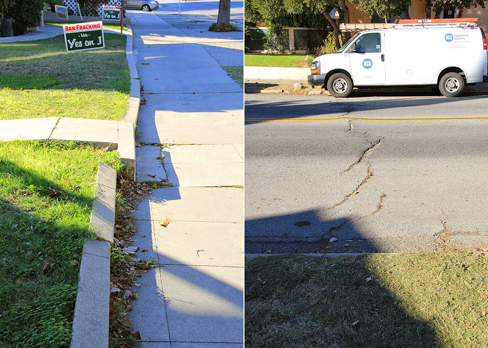
[Image: A curb in Hayward reveals how much the ground is drifting due to “fault creep”: the red-painted part is slowly, but relentlessly, moving north. Photo by Geoff Manaugh].
South of San Francisco, a whole town is being deformed by plate tectonics. These are the slow but relentless landscape effects known as “fault creep.”
An earlier version of this post was first published on The Daily Beast.
The signs that something’s not right aren’t immediately obvious, but, once you see them, they're hard to tune out.
Curbs at nearly the exact same spot on opposite sides of the street are popped out of alignment. Houses too young to show this level of wear stand oddly warped, torqued out of synch with their own foundations, their once strong frames off-kilter. The double yellow lines guiding traffic down a busy street suddenly bulge northward—as if the printing crew came to work drunk that day—before snapping back to their proper place a few feet later.
This is Hollister, California, a town being broken in two slowly, relentlessly, and in real time by an effect known as “fault creep.” A surreal tide of deformation has appeared throughout the city.
[Image: “Fault creep” bends the curbs in Hollister; photo by Geoff Manaugh].
As if its grid of streets and single-family homes was actually built on an ice floe, the entire west half of Hollister is moving north along the Calaveras Fault, leaving its eastern streets behind.
In some cases, doors no longer fully close and many windows now open only at the risk of getting stuck (some no longer really close at all).
Walking through the center of town near Dunne Park offers keen observers a hidden funfair of skewed geometry.
[Image: 359 Locust Avenue, Hollister; photo by Geoff Manaugh].
For example, go to the house at 359 Locust Avenue.
The house itself stands on a different side of the Calaveras Fault than its own front walkway. As if trapped on a slow conveyor built sliding beneath the street, the walk is being pulled inexorably north, with the effect that the path is now nearly two feet off-center from the porch it still (for the time being) leads to.
[Image: The walkway is slowly creeping north, no longer centered with the house it leads to; photo by Geoff Manaugh].
In another generation, if it’s not fixed, this front path will be utterly useless, leading visitors straight into a pillar.
Or walk past the cute Victorian on 5th Street. Strangely askew, it seems frozen at the start of an unexpected metamorphosis.
[Image: Photo by Geoff Manaugh].
Geometrically, it’s a cube being forced to become a rhomboid by the movements of the fault it was unknowingly built upon, an architectural dervish interrupted before it could complete its first whirl.
Now look down at your feet at the ridged crack spreading through the asphalt behind you, perfectly aligned with the broken curbs and twisted homes on either side.
This is the actual Calaveras Fault, a slow shockwave of distortion forcing its way through town, bringing architectural mutation along with it.
[Images: The Calaveras Fault pushes its way through Hollister; photos by Geoff Manaugh].
The ceaseless geometric tumult roiling just beneath the surface of Hollister brings to mind the New Orleans of John McPhee, as described in his legendary piece for The New Yorker, "Atchafalaya."
There, too, the ground is active and constantly shifting—only, in New Orleans, it's not north or south. It's up or down. The ground, McPhee explains, is subsiding.
"Many houses are built on slabs that firmly rest on pilings," he writes. "As the turf around a house gradually subsides, the slab seems to rise." This leads to the surreal appearance of carnivalesque spatial side-effects, with houses entirely detached from their own front porches and stairways now leading to nowhere:
Where the driveway was once flush with the floor of the carport, a bump appears. The front walk sags like a hammock. The sidewalk sags. The bump up to the carport, growing, becomes high enough to knock the front wheels out of alignment. Sakrete appears, like putty beside a windowpane, to ease the bump. The property sinks another foot. The house stays where it is, on its slab and pilings. A ramp is built to get the car into the carport. The ramp rises three feet. But the yard, before long, has subsided four. The carport becomes a porch, with hanging plants and steep wooden steps. A carport that is not firmly anchored may dangle from the side of a house like a third of a drop-leaf table. Under the house, daylight appears. You can see under the slab and out the other side. More landfill or more concrete is packed around the edges to hide the ugly scene.
Like McPhee's New Orleans, Hollister is an inhabitable catalog of misalignment and disorientation, bulging, bending, and blistering as it splits right down the middle.
And there’s more. Stop at the north end of 6th Street, for example, just across from Dunne Park, and look back at the half-collapsed retaining wall hanging on for dear life in front of number 558.
It looks like someone once backed a truck into it—but it’s just evidence of plate tectonics, the ground bulging northward without regard for bricks or concrete.
[Images: A fault-buckled wall and sidewalk bearing traces of planetary forces below; photos by Geoff Manaugh].
In fact, follow this north on Google Maps and you’ll find a clean line connecting this broken wall to the jagged rupture crossing the street in the photographs above, to the paper-thin fault dividing the house from its own front walk on Locust Avenue.
So what’s happening to Hollister?
“Fault creep” is a condition that results when the underlying geology is too soft to get stuck or to accumulate tectonic stress: in other words, the deep rocks beneath Hollister are slippery, more pliable, and behave a bit like talc. Wonderfully but unsurprisingly, the mechanism used to study creep is called a creepmeter.
The ground sort of oozes past itself, in other words, a slow-motion landslide at a pace that would be all but imperceptible if it weren’t for the gridded streets and property lines being bent out of shape above it.
[Image: A curb and street drain popped far out of alignment in Hollister; photo by Geoff Manaugh].
In a sense, Hollister is an urban-scale device for tracking tectonic deformation: attach rulers to its porches and curbs, and you could even take measurements.
The good news is that the large and damaging earthquakes otherwise associated with fault movement—when the ground suddenly breaks free every hundred years or so in a catastrophic surge—are not nearly as common here.
Instead, half a town can move north by more than an inch every five years and all that most residents will ever feel is an occasional flutter.
[Images: Crossing onto the Pacific Plate (heading west) in Parkfield; photo by Geoff Manaugh].
Snyder works on an experiment known as the San Andreas Fault Observatory at Depth, or SAFOD, which has actually drilled down through the San Andreas Fault to monitor what’s really happening down there, studying the landscape from below through sensitive probes installed deep in the active scar tissue between tectonic plates.
On Snyder’s advice, I made my way out to one of the greatest but most thoroughly mundane monuments to fault creep in the state of California. This was in Parkfield, a remote town with a stated population of 18 where Snyder and SAFOD are both based, and where fault creep is particularly active.
In Parkfield there is a remarkable road bridge: a steel structure that has been anchored to either side of the San Andreas Fault like a giant, doomed staple. Anyone who crosses it in either direction is welcomed onto a new tectonic plate by friendly road signs—but the bridge itself is curiously bent, warped like a bow as its western anchorage moves north toward San Francisco.
It distorts more and more every day of the month, every year, due to the slow effects of fault creep. Built straight, it is already becoming a graceful curve.
[Image: Looking east at the North American Plate in Parkfield; photos by Geoff Manaugh].
Parkfield is also approximately where fault creep begins in the state, Snyder explained, marking the southern edge of a zone of tectonic mobility that extends up roughly to Hollister and then begins again on a brief stretch of the Hayward Fault in the East Bay.
Indeed, another suggestion of Snyder’s was that I go up to visit a very specific corner in the city of Hayward, where the curb at the intersection of Rose and Prospect Streets has long since been shifted out of alignment.
Over the past decade—most recently, in 2011—someone has actually been drawing little black arrows on the concrete to help visualize how far the city has drifted in that time.
The result is something like an alternative orientation point for the city, a kind of seismic meridian—or perhaps doomsday clock—by which Hayward’s ceaseless cleaving can be measured.
[Images: A moving curb becomes an inadvertent compass for measuring seismic energy in Hayward; photos by Geoff Manaugh].
Attempting to visualize earthquakes on a thousand-year time span, or to imagine the pure abstraction of seismic energy, can be rather daunting; this makes it all the more surprising to realize that even the tiniest details hidden in plain sight, such as cracks in the sidewalk, black sharpie marks on curbs, or lazily tilting front porches, can actually be real-time evidence that California is on the move.
But it is exactly these types of signs that function as minor landmarks for the seismic tourist—and, for all their near-invisibility, visiting them can still provide a mind-altering experience.
Back in Hollister, Snyder warned, many of these already easily missed signs through which fault creep is made visible are becoming more and more hard to find.
The town is rapidly gentrifying, he pointed out, and Hollister’s population is beginning to grow as its quiet and leafy streets fill up with commuters who can no longer afford to live closer to Silicon Valley or the Bay. This means that the city’s residents are now just a bit faster to repair things, just a bit quicker to tear down structurally unsound houses.
One of the most famous examples of fault creep, for example—a twisted and misshapen home formerly leaning every which way at a bend in Locust Avenue—is gone. But whatever replaces it will face the same fate.
After all, the creep is still there, like a poltergeist disfiguring things from below, a malign spirit struggling to make itself visible.
Beneath the painted eaves and the wheels of new BMWs, the landscape is still on the move; the deformation is just well hidden, a denied monstrosity reappearing millimeter by millimeter despite the quick satisfaction of weekend repair jobs. Tumid and unstoppable, there is little that new wallpaper or re-poured driveways can do to disguise it.
[Image: Haphazard concrete patchwork in a formerly straight sidewalk betrays the slow action of fault creep; photo by Geoff Manaugh].
Snyder remembered one more site in Hollister that he urged me to visit on my way out of town.
In the very center of Hollister’s Dunne Park, a nice and gentle swale “like a chaise longue,” in his words, has been developing.
Expecting to find just a small bump running through the park, I was instead surprised to see that there is actually a rather large grassy knoll forming there, a rolling and bucolic hill that few people would otherwise realize is an active tectonic fault.
[Image: A fault-caused grassy knoll rises in the center of Dunne Park in Hollister; photo by Geoff Manaugh].
In fact, he said, residents have been entirely unperturbed by this mysterious appearance of a brand new landform in the middle of their city, seeing it instead as an opportunity for better sunbathing. Fault creep is not without its benefits, he joked.
Snyder laughed as he described the sight of a dozen people and their beach towels, all angling themselves upward toward the sun, getting tan in a mobile city with the help of plate tectonics.
[Note: An earlier version of this piece was first published on The Daily Beast (where I did not choose the original headline). I owe a huge thanks to Andy Snyder for the phone conversation in which we discussed fault creep; and the book Finding Fault in California: An Earthquake Tourist's Guide by Susan Elizabeth Hough was also extremely useful. Finally, please also note that, if you do go to Hollister or Hayward to photograph these sites, be mindful of the people who actually live there, as they do not necessarily want crowds of strangers gathering outside their homes].
I found this thing in my desk again last night, and, as you can tell from the date in the image, below, it's been following me around since 1998 (!). However, after seventeen years of carrying random clippings like this around in files, folders, drawers, and envelopes—after all, this is only one of many dozens—I decided it was time to get rid of it.
The original article actually appeared in Scientific American way back in their 1898 issue, making the fragment, scanned above, just a snippet published 100 years later.
The original was called "A Brazilian Indian Telephone," and you can read it over at Archive.org. Here's the bulk of the story:
Mr. Jose Bach, in a narrative of his travels among the Indians of the regions of the Amazon, describes in L'lllustration an instrument by means of which these people communicate with each other at a distance.
These natives live in groups of from one hundred to two hundred persons, and in dwellings called "maloccas," which are usually situated at a distance of half a mile or a mile apart.
In each malocca there is an instrument called a "cambarisa," which consists essentially of a sort of wooden drum that is buried for half of its height in sand mixed with fragments of wood, bone, and mica, and is closed with a triple diaphragm of leather, wood, and India rubber.
When this drum is struck with a wooden mallet, the sound is transmitted to a long distance, and is distinctly heard in the other drums situated in the neighboring maloccas. It is certain that the transmission of the sound takes place through the earth, since the blows struck are scarcely audible outside of the houses in which the instruments are placed.
After the attention of the neighboring maloccas has been attracted by a call blow, a conversation may be carried on between the cambarisas designated.
According to Mr. Bach, the communication is facilitated by the nature of the ground, the drums doubtless resting upon one and the same stratum of rock, since transmission through ordinary alluvial earth could not be depended upon.
While, in and of itself, this is pretty awesome, there are at least two quick things that really captivate me here:
1) One is the simple idea that the geology of the forest itself can be instrumentalized and turned into a "telephone" network, in the most literal, etymological sense of that word (voices [-phone] at a distance [tele-]). The landscape itself becomes a percussive grid of underground communication, pounding out messages and warnings from home to home, like submarine captains pinging Morse code to one another in the deep.
It's fascinating and, in fact, deeply strange to imagine that little rumblings or booms in the soil are actually homes corresponding to one another—and that, given the context, they might actually be talking about you.
2) The other thing is how this could be updated or, as it were, urbanized for today. You go down into the basement to get away from your family, bored of your life, trapped in a house you want to leave, wondering if you'll ever meet true friends, and you start randomly tapping away on the sump pump, when—lo!—someone actually answers back, skittling out a little rhythm for you from another cellar just up the street. A whole suburb of feral children, drumming messages to each other in the dark, hammering on their basement floors.
It's like those scenes in old prison flicks, where two men tap back and forth all night on their cell walls, only, here, it's people banging on cellar floors in New York City high rises or hitting sump pumps with mallets in the wilds of suburbia, speaking back and forth through their own "Brazilian Indian Telephone," a kind of terrestrial sonar.
A post yesterday over on Rock, Paper, Shotgun described a new game called "Kieru," in which monochromatic ninjas lost in a monochromatic landscape alternately blend in with and radically stand out from their architectural surroundings.
As Rock, Paper, Shotgun explains, the design of the game is such that "you’ll be trained to react to colour and shadow—two things that are traditionally irrelevant for most games—in completely new ways."
This statement combined with the aesthetic of the game itself also brought to mind an undergraduate thesis project that we looked at last week, by Anthony Morey at SCI-Arc, where a rotating, monochromatic exploration of architectural space plays havoc with your sense of volume, shadow, and massing.
[Images: These are just slightly larger versions of some images already seen here, by Anthony Morey at SCI-Arc, produced under the guidance of Dwayne Oyler and Thom Mayne].
Is it a neoclassical temple casting shadows in all directions at once, or some other explosion of architectural representation to suggest new ways of drawing space?
One of many things I like about this project is how it suggests architecture is, in a sense, the art of interrupting shadows, not playing with light but an artful rearrangement of darkness.
I will confess to knowing almost nothing about these projects, but I wanted to post the images anyway; they're from a book called Takis Ch. Zenetos (1926-1977), which was originally pointed out to me in the comments of that earlier post.
The designs draw heavily on cantilevers and porches, presumably in response to some difficult hillside sites, but incorporating the planes, glass, and open views typical of domestic Modernism.
As you can see in that last sketch (bottom right), his houses are almost like Corbusian airplanes—Modernist box kites the size of houses—trying to lift off from the earth.
Then a sketch from 1962 really abstracts all this to a pure assemblage of planes in space, just rooftops and cantilevers hanging over the landscape.
This one really could be in Los Angeles, for its aggressive cantilever out over the canyon or gorge below.
But now check out this next project, a stunning proposal from 1954 for some kind of amphitheater hewn directly into the landscape, then framed by monolithic blocks of Modernist rock.
It's as much a quarry as it is a building, as much a building as it is just an inspired reorganization of the site's geology.
It also seems like a set designer's dream—a craggy, otherworldly gathering place like something from the Greek myths (or a level in a future computer game).
[Image: Alas, I don't have this in higher res; a proposal from 1954 by Takis Zenetos, from Takis Ch. Zenetos (1926-1977)].
Finally, purely for its eye candy, here is a project that is either part of a hotel, a restaurant, or a club, from 1956.
For more Zenetos, check out the earlier post here on BLDGBLOG and follow some of the many links in the comment thread. And, of course, if you read Greek and have some insight into what these projects actually are, by all means, let us all know!
BLDGBLOG ("building blog") is written by Geoff Manaugh. The opinions expressed here are my own; they do not reflect the views of my friends, editors, employers, publishers, or colleagues, with whom this blog is not affiliated. More.

 [Image: New York's Cathedral of St. John the Divine under construction, a Piranesian gyroscope of arched masonry and brick; courtesy Museum of the City of New York].
 [Image: Lüscher yellow].
 [Image: Lüscher red].
 [Image: Lüscher green].
 [Image: Federal Color #13415, School Bus Yellow].
 [Image: Federal Color #15095, Post Office Light Blue].
 [Image: Federal Color #14066, DoT Highway Green].
 [Image: Cooking with smog at the
  [Image: Cooking with smog at the
  [Image: The reflective walls of the smog chamber under endless black light; Instagram by
  [Image: Smog chamber black lights; photo by BLDGBLOG].
 [Image: Cooking with smog at the
  [Image: Barrel vaults beneath Warren Street, Manhattan; Instagram by
  [Image: Barrel vaults beneath Warren Street, Manhattan; Instagram by
  [Image: Photo by BLDGBLOG].
 Unsure of what I was actually watching for, it began to feel a bit sinister: had there been an attack or even a murder in the old Wembley Stadium, prior to Foster + Partners'
  [Image: Unrelated surveillance footage].
 The book explores how criminals tactically misuse the built environment, with a strong counter-focus on how figures of authority—police helicopter crews, FBI Special Agents, museum security supervisors, and architects—see the city in a very literal sense.
  [Image: A curb in Hayward reveals how much the ground is drifting due to “fault creep”: the red-painted part is slowly, but relentlessly, moving north. Photo by Geoff Manaugh].
 [Image: “Fault creep” bends the curbs in Hollister; photo by Geoff Manaugh].
 [Image: 359 Locust Avenue, Hollister; photo by Geoff Manaugh].
 [Image: The walkway is slowly creeping north, no longer centered with the house it leads to; photo by Geoff Manaugh].
 [Image: Photo by Geoff Manaugh].
 [Images: The Calaveras Fault pushes its way through Hollister; photos by Geoff Manaugh].
 [Images: A fault-buckled wall and sidewalk bearing traces of planetary forces below; photos by Geoff Manaugh].
 [Image: A curb and street drain popped far out of alignment in Hollister; photo by Geoff Manaugh].
 [Images: Crossing onto the Pacific Plate (heading west) in Parkfield; photo by Geoff Manaugh].
 [Image: Looking east at the North American Plate in Parkfield; photos by Geoff Manaugh].

 [Images: A moving curb becomes an inadvertent compass for measuring seismic energy in Hayward; photos by Geoff Manaugh].
 [Image: Haphazard concrete patchwork in a formerly straight sidewalk betrays the slow action of fault creep; photo by Geoff Manaugh].
 [Image: A fault-caused grassy knoll rises in the center of Dunne Park in Hollister; photo by Geoff Manaugh].
 [Image: From


 [Images: These are just slightly larger versions of some images
  [Image: House by Takis Zenetos (1961) from
  [Image: House by Takis Zenetos (1961) from
  [Image: House by Takis Zenetos (1961) from

 [Images: Another home by Takis Zenetos (1961) from
  [Image: A sketch from 1962 by Takis Zenetos, from
 [Images: House by Takis Zenetos (1959) from
 [Image: A proposal from 1954 by Takis Zenetos, from
  [Image: Alas, I don't have this in higher res; a proposal from 1954 by Takis Zenetos, from
  [Image: A proposal from 1956 by Takis Zenetos, from


