
San Francisco Bay Hydrological Model
In Sausalito, CA, near a 7-11, one finds the San Francisco Bay Hydrological Model.
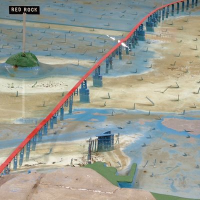
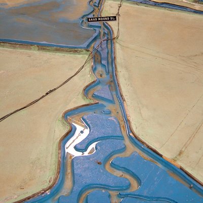
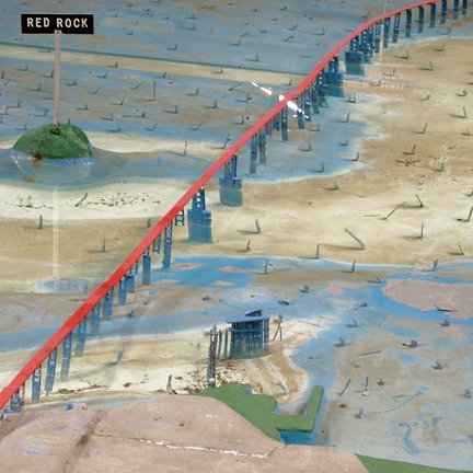
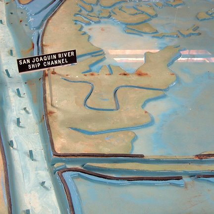
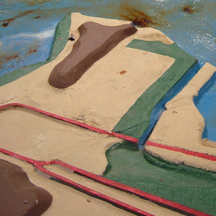
The Bay Model was built in 1957 by the Army Corps of Engineers; it is "over 1.5 acres in size and represents an area from the Pacific Ocean to Sacramento and Stockton, including: the San Francisco, San Pablo and Suisun Bays and a portion of the Sacramento-San Joaquin Delta." Which means it's larger than two American football fields. (I think).
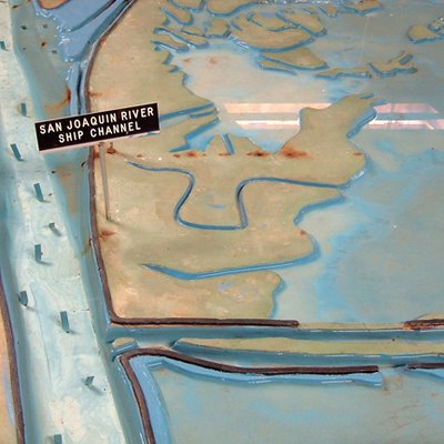
The Model served "as a scientific research tool from 1958-2000 to evaluate circulation and flow characteristics of the water within the estuary system," allowing Army Engineers "to simulate currents, tidal action, sediment movement and the mixing of fresh and salt water. Pollution, salt-water intrusion, barrier and fill studies were a few of the important research projects that have been undertaken at the Bay Model."
It's not in the greatest condition, and the faded primary color scheme leaves something to be desired, but the model is no less fascinating for that; any chance you get to walk the shores of a microcosm is a good chance to do some thinking.

If I may briefly quote William Blake –
Look closely and you'll see a "Tide Hut" where little gods of the Model enact catastrophe and unleash floods upon the surrogate world spread out before them. Look closer, and you'll see damage from a "hundred years of waves, subsidence, and boat wakes" – which, in Model time, is almost exactly one human year.
But I soon got to thinking about the politics of architectural models. Imagine what would happen, for instance, if some Navy SEALS raided a cave in Afghanistan and found the Bay Model sitting there: what on earth does al-Qaeda want with San Francisco's water supply? FOX News screams. Or a model of Greater London's Thames hydrology, complete with flood gates, Barriers and overflow sewers, which is one thing if it's in the possession of Tony Blair, and quite another if found in the basement of, say, Abu Hamza or even Timothy McVeigh.
What were they trying to do with it?
It's the politics of architectural models: an object of scientific curiosity in one person's hands is an issue of national security in another's.
Or: simulacra as a threat to national security.
A plot for a new Philip K. Dick novel, or a film by Charlie Kauffman, then came to mind: a man, perhaps a young Al Pacino, breaks into the Bay Model in the middle of the night. He barricades himself inside, turns on the power, and starts flooding the model, demolishing bridges, rerouting estuarial confluences. He jumps up and down, causing modelquakes, and then accelerates the tides, obliterating Golden Gate Park under the force of a single wave.
He calls all the local newspapers and takes responsibility for the disasters now befalling San Francisco outside; but what disasters? they ask, and he thinks they're conning him, denying his rage, because he's read William Blake and St. Thomas Aquinas and he believes that everything he throws at that simulacrum there before him will have effects in the real world...
Because it's all building up to one moment, see, the big moment when he decides to flood the Bay Model's model of the Bay Model, opening up a rift in the universe and blasting him head-first through the macrocosm.
Until the police break-in...
(Thanks to Chad for the tip, and to Nicola for coming with me!)
The Bay Model was built in 1957 by the Army Corps of Engineers; it is "over 1.5 acres in size and represents an area from the Pacific Ocean to Sacramento and Stockton, including: the San Francisco, San Pablo and Suisun Bays and a portion of the Sacramento-San Joaquin Delta." Which means it's larger than two American football fields. (I think).
The Model served "as a scientific research tool from 1958-2000 to evaluate circulation and flow characteristics of the water within the estuary system," allowing Army Engineers "to simulate currents, tidal action, sediment movement and the mixing of fresh and salt water. Pollution, salt-water intrusion, barrier and fill studies were a few of the important research projects that have been undertaken at the Bay Model."
It's not in the greatest condition, and the faded primary color scheme leaves something to be desired, but the model is no less fascinating for that; any chance you get to walk the shores of a microcosm is a good chance to do some thinking.
If I may briefly quote William Blake –
- To see a world in a grain of sand
And a heaven in a wild flower
Hold infinity in the palm of your hand
And eternity in an hour
Look closely and you'll see a "Tide Hut" where little gods of the Model enact catastrophe and unleash floods upon the surrogate world spread out before them. Look closer, and you'll see damage from a "hundred years of waves, subsidence, and boat wakes" – which, in Model time, is almost exactly one human year.

But I soon got to thinking about the politics of architectural models. Imagine what would happen, for instance, if some Navy SEALS raided a cave in Afghanistan and found the Bay Model sitting there: what on earth does al-Qaeda want with San Francisco's water supply? FOX News screams. Or a model of Greater London's Thames hydrology, complete with flood gates, Barriers and overflow sewers, which is one thing if it's in the possession of Tony Blair, and quite another if found in the basement of, say, Abu Hamza or even Timothy McVeigh.
What were they trying to do with it?
It's the politics of architectural models: an object of scientific curiosity in one person's hands is an issue of national security in another's.
Or: simulacra as a threat to national security.
A plot for a new Philip K. Dick novel, or a film by Charlie Kauffman, then came to mind: a man, perhaps a young Al Pacino, breaks into the Bay Model in the middle of the night. He barricades himself inside, turns on the power, and starts flooding the model, demolishing bridges, rerouting estuarial confluences. He jumps up and down, causing modelquakes, and then accelerates the tides, obliterating Golden Gate Park under the force of a single wave.
He calls all the local newspapers and takes responsibility for the disasters now befalling San Francisco outside; but what disasters? they ask, and he thinks they're conning him, denying his rage, because he's read William Blake and St. Thomas Aquinas and he believes that everything he throws at that simulacrum there before him will have effects in the real world...
Because it's all building up to one moment, see, the big moment when he decides to flood the Bay Model's model of the Bay Model, opening up a rift in the universe and blasting him head-first through the macrocosm.
Until the police break-in...
(Thanks to Chad for the tip, and to Nicola for coming with me!)


Comments are moderated.
If it's not spam, it will appear here shortly!
I remember seeing this years ago featured in an "Escape from Alcatraz" documentary on public television.
Its sounds like the Mississippi River model talked about on Virtual Globetrotting, includes Google Earth maps location + other formats.
BTW, your site is a joy, thanks for all the interesting posts.
"A 200 acre functional model of the entire Mississippi River drainage area, located on a field surrounded by forests, and now abandoned. Constructed by the Army Corps of Engineers to model the flow characteristics of the river, as part of the design process for their numerous flood control structures. Built in the late 1940's, initially using forced labor from a German POW camp established next to the site, and used last in the early 1980's, the model is in a public park, and is still owned by the Army Corps."
Virtual Globetrotting: 200 acre model of the Mississippi River
We managed to almost duplicate a couple of pictures. When I took my series, Red Rock and Point Isabel were two of the most interesting spots for me.
Here's an interesting link to a model of quatelmala--this reminded me of that. Not for research purposes, but apprently for tourism...
http://www.guate360.com/galeria/categories.php?cat_id=57
Post a Comment