
Islands of Total Cartography
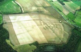
[Image: Archaeological traces on the surface of the Isle of Wight].
Islands are ideal testing grounds for the weird, the puzzling, the crazed – even the miraculous. The Biblical Book of Revelation, for instance, psycho-cinematically revealed itself to John in a dark grotto on the Greek island of Patmos.
But an island's spatial limitations also give it a kind of intellectual thrill: by limiting your territory for you, an island seems to promise total knowability. You could walk the whole thing, memorize every detail.
This, in part, may have been at least one motivation for an upcoming event in southern England, hosted on the Isle of Wight. There, New Scientist explains, "satellite mapping enthusiasts from all over Europe" – and beyond – hope to produce "a completely free digital map of the whole island. These high-tech cartographers will drive, cycle and ramble all over the island, using their GPS receivers to record the co-ordinates of roads, natural landmarks and points of interest. They'll use this data to create a completely digital map which will be available online to anyone." An entire island, digitized.
Check out their website if you'd like to get involved.
Meanwhile, a much more analogue example of this impulse toward total cartography comes to us from Ireland's Aran Islands, off the coast of County Clare.
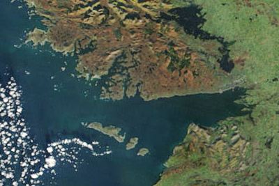
[Image: The Aran Islands].
There, a totally fascinating and almost impossibly ambitious example of modern cartography – a truly encyclopedic knowledge project – unfolded.
"In the summer of 1972," the Guardian tells us, a man, named Tim Robinson, "came from London to Árainn, the largest of the islands, to live." The living wasn't easy: "Big Atlantic storms, brief days, and 'an unprecedented sequence of deaths, mainly by drowning or by falls and exposure on the crags,'" almost forced Robinson and his wife to return to the city.
"But they stayed, and Robinson – a mathematician by training, an artist by vocation, and a draughtsman of skill – began to cast around for a way to respond creatively to the islands. So began one of the most sustained, intensive and imaginative studies of a landscape that has ever been carried out. Robinson conceived of a two-volume study of the islands – a local epic – which would be accompanied by a new map of the islands that he would survey and draw."
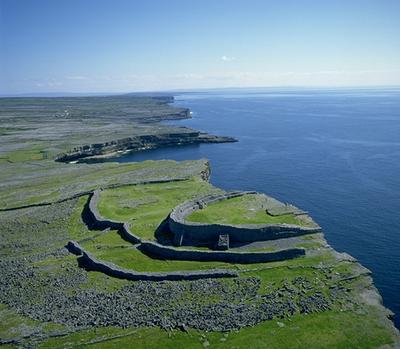
[Image: The Aran island of Dun Aonghasa; note, of course, that half the fort has crumbled into the sea].
Robinson mapped everything – the locations of buildings, what those buildings housed, who owned them, how often people visited, what their local history was, even what tectonic and mineral lineage the rocks themselves contained.
"Long before psychogeography became a modishly over-used and under-comprehended term," we read, "Robinson was out on the dérive – talking to the islanders, walking the rimrock, surveying, dreaming, recording. In bad weather, of which there was plenty, he would hold his notebook and pencil inside a clear plastic bag, tied shut at his wrists, and proceed in this manner: a deranged dowser wandering the mists and the storm-spray."
Robinson recorded "the deep entanglement of the human and the mineral" via "the fading mazes of the past."
"In exploring this terrain," Robinson wrote in volume one, which I read several years ago, "it is best to let oneself be led by its inbuilt directionality."
But pen and paper, along with superhuman energy, are not the only tools one needs in order to map every inch of an island. There is GPS, as we've seen – and there's also CCTV.
Surveillance.
Cartographic interests of a more Orwellian kind were tested on a small island off the coast of Maine a few years back. As Wired informed us in May 2004, "Ayers Island, the site of an abandoned paper and textile mill in Orono, Maine, will be spied upon by a comprehensive network of video cameras, motion detectors and sensors. Lurking behind all of those sensors will be an artificial intelligence system that will decide who can be trusted and who is deserving of greater scrutiny."
This will apparently prove "that AI, combined with ubiquitous sensors, may be able to provide civil authorities with comprehensive, real-time intelligence about the whereabouts of individuals and cars, and the status of buildings and other structures within a particular geographical area."
In other words, whether through surveillant videography, satellite mapping, deep local history, or even epic poetry, islands respond well to the cartographic impulses they themselves seem to inspire. Just look at The Odyssey.
(Earlier: The Island of New Ephemera. Gunkanjima Island).


Comments are moderated.
If it's not spam, it will appear here shortly!
Post a Comment