
New Maps of Impervious Surfaces
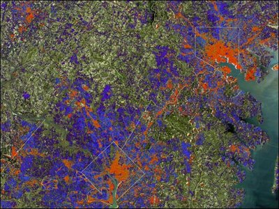
[Image: Apparently, "space-based maps of buildings and paved surfaces, such as roads and parking lots, which are impervious to water, can indicate where large amounts of storm water runs off." In other words, these new cartographic tools can be used to predict where urban flash floods might flow – hydrology at a distance. The map you're looking at, above, shows the Baltimore-Washington metropolitan area (in false-color). Here's a massive 4.2MB version. Courtesy NASA/Earth Observatory].


Comments are moderated.
If it's not spam, it will appear here shortly!
Post a Comment