
Tunnels, mines, and the "upwardly migrating void"
 [Image: Scotland Street Tunnel, Edinburgh, as photographed by Nick Catford].
It's always worth checking in to see what Subterranea Brittanica have been up to – especially when they've been to such places as the Hanover Chalk Mine or the Scotland Street Tunnel – so I thought I'd take a quick look at some of the things now up on their site.
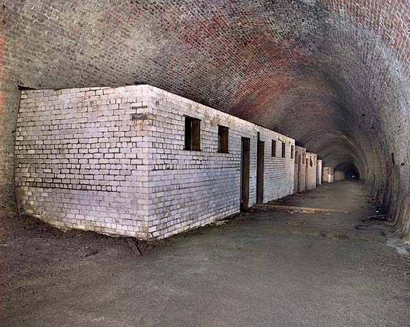
First of all, starting with the Scotland Street Tunnel, we find ourselves in Edinburgh, walking down through a former railroad tunnel that "measures 1000yds in length, 24ft in width, and 24ft in height with a gradient of 1-in-27 towards the north. The roof of the tunnel is just below street level at Scotland Street," they write, "but is 49 feet deep at St. Andrew Street and 37 feet deep under Princes Street."
 [Image: Scotland Street Tunnel, Edinburgh, as photographed by Nick Catford].
In their field notes, our guides at Subterranea Brittanica quote novelist Robert Louis Stevenson:
- The tunnel to the Scotland Street Station, the sight of the trains shooting out of its dark maw with the two guards upon the brake, the thought of its length and the many ponderous edifices and open thoroughfares above, were certainly of paramount impressiveness to a young mind.
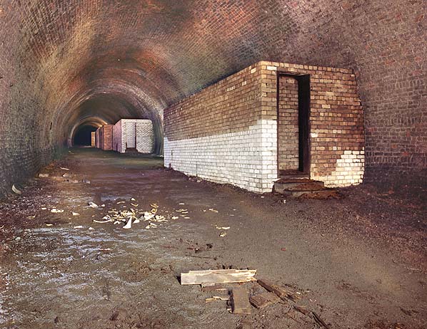
Post-war, then, the tunnel went on "to house... a traffic office with centralized traffic control. The traffic controller had telephone links to all signal cabins, goods yards and major stations and offices" in the city. This latter function partially explains the brick structures that were built inside the underground space.
Awesomely, we read, in the 1970s "the tunnel was used for growing mushrooms" – before it was then "used as a location for monitoring natural radiation."
Don't eat those mushrooms!
 [Image: Scotland Street Tunnel, Edinburgh, as photographed by Nick Catford].
Many more images of the tunnel – all of which were taken by Nick Catford – including a lot more information, can be found at the bottom of this page.
Meanwhile, there's the Hanover Chalk Mine in Reading, England.
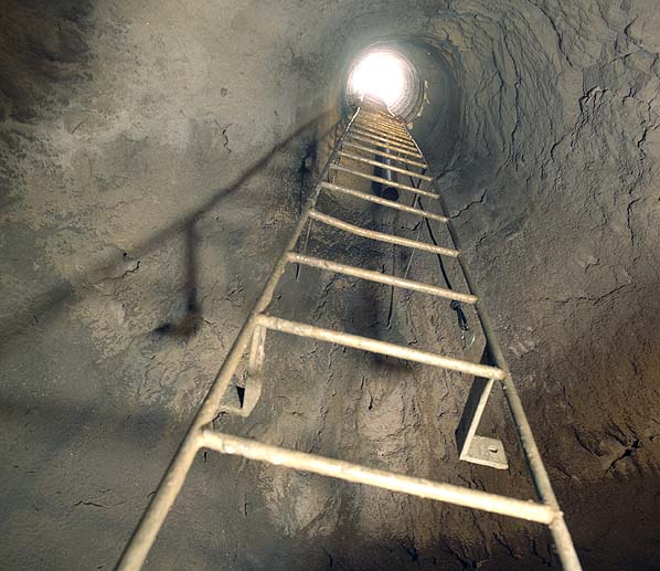
Access to the mine, we're told, can be "arranged via the [local] caving club." You physically enter the space by way of "a 50ft fixed steel ladder in a narrow vertical shaft below a locked iron cover."
In other words, you lift the iron cover – and descend into the surface of the earth.
 [Image: Hanover Chalk Mine, as photographed by Nick Catford].
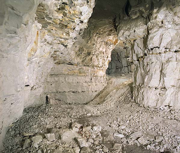
The Hanover Chalk Mine was apparently "rediscovered" in 1977, after which "a new lining was installed in the shaft, and the workings inspected and surveyed."
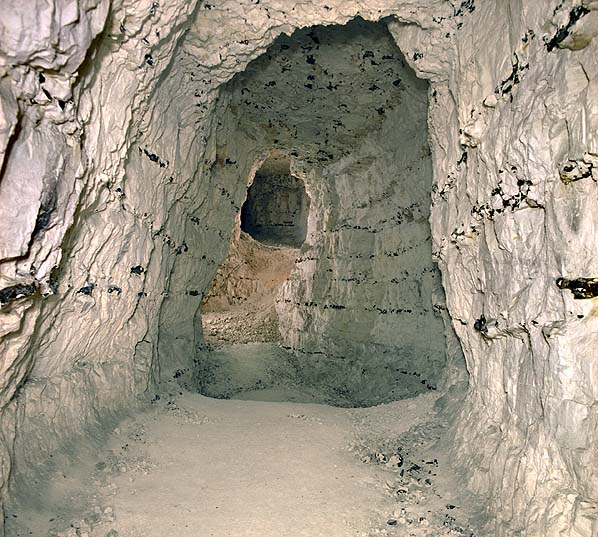
Subterranea Brittanica themselves found that the mine "is generally very dry, with no obvious evidence of water seeping in through the ceiling or standing on the floors."
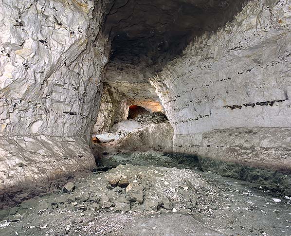
 [Image: Hanover Chalk Mine, as photographed by Nick Catford].
However, judging from small piles of rubble, some structural instability in the walls apparently relieved itself long ago through a partial collapse; this partial collapse is beautifully referred to as "an upwardly migrating void" that may yet cause "other collapses of the surface."
 [Image: Hanover Chalk Mine, as photographed by Nick Catford].
Though it's divided up into northern and southern branches, each excavated for slightly different purposes, the mine has not always been a mine.
"One or both of the interlinked northern mines," we read, "are known to have been used for the secure storage of documents by Reading Council during World War II, and two corrugated iron shelters, a brick-built stove and chimney, and tea-chests are said to remain below ground. One of the shafts reportedly contains timber staging, and one is said to be 70 feet deep."
So where did all this chalk come from?
In his fantastically great book Earth, writer and natural historian Richard Fortey takes us on an imaginary aerial tour of the planet, drifting in a full circle around the globe.
During the tour, Fortey describes how we look down from great heights at the vast folded belts of continental plates, from buckled ridges and alluvial plains to tropical islands, Himalayan plateaus, and Pacific trenches – including, at one point, the ancient chalk landscapes of southern England.
Quoting Richard Fortey at great length:
- Imagine flying higher and higher, until we can see that all the fine hotels and monuments and endless suburbs of London lie in a bowl of strata of Tertiary age. The River Thames is now no more than a silvery line following the centre of the bowl. Beneath these strata – mostly soft sands and clays – there are older rocks again; the white Cretaceous limestone known as the Chalk reaches the surface north and south of London on open downs, where sheep were once universal... South of the London Basin, the Chalk frames the Weald, which was the major source of iron in medieval times and now is thick with groves of sweet chestnut burying ancient hammer ponds. From high up, most of what you see is forested. Climb higher still and we can see that the Chalk, again, forms the white cliffs of Dover – to many English people perhaps the most sentimentally significant piece of geology there is. From this height we can see that the Dover cliffs are of a piece with facing cliffs in France on the other side of the English Channel, which is nothing more than a geological afterthought, breached by the eroding sea just a few thousand years ago. Geology knows no national boundaries and from here we can even make out the Chalk extending far across France, to underlie the endless plains in the north, where the grain that goes into making 100 million baguettes is grown in fields that have neither hedgerows nor apparently any end. And could we but follow the Chalk around the world we would find similar white limestones stretching from the Canadian Shield "all the way through to Texas and Mexico," as [Eduard] Suess said, to the Black Sea and well beyond in the Middle East. Chalk rock records one of the great transgressions of the sea onto the continents, one which happened close to 100 million years ago, and which painted great slabs of the world white for eternity with the sediment it left behind.
 [Image: Hanover Chalk Mine, as photographed by Nick Catford].
I think it's more important simply to point out that these rocks, seamed with flint, so ready to form caves and pockets beneath the everyday landscape we normally walk upon, thinking more often about what lies ahead than what lies below, have an incomprehensibly specific and ancient history behind them.
If it wasn't for lost seas, nearly saturated with life, slowly depositing meter upon meter of organic matter in quiet bays and inlets and coves, this chalk would never have formed – and, of course, this mine would never have existed.
These photographs thus capture the almost unimaginably distant side-effects of landscapes that no longer exist – side-effects which have themselves come to form landscapes, in fact the very terrain that grounds our present era.
The history beneath that ground is indeed a kind of abyss.
Finally, while you're clicking around through Subterranea Brittanica, don't miss the artificially underground surreality of Barons' Cave.
"Nobody knows how old The Barons' Cave is," we read. "The oldest reference to it dates from 1586 when Camden describes 'an extraordinary passage with a vaulted roof hewn with great labour out of the soft stone.'"
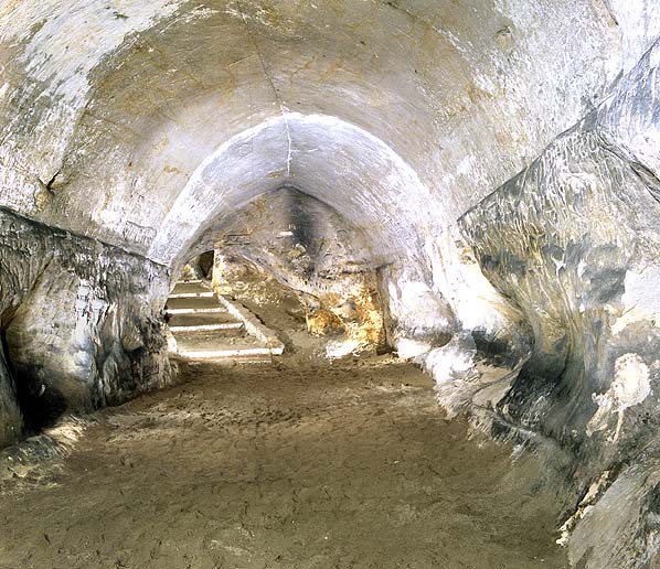 [Image: Barons' Cave, as photographed by Nick Catford].
The various photos of Barons' Cave are well worth checking out – including close-ups of graffiti left by visitors who missed one another by hundreds of years.
(All images in this post are by Nick Catford, who holds the copyrights, etc. etc., and deserves loads of credit for the amazing work).


Comments are moderated.
If it's not spam, it will appear here shortly!
i find it some sort of relief to hear about the mysteries of the Undeground, when most presume we know everything there is to know about the ground beneath our feet, since the surface of the earth has in some certain sense been mapped and, in particular, may be viewed in its entirety via satellite technology. So thank you.
For supremely interesting underground antics, do read Thomas Pynchon's latest, Against the Day, which contains many traces of Verne. In particular, Pynchon envisages the Under(ground/world) as a space and/or time and/or space-time which operates both indepently of and in conjunction with the surface simultaneously: at points he considers them as reflections of one another in our imperfect sphere and at others he views everything happening on the surface as occuring in real space (in the mathematical sense) and everything underground as in complex space. !because of this, intractable problems on the surface may only be solved by going underground!
On another note, Odessa, Ukraine was built of limestone mined around the city so there are catacombs all around the place. these create a giant labyrinth (i don't know if it is connected; i doubt) which was most famously inhabited by those resisting the Nazis during WWII. The point being people inhabited the place previously taken by the stone underground while others literally lived inside the stone in the form of houses above the stone. Wierdly enough, Odessa is not just a city name, it is also an acronym for Organisation der ehemaligen SS-Angehörigen, or "Organization of Former SS-Members".
Post a Comment