
Fossil Rivers
 [Image: A page from Blend, a Dutch magazine for whom this post was originally written, back in September 2006; if the tone of this post feels like an article, that's why].
The geological history of the Mississippi River has been extensively documented by the U.S. Army Corps of Engineers for more than a century. The Corps has produced maps, charts, graphs, and illustrated reports. Taken together, these offer a snapshot of the Mississippi, from source to sea, including the river's "subsurface conditions," its ancient geological forms, and its present-day urban surroundings. We see the grids of existing cities – New Orleans, Baton Rouge, St. Louis – built upon the shores of the world's fourth-largest river; and we see remnant landscapes of eroded bedrock from a time before humans ever set foot upon North America. This is the "ancestral" Mississippi, a lost waterscape of "meander belts" and "alluvial aprons," now visible only to the eyes of trained geologists.
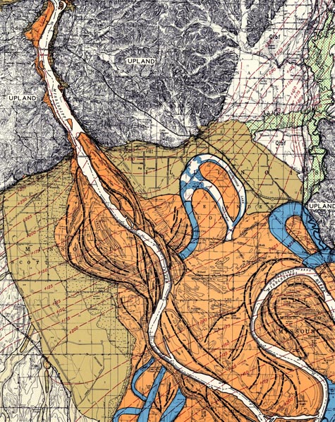 [Image: The Mississippi River in its geological context, as mapped by the Army Corps of Engineers. Worth viewing bigger].
Luckily, if geology bores you, the Corps’s maps are visually spectacular – beautiful to the point of near disbelief. Colors coil round other colors; abstract shapes knot, circle, and extend like Christmas gift ribbons. This is geology as a subset of Abstract Expressionism: rocky loops of the Earth’s surface in the hands of Jackson Pollock.
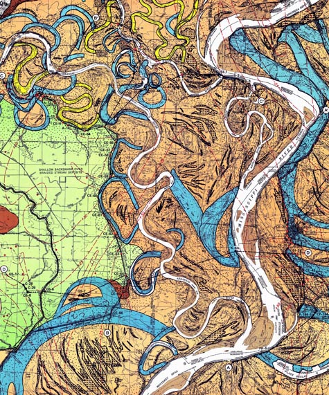 [Image: The Mississippi and its ancient side-routes; mapped by the Army Corps of Engineers. For a browser-crashing, eye-popping, dorm room-decorating, huge version, click here! Beware heart attack! Don't do while driving!].
In the maps, different colors represent routes of the Mississippi as recorded by the Corps at "approximate half-century intervals" – indeed, the river can shift that much, tracing whole new geometries in less than a century. In some maps not included here, for instance, this rate of change grows more extreme. We glimpse the Mississippi in its true historic dimensions, where it becomes a labyrinth of conflicting riverbeds, each one disappearing slowly, inevitably, over thousands of years, only to be replaced, abruptly, by new directions and forms – that will themselves disappear later.
These maps document time, in other words, as much as they document geography.
 [Image: The Mississippi, beautifully – even sublimely – mapped by the Army Corps of Engineers; view larger!].
The sheer fact that cities have been built in the midst of this mobile terrain is either horrifying or vaguely hilarious. The "land" all these cities are constructed on is actually hundreds of thousands of acres of displaced mud, thick sheets of soil washed down from the north and compacted over time into something approximating solid ground.
But there is no solid ground here: it is an unstructured mush of erased landscapes, a syrupy blur. The river meanders, creating surface here, surface there – solidity nowhere. The waters curve eastward, then westward, then back again, redesigning the central landscape of the United States, draining North America.
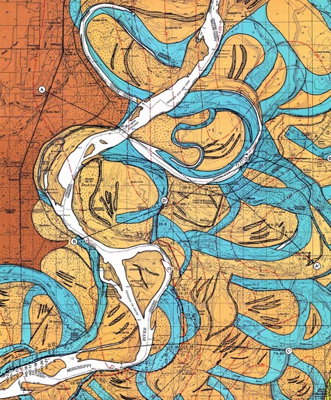
 [Image: The Mississippi as mapped by the Army Corps of Engineers; see bigger!].
Indeed, what the Army Corps of Engineers discovered while producing these maps is that the Mississippi River has changed channel completely – and it has done this hundreds, even thousands, of times. In fact, the river's endless self-alteration still occurs, even as you read these words: the Mississippi, like all rivers, is migratory, destined to wander across the landscape for as long as it continues to flow. It drifts back and forth – sometimes a few feet, sometimes a mile – walled in by its own silt and debris; until there is change: a natural levee fails, or a storm surge bursts into another watercourse nearby, and then the river finds itself on a quick new route to the sea.
These old routes, of course, leave traces: eroded deep into the rock and soil, or piled high in distant mounds, running across the backyards of farmers, forming ponds, they are the fossils of ancient landscapes – lost rivers locked in the ground around us.
 [Image: Lost sub-rivers of the Mississippi, in a region called Onward, mapped by the Army Corps of Engineers; view this bigger!].
If you are the Army Corps of Engineers, however – a branch of the U.S. military – then your mandate is to secure the nation’s waterways. The Mississippi’s relentless change in shape and direction is thus not a topic for poetry but a matter of national security.
Through their infinite encyclopedia of the river – constantly updated, never complete – the Corps hopes to control these riverine transformations. Their goal is made almost comically obvious when you note that these maps are printed by the “War Department.”
This is a battle strategy: it is geomorphic warfare.
Simultaneous with the realization that the Mississippi is a landscape on the move, the Army Corps of Engineers launched a much larger project, and that was to fix the path of the Mississippi in place – forever. It sought to do this through architecture, installing monumental locks and dams up and down the river’s route, controlling rates of flow, sediment, ship traffic, flash floods, and so on. For thousands of miles, then, the Mississippi would be a landscape held literally under martial law.
 [Image: The Mississippi as mapped by the Army Corps of Engineers; check out the big version].
This is sheer folly for anyone who looks at the Corps's own maps. Meadows and hillsides once located hundreds of miles away have been reduced to nothing but mud braided on the bottom of the Mississippi River, clumped high in deltas, spread wide over lobes upon which whole towns have now been built.
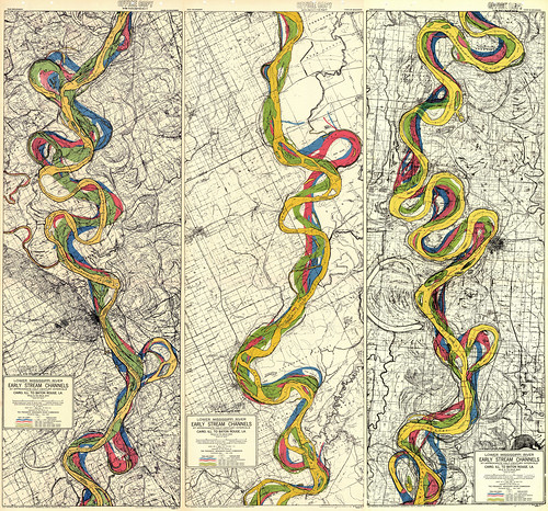 [Image: Early stream channels of the Mississippi, geologically charted by the Army Corps of Engineers; view it larger and freak out].
But someday even the Corps’s pharaonic locks and dams will be mere sand on the shores of a future Mississippi. All these misguided control structures – and the cities they protect – will disappear, glittering in the currents like Rhinegold... before they, too, are lost to the river forever.
(Note: I'm hugely endebted to Alex Trevi, of Pruned, without whom I would not have seen these maps when I did... and this article would thus never have been written. In fact, if you squint, and lean in close to the monitor, you'll notice that I thank him in the original article, reproduced above. In any case, if you like what you see here, don't miss Alex's own investigation of this subject matter!).


Comments are moderated.
If it's not spam, it will appear here shortly!
pollack?
as that haw ya spall jacksan pallack?
A spall at wath an O.
Empirical evidence that we are indeed one nation under FSM.
Whoops - fixed the Pollock.
Yes! I love appropriating scientific technical things as aesthetic objects!
freakin' awesome
Thanks for these links
if you haven't...you should check out _The Map That Changed the World: William Smith and the Birth of Modern Geology_ by Simon Winchester.
Incredible Maps! Anyone interested in the Army Corps struggles to control the Mississippi River (Pre- Katrina) should check out John McPhee's The Control of Nature- it's a pretty amazing read.
These images remind me of the beauty and horror of the anatomical illustrations for Vesalius. Thanks for posting these.
so alluvially organic they're beautiful. thkx 4 sharing!
Anyone have a source to buy these maps in large format, decorative art style?
The last map is the most exquisite. The river reminds me of Mucha's smoke lines. I second the request for purchasing a large format poster!
Post a Comment