
Hot-Mapping the UK, or: Spy Planes Over Haringey
Earlier this year it was reported that the London borough of Haringey had used a spy plane to record residents' energy use patterns: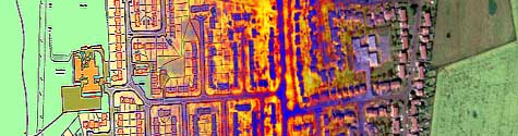 More specifically:
 The practice itself is referred to as "hot-mapping," and the company behind the Haringey project also has "complete aerial heat-loss data sets of most of London and all of Norwich. Other locations may follow, and specific areas can always be commissioned."
What's interesting, though, is that the use of a "spy plane" – really, just an airplane – makes the whole thing sound like some sort of Gestapo-esque invasion of privacy; one wonders if the Haringey heat-map would have generated quite as much negative commentary if it had used, say, random satellite maps or even a house-by-house home inspection team.
Though, having said that, I'm reminded of a story I heard on NPR a few months ago, about chimney sweeps in Germany and how they're still considered somewhat suspicious due to their historical use, by the Stasi, as domestic spies during the good old days of the DDR.
All of which is just a long way of saying: is it possible to monitor and regulate something like domestic home energy-use without tripping off people's sense of being targeted by The Man – some terrifying and abstract Big Government that sends agents to your home and fills the sky with spy planes? Does the very mention of the phrase "spy plane" lead to resentment and paranoia?
(Story spotted at collision detection).
- Thermal images of homes have been taken by a light aircraft fitted with military spy technology to record the heat escaping from people’s houses.
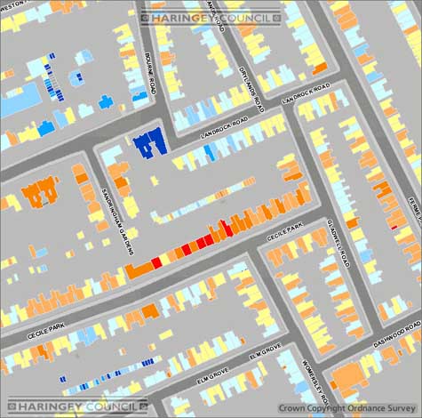
Maps identifying individual homes have now been placed on the internet to encourage occupiers to reduce their wastage and carbon emissions by fitting insulation and turning the thermostat down.
More specifically:- An aircraft, fitted with a military-style thermal imager, flew over the borough 17 times to take pictures of almost every house in the area.
Footage of heat loss was converted into stills, then laid over a map of the area, before each house was given colour-coded ratings.
Homes that were losing the most heat were represented as bright red on the map. The least wasteful households were shown in deep blue. Shades of paler blues and reds were used to show grades of heat loss.
The practice itself is referred to as "hot-mapping," and the company behind the Haringey project also has "complete aerial heat-loss data sets of most of London and all of Norwich. Other locations may follow, and specific areas can always be commissioned."What's interesting, though, is that the use of a "spy plane" – really, just an airplane – makes the whole thing sound like some sort of Gestapo-esque invasion of privacy; one wonders if the Haringey heat-map would have generated quite as much negative commentary if it had used, say, random satellite maps or even a house-by-house home inspection team.
Though, having said that, I'm reminded of a story I heard on NPR a few months ago, about chimney sweeps in Germany and how they're still considered somewhat suspicious due to their historical use, by the Stasi, as domestic spies during the good old days of the DDR.
All of which is just a long way of saying: is it possible to monitor and regulate something like domestic home energy-use without tripping off people's sense of being targeted by The Man – some terrifying and abstract Big Government that sends agents to your home and fills the sky with spy planes? Does the very mention of the phrase "spy plane" lead to resentment and paranoia?
(Story spotted at collision detection).


Comments are moderated.
If it's not spam, it will appear here shortly!
Indoor marijuana cultivation is also something they could look for with this technique. Could they map out every grow op in the UK suburbs with this I wonder. See the documentary Stoned in Suburbia for how prevalent they are.
Thankfully the use of such imagery in US criminal cases without first obtaining & serving a search warrant was prohibited by the Supreme Court case Kyllo v. United States,
http://www.law.cornell.edu/supct/html/99-8508.ZS.html
"All of which is just a long way of saying: is it possible to monitor and regulate something like domestic home energy-use without tripping off people's sense of being targeted by The Man – some terrifying and abstract Big Government that sends agents to your home and fills the sky with spy planes? Does the very mention of the phrase "spy plane" lead to resentment and paranoia?"
Britain is the most surveilled nation on Earth and middle England still demands more.
Why is monitoring the only option ? Proper pricing and incentives can achieve the same result without surveillance or, incidentally, the carbon footprint of a small plane.
Pricing & incentives are less effective when the person who pays for the energy is different that the person who would pay for any structural improvements.
Landlord / renter.
Additionally, I suspect many on the 'hot list' have become used to high prices, and don't know the benefits.
a lower-tech version of hot-mapping has been used by the Rotterdam police in the past - whenever it snowed, a police helicopter would take off and fly the city. roofs with no snow were marked suspicious and seized by the police (after checking with power companies for unusually high electricity bills).
the dutch crime prevention center actually suggests looking for melting snow when you are out on a vigilante mission for weedbusting.
Wow, no one is actually interested in what the maps hows about energy use, just some frankly bogus arguments about privacy? As for captain Ned, what abut Google maps? What's the different, out of interest?
Hey, i can see my house from here! Even despite living in Islington rather than Haringey.
Apparently, we're the lightest shade of blue, so about middling in temperature. Which surprises me, given how huge our last heating bill was.
Two problems i can see here. Firstly, this doesn't account for convective heat losses, due to draughty windows and such, or, i think, radiative heat losses that go sideways - if we had a thoroughly-insulated loft but large, leaky single-glazed windows spewing heat into the night, we'd show up as cool on this map. In fact, we do and we do.
Secondly, this doesn't account for houses with separate layers. Our building is two houses knocked together and converted into three flats, one on each floor. We're on the top floor, so that heat signature is us; the other two flats can't be seen through us, so this is no use to them.
Still, it's cool.
-- tom
Post a Comment