
Quick List 11
 [Image: A sketch by Henry Wood, from The New York Times].
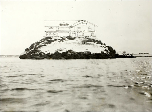
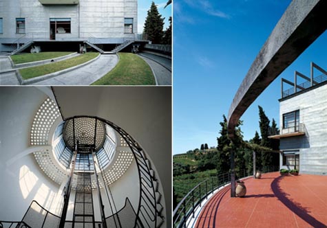
Last week, The New York Times took readers to an isolated house called Clingstone, built by a Philadelphian named J.S. Lovering Wharton on a rock in the waters of Rhode Island.
- Working with an artist, William Trost Richards, Mr. Wharton designed a shingle-style house of picture windows, with 23 rooms on three stories radiating off a vast central hall; its plan is less a blueprint than a diagram of arrows indicating sightlines.
He built it like a mill, Mr. Wood said, with wide planking, sturdy oak beams, diagonal sheathing and an odd flourish: an interior cladding of shingles...
"This house is always going to have rough edges,” says current resident Henry Wood, an architect.

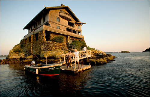
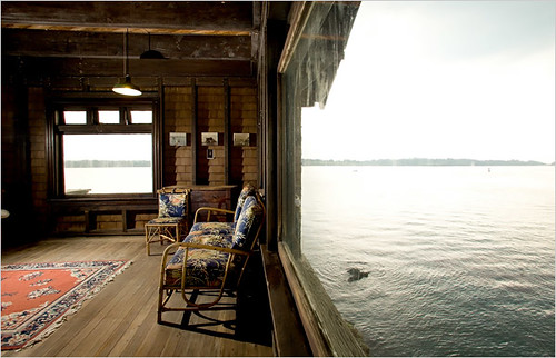 [Image: Photos by Erik Jacobs for The New York Times].
The house, an act of near-constant maintenance, is now on its way to being green:
- Today, solar panels heat the water, and a wind turbine on the roof generates electricity. Rainwater is collected in a 3,000-gallon cistern, then filtered, treated and pumped through the house for cleaning purposes. (Mr. Wood claims it is safe enough to drink, “but my children don’t trust me so we don’t,” he said.) After years of using an activated seawater system that draws in seawater, then treats and filters the waste before releasing it back into the ocean, Clingstone now has the latest generation of composting toilets.
The slideshow, with images by Erik Jacobs, is worth checking out.
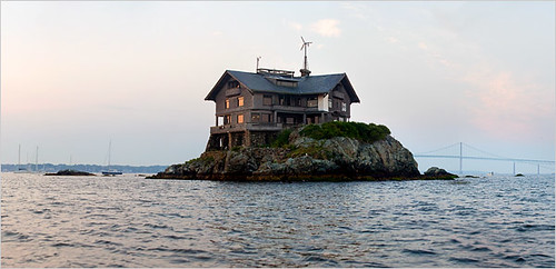 [Image: Note the wind turbine. Photo by Erik Jacobs for The New York Times].
Meanwhile, over at Deputy Dog we were introduced to the rotating architecture of the Villa Girasole, a house in Italy that rotates on massing internal roller bearings and exposed tracks paved into the landscape.
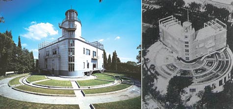
 [Images: The Villa Girasole, from Deputy Dog, thanks to a link from Marilyn Terrell].
The house, by engineer Angelo Invernizzi, "last rotated in 2002," we read in Chad Randl's new book Revolving Architecture, where many more photographs of the building appear. Randl writes:
- Invernizzi and his design team used the villa project as a laboratory for trying out modern materials, from reinforced concrete to fiber-cement wall boards. In keeping with the project's experimental nature, a considerable amount of adaptation and refinement accompanied construction. On the exterior walls Invernizzi substituted aluminum sheet for the original cement finish when cracks appeared after the first trial rotations. As the foundation settled and the rotating mechanism was tested, small cracks also developed along the interior plaster walls of the moving part. Invernizzi concealed the damage by finishing the walls with a canvas covering...
You can read more about the house's "rotational machinery" in Randl's book.
I wonder, though, if an interesting children's novel couldn't someday be written about a family who goes off on holiday for the summer in the mountains of Italy, renting a dust-covered and slightly eccentric old house. The young boy or girl, who is left alone all day, for whatever reason the novelist comes up with, finds a small panel one day in the house's towering attics.
Those strange paths in the garden, you see, aren't just paths, they're tracks – and this house doesn't just rotate it travels large distances...
 [Image: An under-detailed simulated glimpse of "subterranean cyclones"].
In any case, in a bit of unrelated news, hurricanes of liquid iron have been raging at the earth's core for more than 300 million years, simulations suggest. These "subterranean cyclones" have been spinning for the most part below Asia, perhaps explaining the core's seismic asymmetry.
 [Image: A new Los Angeles park, rendered by EDAW; spotted at Inhabitat].
Earlier this summer, EDAW released images from its intern design program wherein a new park atop a buried freeway for Los Angeles was the featured subject of discussion. Park 101, as they call it, would be the resulting swatch of artificial land created by covering up the 101 Hollywood freeway. EDAW describes its own plan as "a visionary, and realistic, urban design solution to cap... a relatively small area straddling the 101 freeway, situated in an existing maze of roadways." It will be "an iconic urban park in the heart of downtown Los Angeles... re-visioning the existing infrastructure that supports and encircles the core of the city – freeways, channelized rivers, streets, and public transit."
Considering that L.A. needs very seriously to consider pedestrianization plans, at a huge variety of scales across the whole city, this seems like as good a place as any to begin.
In fact, BLDGBLOG here proposes something like a Pasadena-to-Pacific walking trail: a purpose-built pedestrian boulevard – car-free its whole length, except perhaps for access to emergency services – leading from the beaches of Santa Monica all the way to the foothills of Pasadena, via Griffith Park, encompassing de-paved sections of major cross-city thoroughfares.
A north-south axis would be soon to follow – and the whole thing could perhaps then hook up with the Pacific Crest Trail.
 [Image: From some things we made together (on the 405 south) by Sean Dockray].
 Speaking of L.A., in response to the previous post, artist Sean Dockray sent in these unexplained images, apparently derived from "freeway loop detector data" on the perpetually clogged 405. We've covered Dockray's work before; in this case, Dockray also drops hints about "a radio station that would be nothing but a reading of [traffic] incidents around [Los Angeles] county (w background music)."
So what do these subtly morphing diagrams really mean?
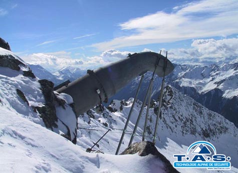 [Image: Gazex, via anti-avalanche technology].
 Finally, Pruned was Alps-bound last week with this look at Gazex, an "explosively effective" anti-avalanche technology embedded in the snow-covered mountainsides.
According to the company's own website, "Gazex explodes an oxygen/propane gas mixture in specifically designed exploder tubes located at the top end of risk zones. The exploders are connected to gas storage tanks with capacities high enough to operate for the whole season without re-filling."
The company boasts that it is the "world leader in remote avalanche prevention control systems."
Clearly, though, it would not be hard to re-purpose this technology, installing hundreds – thousands – of these things in the mountains, anticipating warfare... and then hurling avalanches down upon the heads of invading armies.


Comments are moderated.
If it's not spam, it will appear here shortly!
My first thought on seeing the Gazex was: "Oh, they've added another endpoint to the Telectroscope!"
Not sure if you're aware, but there's a precedent for your last suggestion. In the Tyrolean campaign of WWI, Austrian and Italian fired shells and so on at mountains above each others positions. About 60,000 troops were killed by avalanches, whether natural or manmade. There's more here. Pretty grim.
Michael, I wrote a little bit about the architecture of that conflict in an earlier post: The Bridged Architecture of Adjacent Peaks. The remnant structures of Alpine war are pretty fascinating, I have to say.
And, John, thanks for the reminder of the Telectroscope!
Well, read the linked article through and realised it directly disagreed with the point I was trying to make. Ho hum...
This listing quotes it as fact. BBC claimed the same, on a popscience show a few months back.
Maybe they were classified... You gotta love the idea of Top Secret Landscape Events.
The rotating house story is fantastic, and seems tailor made for an episode of Lost.
At Clingstone, the cladding of both sides of all the interior walls with cedar shingles is also a well-adapted response to the local climate.
In a place that is inevitably exposed to moisture, salt, temperature extremes, and pummeling from the constant winds, plaster walls would not have lasted more than a couple of winters... During the house's 20 years of abandonment, when almost the entire structure was exposed to the exterior elements, the shingles protected the interior walls from disintegrating.
It's awesome to see the house featured here!
mesmerizing..
thanks for sharing !
ciao zoe tati
Dockray's images are rather intriguing. The names of the image files clearly indicate that each image is from a single day, those days running in sequence from the 1st of February to the 30th of May 2006. The fact that they're are organised into rows of seven is thus no coincidence - each row is a week, with the the fourth and fifth figures in each row being the weekend.
I assume that each figure is a radial plot, with angle being time, and the distributions of bands somehow indicating activity of some sort. I'd guess that the angles are like a 24-hour clockface, with midnight at the top, which would put the twin bulges on the bottom half of most figures at around nine and five, ie rush hour. These bulges are notably absent from the weekend figures.
The interesting bits are the exceptions. Why is there only a partial figure on the 1st of March and 2nd of April? What on earth happened on the afternoon of Sunday 26th of February that led to such a colossal traffic spike? Whatever it was, it seems to have led to a lot of traffic on the following monday, too. Why was nothing happening on the Mondays of the 20th of February, 1st of May, and 29th of May? Why was the morning of the 21st of February so unusual? What happened at lunchtime on the 18th of April?
Just to add to the Tyrolean campaigns and avalanches being deliberately set off to kill the enemy during WW2, there is CATEGORICALLY nothing classified or "Top Secret" about that tactic.
There are numerous museums in Europe with photographs and filmed archive evidence of the tactic, and memorials to the dead, and as Michael said the BBC in the UK recently aired a series about the power of nature and included archived filmed footage of the deliberate setting off of avalanches by artillery onto the enemy during the above conflict.
Post a Comment