
Earthquakes on Street View
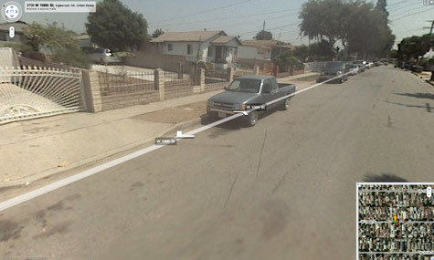 [Image: A 5.0 earthquake his Los Angeles less than an hour ago – and the epicenter can be seen on Google Street View].
A
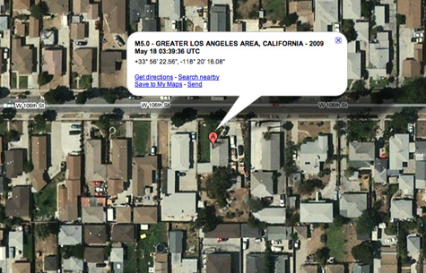 [Image: The semi-suburban origins of a seismic event].
The U.S. Geological Service gives us a Google Maps option for viewing tonight's earthquake reports, but what's extraordinary is that you can zoom all the way down to the urban surface to see that this earthquake actually had an address: it was epicentered at 3706 W. 106th Street.
Perhaps you could even send it postcards.
Imagine, though, owning the building centered directly over the earthquake that destroys your whole city... And imagine the weird derived value such a property might hold in the future for disaster enthusiasts.
You go to purchase a small house at 3706 W. 106th Street in Los Angeles – only to find that you've been outbid, by several orders of magnitude, approaching $50 million, by an earthquake enthusiast in Japan. He or she has gone around the world purchasing epicenters, strange plots of land in the middle of nowhere that have no apparent use or distinction other than that they figure into the unfolding seismic history of our planet's surface.
It's an otherwise unknown subculture that has remained camouflaged within the international property market.


Comments are moderated.
If it's not spam, it will appear here shortly!
I find this scenario all to easy to believe! Some people will collect anything...
Felt it, albeit mildly, in Silver Lake.
How could an epicenter be so small? Surely the enthusiast would have to buy the entire street.
Adam: The epicenter is a point, not a zone. It's the location of the center of the shaking. So, for example, if the shaking took place on a straight line, the midpoint of that line would be the epicenter.
I have a blog all about this involving google images and earthquakes.
http://didyoufeelit.blogspot.com/
There is a Twitter bot that adds Google Maps to the USGS info.
http://twitter.com/earthquakesLA
Wonder when a actual earthquakes gonna be captured by googles cameras!
Here´s a twitter feed with automatic updates of Icelandic earthquakes - with links to google maps: twitter.com/jardskjalftar
Post a Comment