
IceLink / Land Bridge / Yesterday
 [Image: From "IceLink: Occupying the Temporal Seam" by Lateral Office].
In their submission to the recent competition to design a bridge across the Bering Strait – the Bering Strait Connection – Toronto's Lateral Office proposed "IceLink: Occupying the Temporal Seam."
Lateral Office, of course, are also the brains behind the excellent blog InfraNet Lab, as well as the designers of both the Air Unit and the awesome Runways to Greenways plan proposed for Iceland – and IceLink is no less interesting than either of those.
 [Image: From IceLink by Lateral Office].
First, for those of you who did not see the original call for projects, the Bering Strait Connection described itself as a "project attempting to connect two continents":
- In a wide sense, it includes building a tunnel or a bridge at both ends of the strait, extending [the] existing railways of the United States and Russia, and laying a world highway around the coasts of the world, which requires a massive amount of construction.
 [Image: From IceLink by Lateral Office].
In response to this, then, Lateral proposed: "1) a tunnel/bridge hybrid that runs along the international date line and accumulates diplomatic programs, and 2) a seasonal ice park that harvests ice floes into a global water vault."
A global water vault: it's ideas like this that make me love architecture.
 [Image: From IceLink by Lateral Office].
So the site, of course, would straddle two very different timezones: that is, both today and tomorrow (or today and yesterday). If I wasn't living in a temporary apartment right now, and thus without access to my books, I would quote from Umberto Eco's intellectually pessimistic novel The Island of the Day Before. There, we read how a shipwrecked scientist repeatedly fails to come to grips with the temporal (and epistemological) fact of his maritime abandonment along the international date line.
But, perhaps to the benefit of my readers, I can't.
Instead, let me also mention The Cryptographer, a novel by Tobias Hill. While it would be hard actually to recommend the book, it's nonetheless worth mentioning Hill's use of the international date line as an origin point for a currency-destroying computer virus: the Date Line Virus. Hill's Date Line Virus spreads westward with the ticking of the clock – or the turning of the earth – erasing digital savings and scrambling all systems of measured economic value.
That is, the world's entirely computer-based monetary system, hour by hour, goes mad.
Clearly, then, from even only these two examples, the narrative possibilities – and intellectual stakes – of the international date line are fairly interesting to draw on. Or, for instance, check out this factoid, from that well-known source of scientific accuracy, Wikipedia:
- For two hours every day, at UTC 10:00–11:59, there are actually three different days observed at the same time. At UTC time Thursday 10:15, for example, it is Wednesday 23:15 in Samoa, which is eleven hours behind UTC, and it is Friday 00:15 in Kiritimati (separated from Samoa by the IDL), which is fourteen hours ahead of UTC. For the first hour (UTC 10:00–10:59), this phenomenon affects inhabited territories, whereas during the second hour (UTC 11:00–11:59) it only affects an uninhabited maritime time zone twelve hours behind UTC.
But what about the spatial possibilities of the international date line?
How can this strange temporal fissure in the planet's political and cultural landscape be taken advantage of architecturally?
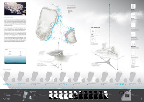
 [Image: From IceLink by Lateral Office].
IceLink, its designers write, without much surprise, "seeks to capitalize and highlight [the Strait's] unique geography, climate, and context." However, they add, "The intent here is less to impose a new landscape in this context than to emphasize the sublime conditions already existing. Currently, the Bering Strait is a seasonal barometer of the impacts of climate change. The intent with this scheme is to offer spaces with which to reflect on the correlation between natural environments and their occupation."
This is where we come to the project's "two primary infrastructural elements: a tunnel-bridge link and an ice park."
 [Image: From IceLink by Lateral Office].
The so-called "Bering Link" half of the project would consist of "bundled infrastructures," the architects explain; these infrastructures would span a distance of 85km, from Dezhnev, Russia, to Wales, Alaska. In the process, the Bering Link would skirt the Diomede islands, and even travel north-south atop the date line for 4km.
Alongside this would be a series of new buildings, "concurrent with the international date line."
- Public and cultural programs intermittently rise above the bridge while research and education programs hang below the rail/road. Significant programs include a new United Nations headquarters, World Water Council headquarters, an Arctic Museum, and extensive oceanographic and meteorological facilities.
Why?
Here we come to the second half of Lateral's project: the "Bering Ice Park," a kind of floating archive and index of global climate change:
- Sea ice is often trapped between the Diomedes prior to drifting northward. The new park seeks to enhance and highlight this phenomenon. The Bering Ice Park will cultivate, collect and distribute ice floes. The extent of the park is defined by the Diomedes coastlines facing the international border and date line as well as natural ocean currents movement north.
As it happens: no. The project described here did not manage to find a place amongst the finalists of the design competition.
To see what did make the cut, take a look at the results over at Bustler.


Comments are moderated.
If it's not spam, it will appear here shortly!
Perhaps it's silly, but this lovely thing inspired my Friday writing exercise at Ficly: "Night on the IceLink" http://ficly.com/stories/2473
It's always stunning to see how sometimes the geographical factor and the political mix so that one cannot distinguish them separately anymore... well, a truly geopolitical project...
Post a Comment