
Biology at the Border: An Interview with Alison Bashford
 [Image: Thermal scanners at the Seoul international airport; photo by Jung Yeon-Je for Reuters, via Time].
Alison Bashford is Visiting Chair of Australian Studies at Harvard University’s Department of the History of Science, as well as Associate Professor of History at the University of Sydney. Her work has examined the politics, culture, and spaces of quarantine at a variety scales, from immigration law and geopolitics to the design of nineteenth-century hospitals. She is the author of Imperial Hygiene: A Critical History of Colonialism, Nationalism and Public Health, and co-editor of both Contagion: Historical and Cultural Studies and Medicine At The Border: Disease, Globalization and Security, 1850 to the Present.
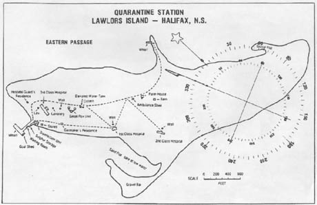 [Image: Map of Lawlor Island Quarantine Station, showing 1st and 2nd Class accommodation].
As part of our ongoing series of quarantine-themed interviews, Nicola Twilley of Edible Geography and I spoke to Bashford about the ways in which quarantine can both define and blur borders, the use of vaccination scars as health passports, and quarantine's role in enforcing social hierarchy and racial prejudice.
Edible Geography: To start with, how did you become interested in quarantine?
Alison Bashford: I got to quarantine through my early work on the concepts of purity and pollution. My first book, Purity and Pollution, was about how ideas about clean and dirty spaces and clean and dirty bodies, and the separation between them, came into being in the nineteenth century in the context of hospitals, and the discovery of germs, and so forth. After that first book, I started studying infectious disease management on a larger scale. I fairly quickly moved into looking at maps of early quarantine stations and the division of pure and polluted spaces there, as well as the various diseases that were managed that way.
My work is not always focused on Australia, but I quickly realized there was quite a particular Australian history to be sorted through here. Many diseases that have been endemic and epidemic in other parts of the world, such as cholera, never even arrived in Australia. In Australia, the quarantining of the entire continent came to be important in terms of keeping diseases out, but it was also symbolically incredibly important as part of the project of producing White Australia. I gradually realized what a rich history there was in terms of thinking about the racializing of the new nation in 1901 as, essentially, a public health project.
After that, I became very interested in island spaces as well—places where people with various diseases were quarantined in a much more permanent way. Amusingly, I live right next to the quarantine station in Manly. I’d written about quarantine for a long time—long before I lived there—and it’s just been terrific, living on the place that I was writing about for so many years.

 [Images: (top) The North Head Quarantine Station, Manly, Australia; photo by Nicola Twilley. (bottom) Spa treatment at Q-Station hotel retreat, Manly, Australia].
Edible Geography: It’s interesting what they’ve done to the quarantine station at Manly, in terms of turning it into a luxury hotel. The afterlife of quarantine stations is a fascinating topic in and of itself.
Bashford: Yes, absolutely. The developer gave me a good tour around it just before it opened. It was extraordinary listening to him talk about the concept of putting a day spa on the site of the old hospital buildings, which is where the most infected were kept.
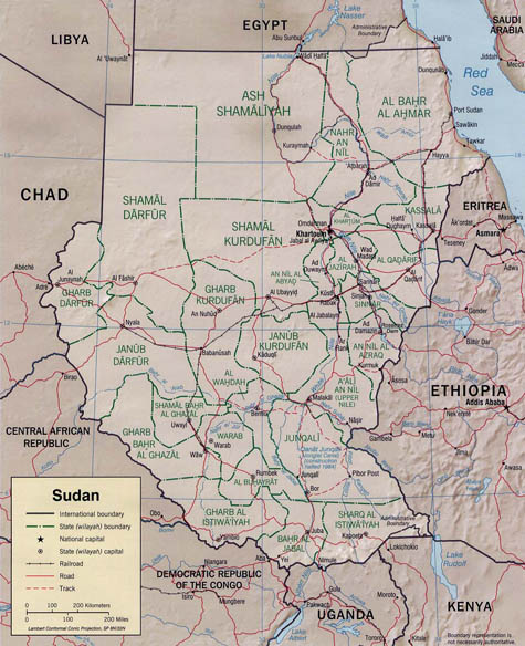 [Image: As Egypt and Sudan gained their independence from Britain, the border between the two countries was determined by drawing a straight line from the sea through Wadi Halfa, a quarantine station on the Nile (which is now an underwater archaeological site due to flooding caused by the construction of the Aswan Dam)].
BLDGBLOG: A great deal of your work examines the political nature of quarantine and the relationship between quarantine and the border. I was particularly struck by the fact that, in some cases, the biological border has preceded the national border, as in the case of the line between Egypt and Sudan.
Bashford: A lot of historians have written about borders, but I think what’s sometimes overlooked is that this temporary line, marked by quarantine practices that maintain a disease on one side of the border and not the other, is often the earliest sign of what later becomes a national, territorial border.
This is also the case with regional borders. The boundary between the nineteenth-century Orient (as the Near East used to be called) and Europe was the place where cholera was controlled. Various quarantine practices were set up every year in and around the Mecca pilgrimage, because there was constant European anxiety that this mass movement—in a place that is just adjacent to Europe—would introduce cholera into Europe itself. So that boundary, which was not an actual territorial border but, rather, an important part of how Europe defined itself in relation to its most adjacent neighbor, the Orient, was made meaningful through very specific, very grounded, practices of inspecting people, putting them in quarantine camps, and monitoring or restricting their movement.
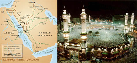 [Images: Routes to Mecca, and pilgrims on the Hajj (second image via Gizmowatch)].
 Edible Geography: You’ve also examined the way these kind of disease borders can define cities as well.
Bashford: Yes—in Imperial Hygiene, I really explored this idea of boundaries at different scales. I structured that whole book spatially. I started with a chapter about smallpox, vaccination, and the border of the body and skin, and I looked at the way that a vaccine introduces disease into the body, in order to create immunity.
Then I moved outwards to the scale of the city. I took Sydney as a place that had certain diseased zones that were quite disordered, and analysed the way in which the establishment of the quarantine station on North Head—in Manly—was an attempt to create clean and dirty spaces within an urban environment.
Then I moved outwards again to think about the entire Australian continent—and outwards again to consider international hygiene and quarantine measures, and the way that the entire globe, due to immigration restriction acts over the twentieth century, became criss-crossed by all kinds of lines of quarantine.
Edible Geography: In that context, I was particularly interested in your paper tracing the origins of the World Health Organization—and public health as a globally regulated phenomenon—back to the International Sanitary Conferences, which were themselves convened to implement quarantine.
Bashford: The question of how to manage infectious disease is foundational for the League of Nations Health Organization, and then the World Health Organization. In fact, even the large philanthropic organizations, like the Rockefeller’s International Health Board, were attempts to prevent infectious disease, both by quarantine and also by hygiene education. In nineteenth-century Europe, the International Sanitary Conventions and Conferences were, in the first instance, about cholera, and the concern about the annual pilgrimage.
What’s intrigued me for many years are the way immigration restriction lines dovetail as quarantine lines. In spatial terms, I’m fascinated by the way this division of pure and polluted spaces can be architectural at a very small and local level, but can also come to structure the globe as a whole.
Edible Geography: Can you give an example of an encounter with one of these quarantine lines today?
Bashford: Airports are places where the demarcations of quarantine lines are very clear, and biological or biomedical terms like “Sterile Zone” still cling to the various clean and polluted zones. “Sterile Zone” doesn’t actually mean sterile zone—it indicates a zone into which only authorized people can go.
Airports still make the link between quarantine and the regulation of movement very clear. Historically, quarantine laws were the main way in which people’s movement over national borders was regulated. Almost all of the immigration acts that proliferated around the globe in the nineteenth century (which we still live with, every time we hand over our passport) were about quarantine regulations. Every immigration restriction act across the world, even now, always has a “loathsome disease” clause in it.
 [Image: An Italian Health Passport, via the Disinfected Mail Study Circle].
Edible Geography: Can you talk a little more about the relationship between health passports, or pratique, and quarantine?
Bashford: What’s interesting is that all of these identity documents—passports, visas, health vaccine certificates, and so forth—only become attached to an individual relatively late in time. Through most of the eighteenth and nineteenth centuries—and into the twentieth century, in some cases—these documents would refer to the vessel on which you arrived into a zone, rather than to you as an individual.
For a ship arriving in Sydney Harbor, for example, there would be a certificate of freedom from disease that pertained to the entire ship, and that would be determined by the route on which the ship had come. If the ship had come to Sydney from London via what was then Ceylon, and if there was known to be an epidemic of cholera or smallpox in Ceylon, then that entire ship would be understood to be diseased and it would be put in quarantine for a certain period of time. I’m very interested in the way that, in the maritime world, the passengers and ship became one body, which could then be categorised as infected or clean, irrespective of the health or otherwise of the individuals on board.
One thing that I’ve always wanted to do more work on is the actual bodily inspection of people to determine whether they’ve got a vaccine scar, from the smallpox vaccine. It’s something that I know was practiced, particularly during an epidemic. Historically, before you had a passport or even a piece of paper that authorized your movement from one zone into another, people were not infrequently checked for a vaccination scar. You could only move from what was understood to be an infected zone into a healthy zone if you had a vaccination scar. It became a kind of bodily passport.
The other fascinating thing about quarantine is that it dreams of being non-porous, but in fact, quarantine lines are always leaky. Quarantine, like today’s passports and visas, is much more about letting some people through and keeping other people out, than enforcing a total border.
BLDGBLOG: I’m also interested in the phenomenon of proto-states testing the limits of their power through bio-political practices—that is, experimenting with how they can control and regulate individual people, and doing so in the arena of medicine. Medical power becomes a kind of stepping stone toward national sovereignty.
Bashford: Certainly, the display of a line around a country—and hence territorial sovereignty—can be put into practice very clearly through quarantine practices. That’s where we started our conversation. Immigration restrictions and quarantine practices go hand-in-hand as the two intertwined practices that determine a border as a border for modern kinds of territory. This takes place at an imaginary level.
But there is a flip side to all of this: the apparent imperative to maintain hygiene and keep out disease sets up the territorial boundaries of a nation, but it also gives that nation an almost humanitarian license to step over its own border and into the territory of another state. Patrick Zylberman and Alexandra Minna Stern wrote about this in my book, Medicine at the Border.
Alexandra Minna Stern, in particular, writing about U.S. quarantine and yellow fever, discussed the way that quarantine at Ellis Island was about inspecting migrants and excluding some people, and thus setting up a sovereignty for the United States. She then went on to show us how the very concern about yellow fever was also a way in which the United States government could offer assistance to, intervene in, and set up hygienic measures in all of the nations adjacent to the south, as a kind of a first way in. Unsurprisingly, this was followed pretty quickly, either by territorial acquisition of those places or by transnational agreements and other extensions of influence. After the Spanish-American War, in a whole lot of places like Cuba, and eventually Panama, Puerto Rico, and even Guam, the first U.S. inroads were around quarantine and infectious disease measures.
So while quarantine and infectious diseases function to set up territorial borders and national sovereignties, for powerful nations and nations with pretty good internal health structures the management of infectious disease in a place over the border is quite a common way to extend sovereignty into that territory.
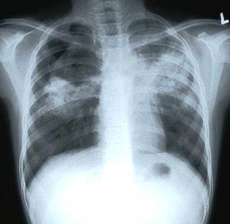 [Image: Tuberculosis seen via x-ray].
Edible Geography: So quarantine contributes to both a spatial out-sourcing or in-sourcing of the border?
Bashford: Exactly. One article that I wrote about quarantine and tuberculosis is called “Where is the border?” It came out of work I was doing with colleagues in the UK about the difference between the Australian history of quarantine and the British tradition.
In Australia, quarantine took place from the physical borders of the nation outwards—the border was pushed way back to the point of origin of any intending migrant. Most people came to Australia from England, and your certificates of health had to be secured before you even got on the ship. This is completely different to the British tradition, because the UK was not, until after World War II, a country of immigration. In fact, the UK had very, very weak, and sometimes completely absent, quarantine laws.
My UK colleagues told me that, today, if you have tuberculosis and you arrive at Heathrow airport, you’re not asked to get back on the plane or to get back on the ship as you would be in Australia. Instead, your name and address are taken and you’re asked to see a doctor in your local area. You’re entirely brought within the borders of the country, and then quarantined or monitored.
These island nations have very different histories of where the border is located. Recent British governments have tried to bring in what they call the Australian model—a system where people get their health checks done at the point of departure. It seems to be much more problematic in the UK than it is for nations that have a long history of rigid quarantine rules.
 [Image: The leper colony at Molokai].
BLDGBLOG: Finally, what examples come to mind in terms of places of quarantine that are particularly striking for spatial reasons?
Bashford: Molokai, Hawaii—that’s one of the original leper colonies dating back to 1865. It’s currently managed by the National Park Service, but there’s a community of people with Hansen’s Disease still living there. It’s a fascinating place. It’s an island within a very remote archipelago, and it’s also on a peninsula. It juts out sensationally underneath the world’s tallest sea cliff. The cliff separated the lepers from everybody else, even on the island, and the island itself was clearly chosen to be separate from the other islands in Hawaii. Natural geographies are being put to use here as a way to create a place of quarantine and isolation.
In addition, nineteenth-century maps of quarantine stations are fascinating for the way that they demarcate zones even within spaces of quarantine. Usually they are divided by race and class—in the nineteenth century, there is typically a specific building within the quarantine station for Chinese passengers, for example. To me, these intricate divisions of space within quarantine stations capture social divisions instantly, and almost too obviously.
This autumn in New York City, Edible Geography and BLDGBLOG have teamed up to lead an 8-week design studio focusing on the spatial implications of quarantine; you can read more about it here. For our studio participants, we have been assembling a coursepack full of original content and interviews—but we decided that we should make this material available to everyone so that even those people who are not in New York City, and not enrolled in the quarantine studio, can follow along, offer commentary, and even be inspired to pursue projects of their own.
For other interviews in our quarantine series, check out Isolation or Quarantine: An Interview with Dr. Georges Benjamin, Extraordinary Engineering Controls: An Interview with Jonathan Richmond, On the Other Side of Arrival: An Interview with David Barnes, and The Last Town on Earth: An Interview with Thomas Mullen.
Many more interviews are forthcoming.


Comments are moderated.
If it's not spam, it will appear here shortly!
This is a fascinating project. It brings to mind an inverse of what one typically associates with the idea of quarantine, raising the issue of small isolated communities designed to protect inhabitants from a presumed hostile environment that surrounds them. I have in mind forward operating bases, defensive fighting positions, remote outposts. The phenomenon of gated communities also comes to mind.
Post a Comment