|
|
 [Image: The basic platform; design your seastead atop this and win $1000]. [Image: The basic platform; design your seastead atop this and win $1000].The Seasteading Institute is sponsoring a design competition to see who can most interestingly visualize a permanent, microsovereign architectural state at sea. "A seastead," they write in the competition brief, "is a floating platform that allows people to permanently settle the ocean as they do land. Professional naval engineers have already designed a bare platform – a structure about 400x400 feet, roughly the size of a city block. What you build on the platform is up to you. It may be a hospital, a casino, a residential community, a cricket stadium, or something entirely different."  [Image: The sample design]. [Image: The sample design].There are some basic engineering constraints that participants will have to heed, as explained both in the call-for-entries and in this forum, and a sample design has been supplied (see images above and below). But I think it'd be absolutely fascinating to annualize this, and launch a kind of eVolo competition for offshore platform design. The skyscraper designs that come out of eVolo might gravitate a bit too strongly toward the biomorphic/diagrid/arbitrary fractal tiling end of contemporary architectural design, but each year's results are always worth checking out. So if architects were asked to rethink the spatial design of offshore libertarian self-rule, and to do so as part of a high-profile annual competition, what sorts of structures might we see? 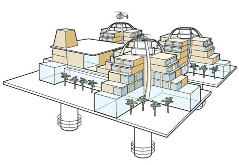 [Image: An illustrated variation of the sample design, from Wired magazine]. [Image: An illustrated variation of the sample design, from Wired magazine].For a little more background, Wired's Chris Baker covered the Seasteading Institute last month. Baker wrote that the Institute "doesn't just want to create huge floating platforms that people can live on," they are "also hoping to create a platform in the sense that Linux is a platform: a base upon which people can build their own innovative forms of governance. The ultimate goal is to create standards and blueprints that can be easily adapted, allowing small communities to rapidly incubate and test new models of self-rule with the same ease that a programmer in his garage can whip up a Facebook app." Here, architectural design would actually help to catalyze new forms of political sovereignty. The cultural possibilities for these offshore spaces are effectively without limit – and they would be self-policed, falling outside the bounds of international law. This opens up a number of legal (not to mention moral) quandaries. Baker reports that Patri Friedman, the Institute's co-founder and executive director, speaking at a Bay Area conference held last fall, "notes that some enterprises – like euthanasia clinics – would incense local authorities, but almost all the ideas attendees [at that conference] come up with would capitalize on activities that skirt existing laws and regulations: Fish farming and aquaculture. Prisons. Med schools. Gold warehouses. Brothels. Cryonics intakes. Gene therapy, cloning, augmentation, and organ sales. Baby farms. Deafeningly loud concerts. Rehab/detox clinics. Zen retreats. Abortion clinics. Ultimate ultimate fighting tournaments." So what might these platforms look like? Submissions are due by May 1.
For his final student project presented last month at Rice University, Viktor Ramos produced The Continuous Enclave: Strategies in Bypass Urbanism.  [Image: From The Continuous Enclave: Strategies in Bypass Urbanism by Viktor Ramos; view larger]. [Image: From The Continuous Enclave: Strategies in Bypass Urbanism by Viktor Ramos; view larger].The project explores how new forms of habitable infrastructure might be extrapolated from a geopolitical agreement – in this case, materializing architectural form from the legal interstices of the Oslo Accords. The result is a fantastic example of architectural speculation: genuinely massive – and impossibly cantilevered – bridges used as transport links, aerial housing, and skyborne agricultural complexes, all in one.    [Image: From The Continuous Enclave: Strategies in Bypass Urbanism by Viktor Ramos]. [Image: From The Continuous Enclave: Strategies in Bypass Urbanism by Viktor Ramos].While clearly defying security protocols, as the "continuous enclave" and its network of bridges cross through sovereign Israeli airspace, these structures would link the dispersed islands of infrastructurally underserved territory now under Palestinian control. From Ramos's own project description: This thesis takes a formal approach to understanding the Israeli-Palestinian conflict by studying mechanisms of control within the West Bank. The occupation of the West Bank has had tremendous effects on the urban fabric of the region because it operates spatially. Through the conflict, new ways of imagining territory have been needed to multiply a single sovereign territory into many. It is only through the overlapping of two separate political geographies that they are able to inhabit the same landscape. One might say that these bridges present us with the staple as geopolitical form. 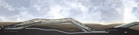 [Image: From The Continuous Enclave: Strategies in Bypass Urbanism by Viktor Ramos; view poster-sized]. [Image: From The Continuous Enclave: Strategies in Bypass Urbanism by Viktor Ramos; view poster-sized]."The Oslo Accords," Ramos continues, "have been integral to this process of division." By defining various control regimes, the Accords have created a fragmented landscape of isolated Palestinian enclaves and Israeli settlements. The intertwined nature of these fragments makes it impossible to divide the two states easily. By connecting the fragments through a series of under- and overpasses, the border between the two states has shifted vertically. In the following cross-section, you can see the internal stacking of the space – an inhabited borderzone that weaves through the lower atmosphere.  [Image: From The Continuous Enclave: Strategies in Bypass Urbanism by Viktor Ramos; view larger]. [Image: From The Continuous Enclave: Strategies in Bypass Urbanism by Viktor Ramos; view larger].To my mind, the project avoids the most obvious and expected pitfall of such an approach – which would be to suggest, naively, that architecture can, in and of itself, lead to a more thorough and lasting peace in the region, as if the entirety of the Israeli-Palestinian conflict would be eradicated if only they had better architecture. Ramos instead uses the Oslo Accords as a kind of spatial source-code from which unanticipated structural forms might be extracted. For those of you who have read Delirious New York, it's as if the Oslo Accords have been turned into a geopolitically active 1916 Zoning Law. That law, of course, established spatial guidelines – for instance, enforcing setbacks for buildings, leading to an era in which skyscrapers rose up like ever-narrowing ziggurats – from which the buildings of Manhattan would then be shaped. As Koolhaas himself writes, in the wake of the Zoning Law architects would "have to carve the final Manhattan archetype from the invisible rock of its zoning envelope in a campaign of specification." In Ramos's project, that "invisible rock" consists of disputed territorial claims hovering virtually over the geography of the West Bank. The distinct new form of spatiality "carved" from that rock is the bypass. 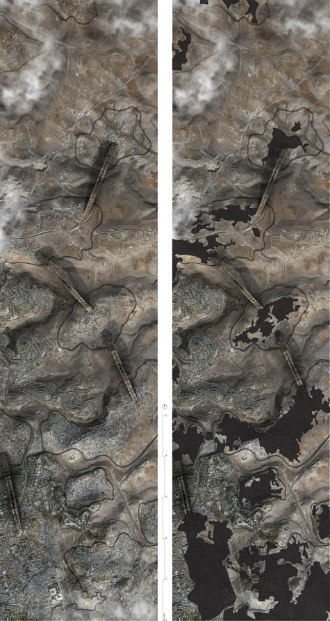 [Image: From The Continuous Enclave: Strategies in Bypass Urbanism by Viktor Ramos; definitely view larger]. [Image: From The Continuous Enclave: Strategies in Bypass Urbanism by Viktor Ramos; definitely view larger].Again, from the project description: One feature of the Oslo Accords is the bypass road which links Israeli settlements to Israel, bypassing Palestinian areas in the process. These are essential to the freedom of movement for the settlers within the Occupied Territories. Extrapolating on the bypass, this thesis explores the ramifications of a continuous infrastructural network linking the fragmented landscape of Palestinian enclaves. In the process, a continuous form of urbanization has been developed to allow for the growth and expansion of the Palestinian state. Ultimately, this thesis questions the potential absurdity of partition strategies within the West Bank and Gaza Strip by attempting to realize them. Thus creating what Ramos calls bypass urbanism, or a self-connected maze of new territories in the sky. 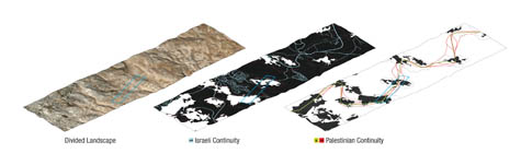 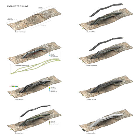 [Image: From The Continuous Enclave: Strategies in Bypass Urbanism by Viktor Ramos; view much larger: top, bottom]. [Image: From The Continuous Enclave: Strategies in Bypass Urbanism by Viktor Ramos; view much larger: top, bottom].There are any number of other directions such a project could go, but I'm particularly excited by the idea of applying this same sort of analysis to other conflict zones, elsewhere, all over the world. Of course, the precedents for this are many. After all, what is the Berlin Wall but a piece of architecture pulled from the dreamscape of international legal infrastructure? In fact, I'm reminded here of Rupert Thomson's under-appreciated recent novel Divided Kingdom – especially because the basic premise of that book was at least partially inspired by Rem Koolhaas's own student thesis project, Exodus, or The Voluntary Prisoners of Architecture. As Koolhaas wrote: Once, a city was divided in two parts. One part became the Good Half, the other part the Bad Half. The inhabitants of the Bad Half began to flock to the good part of the divided city, rapidly swelling into an urban exodus. If this situation had been allowed to continue forever, the population of the Good Half would have doubled, while the Bad Half would have turned into a ghost town. After all attempts to interrupt this undesirable migration had failed, the authorities of the bad part made desperate and savage use of architecture: they built a wall around the good part of the city, making it completely inaccessible to their subjects.
The Wall was a masterpiece. The U.S.–Mexico border would seem an obvious place for any investigation of "bypass urbanism" to begin; just today, the New York Times looked at the decaying after-effects of the Dayton Accords and their spatio-sovereign impact on the future of Bosnia; and Lebbeus Woods has long explored the architectural effects of political separation, from Paris and Berlin to Israel and Sarajevo, seeking out those fissures wherein geopolitics exhibits its own peculiar form of spatial tectonics. But what new kinds of space might we yet extract from territorial agreements between, say, India and Pakistan over Kashmir, or Turkey and Greece over Nicosia – or, for that matter, what strange infrastructures might we build in Baarle-Hertog, what pavilions inspired by the Akwizgran Discrepancy, and how might most interestingly extract architecture from the international date line? 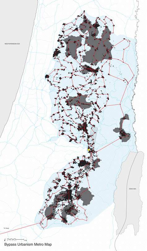 [Image: From The Continuous Enclave: Strategies in Bypass Urbanism by Viktor Ramos]. [Image: From The Continuous Enclave: Strategies in Bypass Urbanism by Viktor Ramos].Even with so many precedents, it would seem, such studies have still barely begun. You can see much, much larger versions of all of these images in this Flickr set: The Continuous Enclave: Strategies in Bypass Urbanism. They are incredibly detailed and well worth exploring in full! (Viktor Ramos's Continuous Enclave was produced at Rice University. It was advised by Troy Schaum under the direction of Fares el-Dahdah and Eva Franch, with additional input from John Casbarian and Albert Pope).
 BLDGBLOG has unexpectedly popped up on a list of The 100 Best Blogs, according to the Times. I'm there alongside some very distinguished company, I have to say, including Owen Hatherley's sit down man, you're a bloody tragedy, and many of the blogosphere's usual suspects, from Boing Boing, TreeHugger, and TechCrunch, to David Byrne, The Sartorialist, and so on. Alex Ross's excellent The Rest Is Noise also made the list (don't miss Ross's book). Of course, there are some very notable absences on the list, not least of which come from the vibrant architecture, cities, and landscape blogging scenes, of which I've always been excited to be a part. The complete roster of 100 blogs is divided up into parts one and two – so check it out if you're looking for new sites to read. And thanks, by the way, for continuing to read BLDGBLOG! It's frightening to say it, but the site's fifth birthday is approaching this summer. (Thanks to Clare Dudman for pointing it out!)
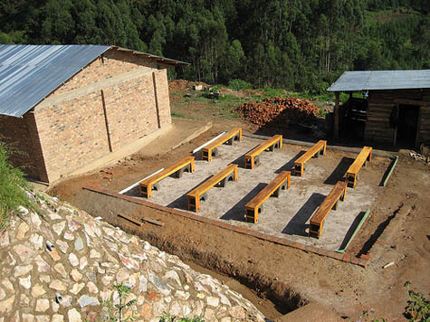 [Image: The finished "math playground" in Uganda, by Project H Design].Project H Design [Image: The finished "math playground" in Uganda, by Project H Design].Project H Design recently completed the installation of a " math playground," or Learning Landscape, at the Kutamba School for orphans of AIDS in rural Uganda. Part outdoor classroom, part spatially immersive lesson in arithmetic, the project gives students a place to study in at least two senses of the phrase. On the one hand, it's simply a forum for learning; on the other, it is literally a place to study: the space itself, if I've understood this correctly, serves as a model for play-based education. 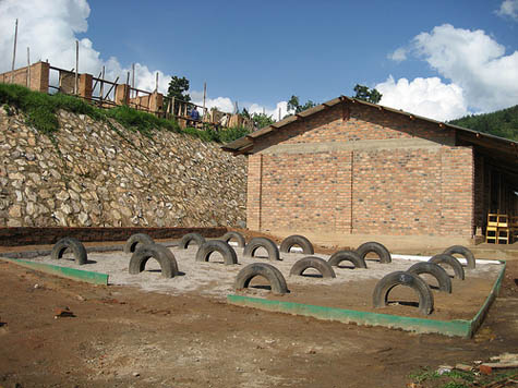  [Images: The "math playground," by Project H Design]. [Images: The "math playground," by Project H Design].That is, within the numbered arrangement of tires and benches is a spatial pedagogy: using the landscape itself, any number of spatialized games, such as "Around The World" and "Match Me," can be used to teach elementary mathematics. 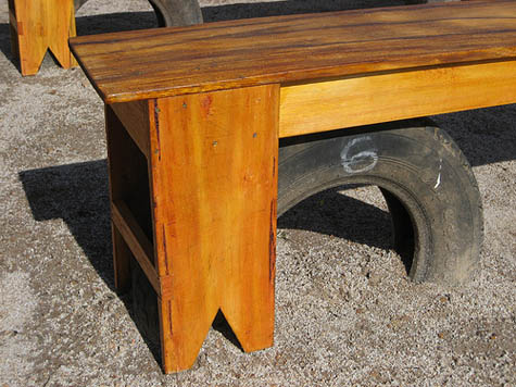 [Images: One the finished benches, via Project H Design]. [Images: One the finished benches, via Project H Design].The didactic landscape was, at one point, simply a kind of mathematical test-landscape in a U.S. gymnasium before being tried out by the students on site in Uganda, before reaching its final installation. 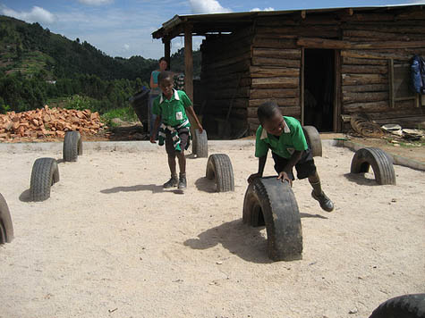  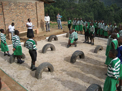 [Images: Testing out the landscape, via Project H Design]. [Images: Testing out the landscape, via Project H Design].Check out the whole research, design, and installation process through their Flickr sets. 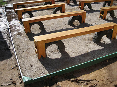 [Images: Via Project H Design]. [Images: Via Project H Design].I absolutely love the idea, though, that it might be possible to derive mathematical lessons from the built environment surrounding us. That, somewhere in the walls, roads, and buildings we find ourselves alive within, are equations waiting to be deduced, geometries to be studied, forces that we can isolate, graph, and understand. Whether through games or lectures, it is the spatial world itself that we study. 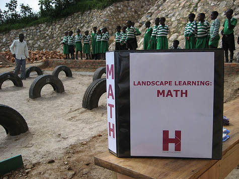 [Images: A handbook to spatial learning, via Project H Design]. [Images: A handbook to spatial learning, via Project H Design].Of course, this is one of the most basic things you do when you first study engineering: you look at a bridge, tower, or other structure and you try to figure out how it stands or works. Or you stand behind Notre-Dame in Paris, staring at those stone cobwebs of intersecting buttressed supports, and you try to understand how it is that cathedrals gravitationally function. But how incredible would it be to realize that, say, your entire city had actually been organized by urban planners two hundred years ago as a kind of inhabitable lesson in mathematics or logical reasoning, like something from the early theories of Friedrich Froebel? Who? In an unbelievably interesting exhibition held two years ago in Pasadena, the Institute For Figuring explored the educational system of a now relatively under-known man named Friedrich Froebel and his influence on what we now call kindergarten. To quote from their online exhibition at length: Most of us today experienced kindergarten as a loose assortment of playful activities – a kind of preparatory ground for school proper. But in its original incarnation kindergarten was a formalized system that drew its inspiration from the science of crystallography. During its early years in the nineteenth century, kindergarten was based around a system of abstract exercises that aimed to instill in young children an understanding of the mathematically generated logic underlying the ebb and flow of creation. This revolutionary system was developed by the German scientist Friedrich Froebel whose vision of childhood education changed the course of our culture laying the grounds for modernist art, architecture and design. Le Corbusier, Frank Lloyd Wright and Buckminster Fuller are all documented attendees of kindergarten. Other “form-givers” of the modern era – including Piet Mondrian, Wassily Kandinsky and Georges Braque – were educated in an environment permeated with Frobelian influence. I don't mean to imply here that Project H's "math playground" in Uganda is an example of Froebelian education – because, as far as I'm aware, it is not – but I do mean to say that it would be amazingly cool if the spatial environments of modern life were organized more along educational lines. 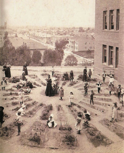 [Images: A Froebelian garden for kids – that is, a kindergarten – brings spatial education to Los Angeles in this archival image, courtesy of the The Institute For Figuring]. [Images: A Froebelian garden for kids – that is, a kindergarten – brings spatial education to Los Angeles in this archival image, courtesy of the The Institute For Figuring].Your every commute to work becomes part of a spatial curriculum, carving out education through space. One of the questions here would be: could you reverse-engineer mathematical lessons from the environment that already surrounds you? Or do you need to purpose-build pedagogic spatiality? In any case, read more about Froebelian education through the fascinating Institute for Figuring, and stop by Project H Design to find out how you can support the philanthropic construction of future Learning Landscapes elsewhere.
An exhibition called In Search of the Miraculous opened up last night at the Camera Club of New York. It runs till March 28th. 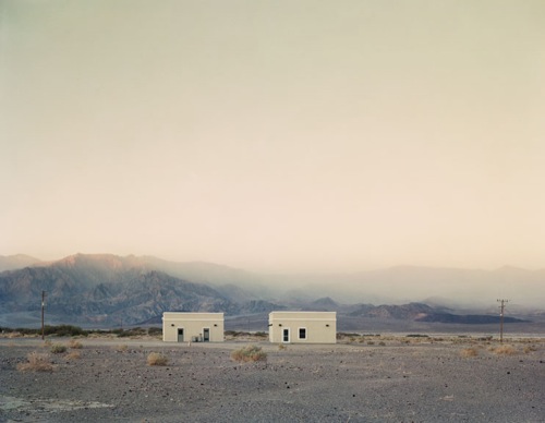 [Image: Two Structures, Death Valley, California, 2007, by Ian Bugaskas, from his series Sweet Water; courtesy of the Jen Bekman Gallery]. [Image: Two Structures, Death Valley, California, 2007, by Ian Bugaskas, from his series Sweet Water; courtesy of the Jen Bekman Gallery].While the above image, by photographer Ian Bugaskas, one of the artists represented in the show, is not actually on display there, Baguskas will instead be exhibiting a series called Sansaram (Mountain People), which visually surveys a very particular landscape microculture in South Korea. According to the Camera Club: Ian Baguskas's portraits made in South Korea of local mountain hikers depict the intersection of recreation and spiritual communion with nature. His project Sansaram from 2005, meaning "people of the mountain," combines landscape views with documentary portraits of native visitors to the Sobaek mountains, encountered on hiking trails. The popularity of this activity can be attributed to the indigenous religion, which is centered on the worship of nature and mountain spirits, and has come to be fused with Buddhism. The series, visible on Baguskas's website (caution: resizes your browser and requires Flash), is a fascinating look at the intersection of geology and anthropology – in other words, how massive landforms can be appropriated by and incorporated into cultural movements and religious traditions. The human experience of the earth's surface here takes on the form of small picnics, ice cream carts parked on paved platforms, lone hikers gazing out over urban developments below, and families standing quietly in the sun. But behind all of that lies bedrock, a huge intrusion of solid, crystalline form that has pushed up from below into detectability and self-exposure. This reminds me, though, that if I could start a university – or, for that matter, simply teach at one – I would love to form a new department, studio, or program called Landscape Anthropology, a specifically and enthusiastically spatialized look at human culture. From the layouts of medieval villages to the floorplans of corporate bank towers, from national parks and monuments to the strange geotechnical rearrangements we force upon rock, digging tunnels, excavating mines, and installing towns and cities, how do human beings experience the earth? This would seem to be one of the largest and most important questions we could possibly ask. In any case, if you're in New York City between now and March 28, consider stopping by the Camera Club for a glimpse of In Search of the Miraculous.
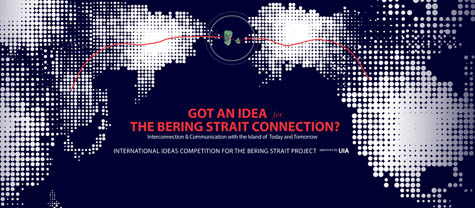 If you could design a bridge across the Bering Strait, connecting the U.S. to Russia, what would it look like? Come up with something good and you could win as much as $80,000 ($20,000, if you're a student). From the competition website: This project is a dream project attempting to connect two continents. In a wide sense, it includes building a tunnel or a bridge at both ends of the strait, extending [the] existing railways of the United States and Russia, and laying a world highway around the coasts of the world, which require a massive amount of construction. Your only two requirements are to design "a peace park with a bridging structure using the two islands, Big Diomede and Little Diomede at the Bering Strait," and a "proposal of how to connect two continents." Of course, Russian engineers have already been considering digging a tunnel between the two continents, and the Discovery Channel has chimed in about how a bridge might actually be built across that "iceberg-swirled ocean near the Arctic Circle." But neither of those plans came with a total of $200,000 in prize money... There's a confusing clock ticking away on the competition website, but you appear to have until March 24, 2009, to register.
 [Image: The "worldwide satellite triangulation camera station network," courtesy of NOAA's Geodesy Collection]. [Image: The "worldwide satellite triangulation camera station network," courtesy of NOAA's Geodesy Collection].I'll be lecturing in New York City at the School of Visual Arts, as part of their fantastic new Design Criticism program, on Tuesday, April 14, in case any of you are in New York that night. I'm on a roster with some really fantastic people, in fact, so definitely check out the rest of the lecture schedule. I'm particularly excited about this talk, at the very least because it's a huge honor to be speaking at the SVA. But I'm also looking forward to discussing post-terrestriality, or the point at which the built environment supersedes the foundation it's based on to become planetary in both scale and implication. From genetically modified crops and artificial wetlands to wholesale plate-tectonic engineering – by way of on-demand weather, constructed reefs, and even ruined buildings mistaken for hills – there is a point at which design infiltrates so thoroughly into the workings of the planet that the Earth's unnaturality, so to speak, becomes impossible to detect. The talk starts at 6pm, is free and open to the public, and will take place at 136 West 21st Street on the 2nd Floor. Here's a map. (You can read more about the Design Criticism course here).
 Benjamin Bratton of The Culture Industry is lecturing tonight at SCI-Arc in Los Angeles, presenting his talk The Program Is Not on the Floor: Stories about Projection, Planning, and Partition. According to SCI-Arc, Bratton's "research, writing, and practical interests include contemporary social theory, the perils and potentials of pervasive computing, architectural theory and provocation, inverse brand theory, software studies, systems design and development, and the spatial rhetorics of exceptional violence." If you go, tell him BLDGBLOG says hello...
 [Image: Courtesy of Morris Architects]. [Image: Courtesy of Morris Architects].Could nearly 4000 oil rigs soon to be decommissioned in the Gulf of Mexico be retrofitted into an American Dubai of offshore luxury hotels? If so, would that really be a good idea? 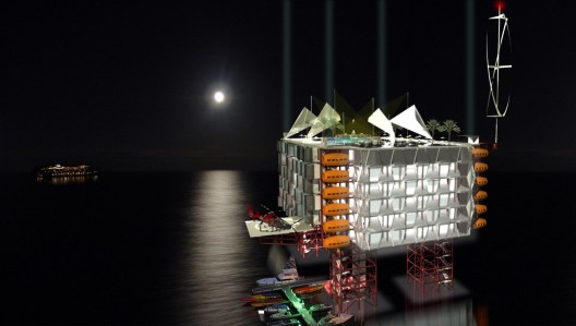 [Image: Courtesy of Morris Architects]. [Image: Courtesy of Morris Architects].Either way, Morris Architects has proposed exactly that: There are approximately 4,000 oil rigs in the Gulf of Mexico varying in size, depth and mobility that will be decommissioned within the next century. If a deck on one of these rigs is about 20,000 square feet, then there is potentially 80 million square feet of programmable space just off the coast of the United States. The current method for rig removal is explosion, which costs millions of dollars and destroys massive amounts of aquatic life. What if these rigs were recommissioned as exclusive resort islands? Could the Gulf be America’s “Dubai” and the rig the artificial island on which to build it? This project examines the possibilities of creating a self-sufficient, eco-friendly high-end resort experience in our own backyard – the Gulf of Mexico. According to Curbed LA, the hotel rooms themselves "are pre-fabricated, designed to be transported out to the rig as a standard cargo container."   [Images: The rooms arrive by ship – before sliding open to form individual cabinettes. Courtesy of Morris Architects]. [Images: The rooms arrive by ship – before sliding open to form individual cabinettes. Courtesy of Morris Architects].Once there, a new world of luxury interiors unfolds above the continental shelf – apparently an ideal environment in which groups of semi-nude women can watch James Bond films.  [Image: Courtesy of Morris Architects]. [Image: Courtesy of Morris Architects].Of course, if the real Dubai is any model for what might actually happen with such a resort, then we'll probably see dozens of oil rigs partially converted to luxury hotels only then to be abandoned by their construction crews and investors. As the lands of southern Louisiana continue to disappear into the Gulf, heavily armed refugees on fishing boats will move out to sea, recolonizing the derelict structures. There will be campfires at night, burning driftwood, and specialty gardens. Within four or five decades of inconsistent contact, the Library of Congress sends out a new, 21st century Alan Lomax to visit those thriving offshore subcultures and record their folk songs and oral histories.  [Image: Courtesy of Morris Architects]. [Image: Courtesy of Morris Architects].He discovers a sort of new Kalevala, written by dwellers of empty structures at sea, somewhere between creation myth and national folk history. The Kalevala of Abandoned Oil Rigs. Alas, it turns out to be a latter day Ossian – that is, he just makes the whole thing up. 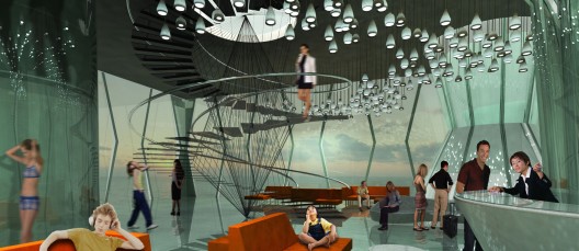 [Image: Courtesy of Morris Architects]. [Image: Courtesy of Morris Architects].Or, of course, the economy will recover, this plan will work, and within a decade you'll be suntanning on a platform in the Gulf of Mexico, reading Self. (Via Curbed LA, with thanks to David Donald).
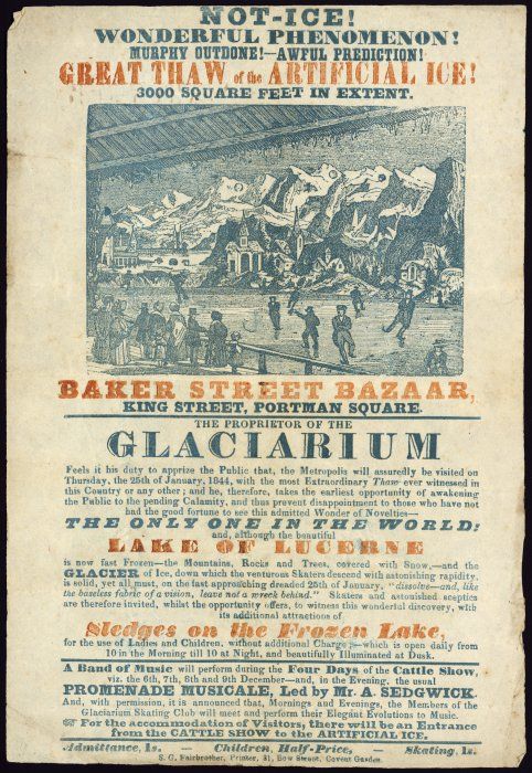 [Image: "Not-ice! Wonderful phenomenon!" A flyer by the Proprietor of the London Glaciarium, 1844, from the National Library of New Zealand]. [Image: "Not-ice! Wonderful phenomenon!" A flyer by the Proprietor of the London Glaciarium, 1844, from the National Library of New Zealand].From the National Library of New Zealand, this flyer announces a " spectacular event," held in London's Covent Garden back in 1844, "in which a model of Lake Lucerne and a glacier of ice were to be thawed. There would be sledges available for women and children," we read, and "members of the Glaciarium Skating Club were to meet and 'perform their Elegant Evolutions.'" Strangely enough, "the event was to be held in conjunction with a four-day cattle show on adjacent premises." Reproducing the terrains of other nations through simulacra of ice in our streets. (Via David Lovely).
 [Image: The geometry of geology, by Vicente Guallart]. [Image: The geometry of geology, by Vicente Guallart].If anyone in London happens to attend this lecture at the Architectural Association – beginning in only about an hour and a half – can you let me know how it is? Vicente Guallart – whose work I've discussed both on BLDGBLOG and in lectures over the past few years – is speaking on Geologics: Geography Information Architecture.
 [Image: The invitation. View larger!] [Image: The invitation. View larger!]The Bjarke Ingels Group – BIG – are kicking off their first solo exhibition with a party next Friday, February 20, in Copenhagen. Check out the invitation, above, for more info. They've got a lot to celebrate, so the mood should hopefully be high. For instance: "Playful," "controversial," "cheeky," "innovative" and "provocative" are just some of the terms used to describe BIG. Headed by Bjarke Ingels, this architectural company has in the space of a few years created prize-winning projects, a long list of innovative buildings and an international reputation, as well as taking an active part in current debates in society. Starting out from a vision aiming to free architecture from tired clichés, choosing instead to see modern life as an inspiring challenge, BIG has made a major contribution to the renewal of the Danish architectural tradition. The exhibition itself opens on the 21st. (Somebody fly me over, please!)
 [Image: A moldy sofa, otherwise unrelated to this post, photographed by Flickr user melinnis – who also made this awesome image]. [Image: A moldy sofa, otherwise unrelated to this post, photographed by Flickr user melinnis – who also made this awesome image].Russian scientists have begun testing blood stains on the sofa where novelist Alexander Pushkin is rumored to have died, in order to determine if those stains might have come from Pushkin himself. At least two things interest me here: 1) It's the forensic sciences applied to antique furniture in order to find the otherwise undetectable remains of a dead Russian novelist. One might even say residue here, not remains at all; it is the barest of traces. Suddenly, though, it's as if those old stuffed sofas, fading carpets, and tables of hand-worn wood in obsolete interiors around the world have been transformed into a kind of archaeological site, in which the chemical traces of literary history might yet be discovered. The sofa is Pushkin's Calvary, if you will – a chemical reliquary. Furniture becomes a kind of hematological Stargate into literature's mortal past. Who else might they find in there? You go around the world performing genetic tests on antique furniture to see which novelists ever used it – traces of Sebald, Hemingway, Tolstoy. 2) Two words: Pushkin Park. We clone Pushkin and start a theme park. Like a thousand Mini-Me's well-versed in storycraft, Pushkin – one man distributed through a thousand bodies – wanders the artificial landscape, and like some strange Greek myth wed with Antiques Roadshow, he tells the crowds, "I sprung forth, fully formed, from a sofa..." And there begins a tale for stunned tourists. (Via the Guardian).
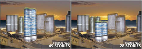 [Image: The revised tower, via the Las Vegas Sun]. [Image: The revised tower, via the Las Vegas Sun].A new boutique hotel in Las Vegas designed by architect Norman Foster – who is soon to lose his seat in the House of Lords after becoming a Swiss citizen to avoid paying taxes – is being cut almost in half due to a construction error: " 15 floors of wrongly installed rebar." The hotel, called the Harmon, was meant to stand at 49 stories; it will now reach a mere 28. "It’s still unclear how the Harmon will be capped," the Las Vegas Sun reports, "and what reengineering will be required for such infrastructure elements as elevators and vents. If the Harmon’s exterior isn’t significantly redesigned, it risks looking unmistakably out of proportion. Think 28 oz. of tomatoes squished into a 16 oz. can." Midway through becoming what you were meant to be, an unanticipated internal flaw forces you to become something else entirely – for good or for bad, that remains to be seen. (Via Archinect).
A Welsh farmer has become an " agricultural saboteur" by "secretly planting and harvesting genetically modified varieties of maize and feeding them to local sheep and cattle." This undercuts Wales's ability to claim that it is a GM-free nation. An unrepentant Harrington [the farmer in question] said he had resorted to the secret planting after the Welsh assembly, which voted unanimously for GM-free status in 2000, refused to have any meaningful discussions over its policy. He said: "Out of frustration I went and bought some varieties of maize bred to be resistant to a pest called the European corn borer and which are grown widely in Spain, France, Germany and the Czech Republic."
The varieties he chose were on the EU common variety list, and as such it is legal to grow them anywhere in Europe. The ease with which this sort of thing could happen makes it obvious that the genetic purity of a nation's agricultural supply cannot be rigorously policed. 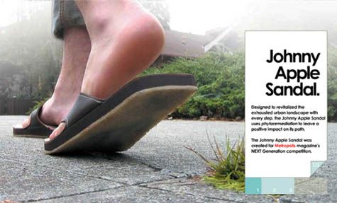 [Image: "Johnny Apple Sandal" by Lift]. [Image: "Johnny Apple Sandal" by Lift].Briefly, I'm reminded of a design project from nearly half a decade ago called " Johnny Apple Sandal," where the soles of a pair of sandals had different varieties of wildflower seeds embedded in their plastic; as your soles wore down, the seeds were released – theoretically going on to form new landscapes. A kind of pedestrian agronomy. But what a perfect tool for agricultural smuggling! You load up your sandals with genetically modified seeds, fly to Wales, and go for a long hikes in the Brecon Beacons. Soon enough, you've contaminated the hills with illegal plants, or forms of life subject to government regulation. In any case, I also can't imagine that this is the only example of such a thing; this farmer just seems like the only one who was caught. It's not hard to speculate that there are what might be called – with no small amount of irony – protest gardens full of genetically modified plants sprouting in secret across the world. What strange cultivations might we yet stumble upon in some unofficial garden in the woods? (Thanks, Alex, for the Welsh farmer article!)
 [Image: By David Gray for Reuters, via The New York Times]. [Image: By David Gray for Reuters, via The New York Times].
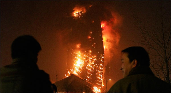
Amongst many, many signs that the building boom has come to an end, from gridlocks of cars abandoned at the Dubai airport by fleeing workers to massive holes in the urban surface of Chicago, to entire architectural firms going out of business, to delayed towers and theme parks on pause, none seem quite as explicitly apocalyptic as the sight of OMA's CCTV complex – that is, the part of it known as TVCC, containing a luxury hotel – roaring with flames.
 [Image: By Andy Wong for the Associated Press, via The New York Times]. [Image: By Andy Wong for the Associated Press, via The New York Times].
The boom ended long ago, but its icon are now on fire.
(Note some updates on this story in the comments thread, below).
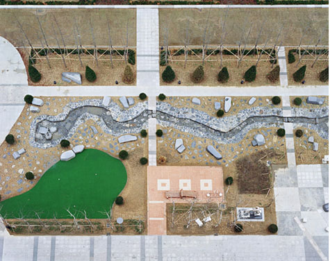 [Image: "Daechi Dong," a photo by Hosang Park, from his series A Square].Note: This is a guest post by Nicola Twilley. [Image: "Daechi Dong," a photo by Hosang Park, from his series A Square].Note: This is a guest post by Nicola Twilley.Korean photographer Hosang Park's series A Square consists of bird's-eye views of the small, over-landscaped parks that seem to accompany modern apartment towers all over the world. As Park explains, these "parks" are too small to serve their ostensible purpose: as open space for recreation and places "to make discussions or take a rest." In the UK and US, they are included in new construction projects to fulfill the letter of planning regulations (if not the spirit) – a token band-aid of "nature" applied to high-density development. As Park points out, their presence in Korea is both a reassurance and an investment: the trees, paths, and water features, no matter how artificial, push up property prices by providing an implicit guarantee of "the environmental benefits of a place where they belong."  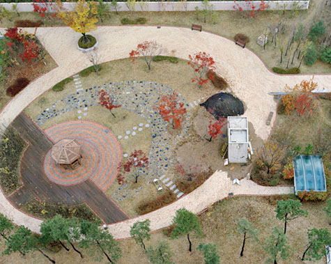 [Images: "Howon Dong" and "Sinbong Dong 2," photos by Hosang Park, from his series A Square]. [Images: "Howon Dong" and "Sinbong Dong 2," photos by Hosang Park, from his series A Square].Park's parks are photographed from above – which seems, in fact, to be the view for which they were designed. As two-dimensional compositions of curved paths, colored paving, and rhythmically spaced rocks or trees, they resemble pleasing, if sterile, designs for wrapping paper or Ikea rugs. Tellingly, they are also completely empty. Park explains that he took these photos while he was living on the 13th floor of Jugong Apartment in Chang-dong, Seoul. He and his hundreds of neighbors experienced their park as a a patch of eye candy – visual respite from the concrete and tarmac of their surroundings. Its cornucopia of amenities – climbing frames, fountains, seesaws and swing sets, pagodas, grass, ornamental rocks, meandering paths, trees and flower beds, benches, ponds, basketball courts... even public art – are crammed together as visual shorthand for endless leisure. They are landscape as signage, a placeholder for the possibilities of a park. 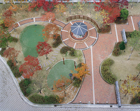 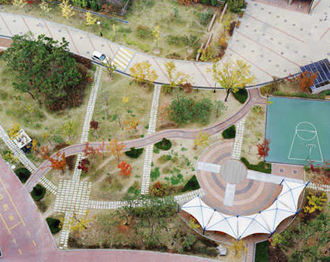 [Images: "Samsung Dong" and "Uman Dong," photos by Hosang Park, from his series A Square]. [Images: "Samsung Dong" and "Uman Dong," photos by Hosang Park, from his series A Square].But could we then imagine that Korea's urban landscape subcontractors have been applying the lessons of graphic design to their creations, as if to a poster or magazine spread? The spaces between ornamental planters are carefully kerned, the edges of flower beds masterfully shaped through ragging to create an "organic" appearance – each element ordered and constrained by a Tschicholdian grid. Or perhaps these parks are the work of one visionary landscape designer, a passionate disciple of Edward Tufte. His goal is the ultimate park infographic, and he diligently recombines ponds, benches, and pagodas to achieve ever greater data density that allow for ever more sophisticated landscape analyses. The published results will become the canonical park design text for a generation, changing public policy as effectively as John Snow's landmark cholera outbreak map of London once did. 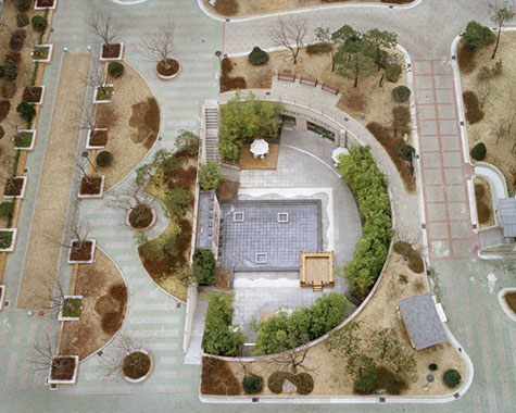 [Image: "Sindorim Dong" by Hosang Park, from his series A Square]. [Image: "Sindorim Dong" by Hosang Park, from his series A Square].Finally, I'm reminded of the Royal Horticultural Society's model gardens at Wisley. Wisley, an otherwise unremarkable village in Surrey, is home to an educational garden, meant to fulfill the Society's remit "to show to the public the best kinds of plants to grow." Behind the scenes at Wisley, fields are devoted to trialling difficult, delicate, or entirely new kinds of flowers, vegetables, and fruit for "garden or ornamental use." Teams of horticulturists partner with botanists, entomologists, and pathologists to determine the correct details, cultivation, and advice for each group of plants, with high performing plants winning an Award of Garden Merit (AGM) – the gardening equivalent of a Good Housekeeping Seal.  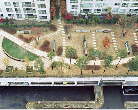 [Images: "Jangan Dong" and "Sinbong Dong," photos by Hosang Park, from his series A Square]. [Images: "Jangan Dong" and "Sinbong Dong," photos by Hosang Park, from his series A Square].AGM-winning plants are then arranged in model gardens at Wisley, to which the public is invited to learn the ideal varietals, patterns, and conditions for a garden on chalky soil, say, or a poorly drained lot. These model gardens are not actually intended to be the private back yards they resemble; instead they are part-instruction manual, part-shop window, part prototype of future, unrealized landscapes elsewhere. Like Park's parks, they are primarily designed to be read, rather than sensed or experienced; and they are deliberately exhaustive in their approach, with each rather small plot landscaped to show all appropriate elements of, for instance, a sub-alpine rock garden. Which leads me to wonder if Park's photos have inadvertently documented an experimental array of urban test gardens, new spatial formats for high-density leisure in their beta phase. (Hosang Park's work discovered via Flavorwire. Earlier posts by Nicola Twilley include Dark Sky Park and Zones of Exclusion).
|
|


