
Lost Roads of Monticello
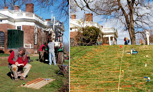 [Images: (left) An archaeologist examines soil cores. (right) Researchers plot lost roads across the grounds of Monticello. Courtesy of the Glenn A. Black Laboratory of Archaeology at IU Bloomington].
It's hard to resist a caption referring to a "team of researchers" who have used their "electrical resistivity profiler to discover long-buried roads around the historic Virginia home" of 18th century U.S. president Thomas Jefferson. But that's exactly what you'll see courtesy of a recent press release from Indiana University.
Specifically, we read, a team of Indiana University archaeologists have "conducted a landscape study to find evidence of two lost roads: a 'kitchen road' that serviced the Monticello kitchen, and a formal carriageway that circled along the Ellipse Fence marking the edge of the East Lawn and the formal landscape in front of Monticello."
A combination of soil cores and direct electrical data helped that team outline this otherwise lost geography at the heart of U.S. presidential history and across the original lawns of American Palladianism. Jefferson, as you might know, was an architect, one heavily influenced by the texts and buildings of Andrea Palladio. American architecture, from day one, was, in a sense, a facsimile: created, with far-reaching variations and personal stylistic quirks, based on reproduced manuscripts from Europe.
In any case, stepping back: beneath Jefferson's lawn are lost roads.
I'm reminded here of an amazing story published two years ago in the New York Times about "ancient roads," dating from colonial times, in the U.S. state of Vermont.
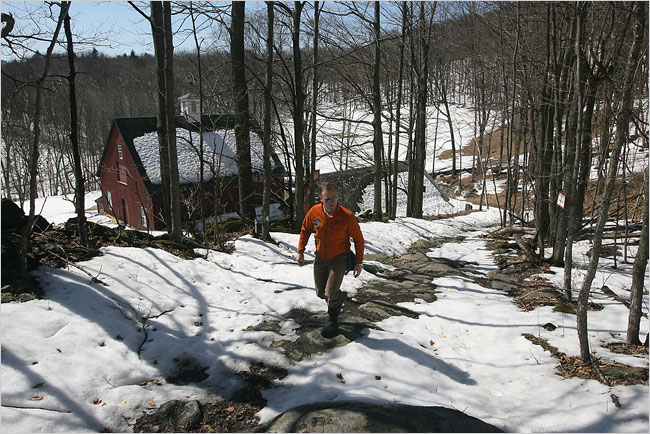 [Image: Walking an "ancient road" in Vermont; photo by Joseph Sywenkyj for The New York Times].
As the The New York Times explained back then, a 2006 state law gave Vermont residents a strong incentive to uncover the buried throughways in, around, and through their often quite rural towns. Indeed, "citizen volunteers are poring over record books with a common, increasingly urgent purpose: finding evidence of every road ever legally created in their towns, including many that are now impassable and all but unobservable."
These "elusive roads"—many of them "now all but unrecognizable as byways"—are lost routes, connecting equally erased destinations. In almost all particular cases, they have barely even left a trace on the ground; their presence is almost entirely textual.
They are not just lost roads; they are road that have been deterrestrialized.
If these ancient routes can be re-discovered, however, then Vermont state law dictates that they can also be added to official town lands (and thus be eligible for some kind of federal something-or-other). Accordingly:
- Some towns, content to abandon the overgrown roads that crisscross their valleys and hills, are forgoing the project. But many more have recruited teams to comb through old documents, make lists of whatever roads they find evidence of, plot them on maps and set out to locate them.
Like something out of the poetry of Paul Metcalf, or even William Carlos Williams, the descriptions found in these old documents are narrative, impressionistic, and vague. They "might be, 'Starting at Abel Turner’s front door and going to so-and-so’s sawmill,' said Aaron Worthley, a member of the ancient roads committee in Huntington, southeast of Burlington. 'But the house might have burned down 100 years ago. And even if not, is the front door still where it was in 1815? These are the kinds of questions we’re dealing with.'"
 [Image: A hand-written inventory of Vermont's ancient routes; photo by Joseph Sywenkyj for The New York Times].
While making sense of cryptic references to lost byways is fascinating in and of itself, these acts of perambulatory interpretation are part of a much larger, fairly mundane attempt to end "fights between towns and landowners whose property abuts or even intersects ancient roads."
- In the most infamous legal battle, the town of Chittenden blocked a couple from adding on to their house, saying the addition would encroach on an ancient road laid out in 1793. Town officials forced a showdown when they arrived on the property with chain saws one day in 2004, intending to cut down trees and bushes on the road until the police intervened.
Think of it as landscape hermeneutics: hunting down traces of a disappeared landscape.
What would happen, then, if you discovered that an ancient road actually passes through your house? Your living room is a former throughway, and old paths knot and twirl off to every side; one even leads right through the guest bedroom. And then another road pops up, and another—and you realize that you live on the intersecting scars of a lost built environment, some old village that disappeared or was destroyed in an H.P. Lovecraft-like enigmatic disaster.
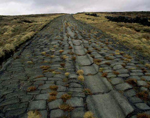 [Image: An old Roman road in Britain; photo via Historic UK].
I'd also be curious, meanwhile, to see what might happen if such a law was passed in a city like London. In an old but interesting review of the book London: City of Disappearances, edited by Iain Sinclair, we're told that London "is a city of the forgotten." It is where anyone "can still disappear without trace." Indeed, London is a city "built upon lost things"; it "towers above forgotten underground rivers and discarded tunnels. It is built upon old graveyards and burial pits."
Best of all, entire London streets have disappeared: "Catherine Street, Jewin Street, Golden Place are just three of the vanished thoroughfares named in a litany of sorrowful mysteries," our reviewer points out. "Other streets have been curtailed. Swallow Street has been swallowed by burgeoning London. Grub Street has been renamed Milton Street."
So what would happen if someone—who liked "getting out and looking for hints of ancient roads"—were to set about such a task elsewhere, in a city made from unstable geographies flashing in and out of county land registers?
I'm reminded here of China Miéville's short story "Reports of Certain Events in London," in which "unstable" streets appear and disappear throughout the city. One night they're there, the next night they're not.
Or take Chris Carlsson's explorations of San Francisco's ghost streets. "Intrepid explorers of San Francisco regularly stumble upon the many ghost streets that still hide all over town, rewarding the patient pedestrian for their diligence," Carlsson wrote last autumn. "Mostly they are on hillsides where steep grades impeded road building at earlier moments in history, but they're still presented as if they were through-streets on the maps."
 [Image: A map of San Francisco, including many "ghost streets," courtesy of Streetsblog SF].
Carlsson's post—something every San Franciscan should read—seemingly paved the way for a later exploration of "San Francisco's unaccepted streets," throughways too ephemeral for any real act of archaeology.
This unaccepted geographical unconscious of the city was recently mapped by Nicholas de Monchaux in an awesomely ambitious project called Local Code. It's hard to exaggerate how interesting this project is; the following embedded video barely does it justice:
Here we are, then, surrounded by lost roads, forgotten throughways, and unaccepted streets. We turn on ground-penetrating radar and we find lost highways. What new cartographies could possibly account for these layers? With avenues leading nowhere and medieval freeways whose stratigraphic routes remain unpaved?
Finally—though by no means answering these questions—roughly two years ago, historian Kitty Hauser published a book called Bloody Old Britain. That book told the story of pilot, and accidental archaeologist, O.G.S. Crawford. Crawford pioneered the use of aerial photography in both discovering and analyzing ancient sites. Learning to read the landscape from the air, on the look-out for German ditches and bunkers, Crawford "would later apply this kind of skill honed in war, the trained interpretation of visual evidence, to the peacetime work of archaeology," Hauser writes.
In the process, he realized almost instantly that you could detect, from high above, the traces of ancient landscape features that would otherwise have gone unseen. For instance, "at certain times of day, when the sun is low in the sky, the outlines of ancient fields become visible over Salisbury Plain, as shadows throw their ridges and dimples into sharp relief; these are known as ‘shadow sites.’” Much of this comes down to the specific species of plant growing over these landscapes:
- Field archaeologists know that vegetation grows differently on soil that has been disturbed, even if that disturbance happened centuries ago. They know that crops grow more luxuriantly over silted-up ditches, and more stunted where there are buried remains. The site of a Roman villa might go unnoticed until a field of wheat grows and ripens, to reveal most strangely the outlines of buried masonry, only to disappear again at harvest. Slight contours or indentations on the land marking out the site of a lost settlement might be invisible to the eye until a low sun throws them into sharp but momentary relief.
- Barley is a more sensitive ‘developer,’ for example, than oats, wheat, or grass, but only in certain soils. Dry spells can bring about remarkably sharp crop sites, like the outline of the medieval tithe barn, complete with buttresses, that appeared in the grass at Dorchester in June of 1938.
- One of the most remarkable things about aerial archaeology is that very few human processes will completely remove a site from view for ever. It might be decades—centuries even—before the right combination of crop growth, rain, sun, and aerial observer results in a site manifesting itself and being photographed. But unless deep excavations or quarrying are carried out, removing all traces of the site, the possibility remains that one day, under new conditions, it will reveal itself.
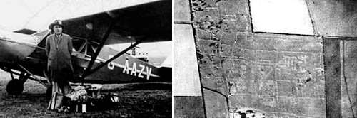 [Image: O.G.S. Crawford and his archaeological airplane; via Kitty Hauser's Bloody Old Britain].
What, then, if we could combine all this? Dead streets buried beneath the sprawling lawn of a U.S. president—himself now erased from the historical memory of U.S. Conservatives—crossed with lost streets from San Francisco, wed with linear archaeological sites known only from the air of 1910s England, meeting ancient roads through the hills of rural Vermont, informing short story sci-fi by China Miéville: how does our understanding of the built environment accordingly change?
What ancient routes exist all around us—like the dead streets of California City?
 [Image: California City, CA; view much larger!].
When I first mentioned the story of Vermont's ancient roads two years ago on BLDGBLOG, commenters pointed out things like the Icknield Way, a.k.a. the "oldest road in Britain," as well as lost railway lines in North Dakota:
- I've done a lot of 'landscape hermeneutics' with former rail lines. I'm working on photographing every town in North Dakota, and most of these towns were built on a rail line. Many of those lines are now long-gone, so there's often a ridge running through the town where the railroad used to be. Some of the tiniest spots (like Petrel) that still manage to get on the map can only be identified by a swath of cleared land where a railroad siding and depot might have been.
- For the last two years I've been on a National Trust committee working on heritage listing for Coxs Road, the first road across the Blue Mountains west of Sydney that opened up Australia to European settlement. Its bicentenary is in 2015.
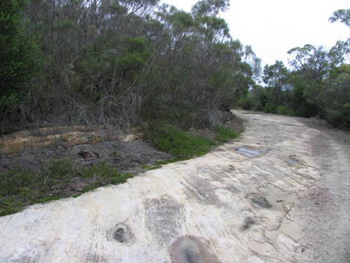

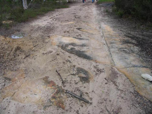 [Image: Three views of Australia's lost Coxs Road, taken in the Woodford area].
- Numerous pieces of it survive intact, and it does, indeed, sometimes disappear under houses. I've also been working on an overlay of it for Google Earth and even some virtual sections done using SketchUp... Its entire construction is detailed in the diaries and reports of its builders so that it can still be tracked through farmland where there is no visible trace of it.
It also relates to Australian indigenous mapping via ancestor stories and songlines, to produce virtual highways that can easily be followed but have very little obvious physical evidence of their existence.
(Monticello story spotted via Jessica Saraceni's great newsfeed over at Archaeology Magazine. Of interest, meanwhile, earlier on BLDGBLOG: Ancient Roads, from which part of this post actually comes, Ancient Lights, and Z).


Comments are moderated.
If it's not spam, it will appear here shortly!
Fantastic post, Geoff! Can I correct one teensy spelling mistake? You have given 'Icknield' as 'Ickfield' (as hovering over the link makes clear). I am fortunate enough to live in a village (Pitstone) which is actually on the Icknield Way - or in the case of the older part of the village, between it, as there are two Icknield Ways hereabouts, the Upper and Lower, for use in different seasons.
5th Studio's award winning masterplan for the Lea Valley involves the development of a lovely big old road for walks from the countryside to the Thames in East London named "Fat walk". Their proposal harmonizes and connects derelict or "remnant parcels" of industrial and disused public land into a landscape park spreading down this large urban area, the Lea Valley.
I had to re-format a comment from bpnotv:
"You've probably posted this one before, but there's also the palimpsest of the old Electric Railway that runs through [West?] Hollywood, which I discovered once while looking... at an aerial map.
---------
Thanks for the spelling correction, by the way, drumbux; I've now corrected it. And, Geraldine, I will look into 5th Studio's project!
Continually amazed by the breadth of your knowledge. Great post.
ever heard of the old straight track?
Alfred Watkins wrote a book about the ancient straight tracks in the british landscape that predated the romans. IN the new view of atlantif, john mitchell wrote about these tracks that apear to be everywhere on the globe, not just britain.
check it out.
Interesting stuff!
Two things come to mind:
While visiting friends last summer in central Massachusetts, we stayed in a house that was over 150 years old. In the adjacent woods were the wrecks of automobiles from the 1920s; apparently there used to be a road between adjacent villages there. http://www.pbase.com/edhahn/image/112867298
Second, part of the American Airlines Flight Academy were built over the top of the old Greater Southwest Airport, which was made obsolete when DFW Airport opened. Parts of the runways were made into roads (Amon Carter Blvd, to be specific.)
http://bit.ly/cVPaDW
This reminds me of an archaeological survey that I did in Belize about 15 years ago. My partner and I were hacking a transect through the forest and had spent several days of difficult slogging up and down hills. One day on the way back from the end of the transect we stopped to take a drink. While we were stopped I looked around and realized that we were standing in the middle of an old logging road. It had almost completely disappear and was only noticeable because the plants on it were only about 10 feet high. It saved us quite a bit on our walk to the end of the transect though.
Often the layers history of a place are recalled in the names of the streets--here in RI, Narragansett Indian names are found side by side with the names of the prominent colonial families, with the newest ones seemingly named after some real estate developer's wife or daughter. The very oldest English roads in southern RI are as unwavering as their ancient Roman counterparts--before the land was sold off, the first roads were surveyed in straight lines for sometimes miles at a time, quite unlike most other back roads that weave by colonial metes and bounds.
The overlay of transportation routes on a landscape rearrange the central places--driftways and Indian trails change to turnpikes then railroad crossings then highways and interstates. Here is a link to great example--the old New London Turnpike, which once connected Providence RI with New London CT.
Zoom in on Google Maps, then pull the image down, until the turnpike crosses Division Road by RT 95. North, the pike travels through the most densely populated parts of the state. But at Division Road the turnpike is closed to the public--moving south if you are zoomed in close enough it changes back and forth from several times from paved to dirt and back to paved, and from open to closed. Following the road southwest, names of mills, patriarchs, and widows long gone cross the old pike--entire communities that once existed along its length, like the one at Hell's Half Acre, virtually impossible to find today-- -- others one can surmise once took people to the destinations the road is named after but which today are long gone too.
Not far to the west is Nooseneck Hill Road (Rt 3), which usurped the turnpike's traffic once it was paved in the early 20th century, Rt 3 itself and the businesses it sustained were in turn usurped by interstate 95 when that came in the 1960s. Gas station home businesses, all closed now, other places are overgrown fields, double-door carriage barns and blacksmith shops mostly fallen in. The old laneways are still there, crossing the turnpike and Rt. 3, with most dead-ended at Rt. 95, though some were given a bridge or were bridged. For locals when the highway came through, the closure of these old roads completely disrupted the way to get from A to B, and changed the importance of numerous central places, testified by the closed gas stations and empty foundations and grass filled parking lots. Follow the track of Rt 95 through southern RI and you can find dozen of these the fossil thoroughfares that stop at the interstate and clearly still exist under its roadbed now. Travelers today zip along the modern highway never knowing they are crossing dozens of these old roads--though sometimes there is a lonely guardrail in the middle of nowhere, inserted to block some local farmer back in the '50s from accessing the highway from his now defunct laneway.
Back to the map, the old turnpike has almost disappeared entirely before it meets up with the interstate, (zoom out and the name even disappears, though the track in the landscape is still visible) From the map it appears that just before the intersection of the pike and Rt 95, the interstate has actually paved over and adopted the track of Rt 3, whose fairly straight track now deviates to take it to a bridge crossing under the interstate.
Shortly south of there the track of the New London pike returns on the other side of the interstate too, paved now and renamed as Nooseneck Hill Road, traveling along to the border with Connecticut where it once again becomes the New London turnpike. The efficiency of the route though southern RI is reflected in the course of both Rt 3 and the interstate, both of which track parallel to the now largely dead pike.
Great posting. It reminded me of this NOVA episode from 2002: http://www.pbs.org/wgbh/nova/zeugma/tools.html
The story is about an ancient site in Turkey, soon to be covered by the resevoir of a new dam. The primary archeological value obtained from this were some amazing mosaics.
What was mainly interesting to me were the remote techniques that are described on one of the links. These allowed them to quickly pinpoint likley locations and begin digging.
There are also links to other ancient sites soon to be located under dam resevoirs. These sites are being described as "doomed by dams." I don't know what being coverd by tons of water does to these ruins. However I imagine in some cases it preserves the wonder at discovery for some future generations.
Definitely loving the data visualization of Local Code - but how on earth with all the smart thought they put into did they get away with that trite elevator muzzack sound-design?
We need to open up a dialogue with the design community about audio. Everyone's made the transition beautifully to a hyper visual universe of project presentation but I'm consistently disappointed by the audio side of things.
Post a Comment