
Michigan Deep Woods Triangle
 [Images: The forests of northern Michigan, via Google Maps].
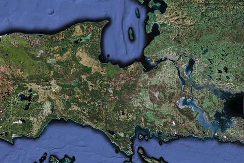
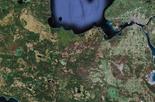
In the woods of northern Michigan, near Hiawatha National Forest, is a massive triangle, unnamed and unlabeled on Google Maps.


 [Images: Geometry amidst the forest, via Google Maps].
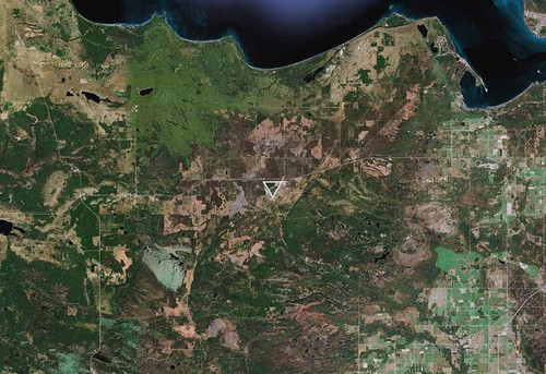
But, despite its anonymity (it even disappears from view altogether when you switch from "Satellite" to "Map"), this is not some underground HQ for a secretive cult of aerially-minded geoglyph-builders, and it's not more scientological circles—it's a former military base and landing-strip complex called Raco Army Airfield.
As it is, the site's monumental geometry, with its northernmost airstrip aligned almost perfectly east-to-west, makes a massive and slightly puzzling triangle in the middle of heavy forest.
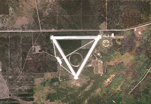
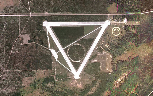
 [Image: Raco Army Airfield, via Google Maps].
Raco AAF is a facility that has seen a variety of different uses, according to the website Abandoned & Little-Known Airfields: "The site of the pre-WW2 civilian Raco Landing Field was evidently reused by the military at some point after 1940 for the construction of a much more elaborate military airfield, intended to provide protection to the Sault Sainte Marie locks." However, "As no threats materialized to the locks, the airfield was apparently little-used, or possibly never used at all." Anti-aircraft guns were nonetheless installed on concrete pads in the surrounding forest; these pads remain in the woods today, overgrown with moss and tree roots, offering an unexpected and highly artificial surrogate bedrock for the ecosystem around them.
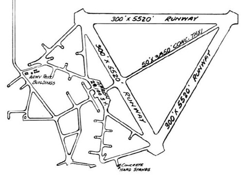 [Image: A plan of the site, via Abandoned & Little-Known Airfields].
The facility was later armed with nuclear missiles:
- Part of the airfield property was later reused by the Air Force to build a launch site for the huge BOMARC ramjet surface-to-air missiles. The BOMARC was a long-range surface to air missile, intended to shoot down Soviet bombers with a nuclear warhead.
This facility was known as the Kincheloe AFB BOMARC site, and it was manned by the 37th Air Defense Missile Squadron starting in 1960. The BOMARC site was a rectangular installation, just southeast of the runways. It operated the 2nd-generation IM-99B version of the BOMARC missile. The site consisted of a grid of 28 individual missile launcher buildings on the south end, along with larger missile assembly buildings on the north end.
Abandoned & Little-Known Airfields goes on to quote a man named David McLaren: "I visited Raco AAF back in 1974 after spotting it from a B-52 at 20,000 feet. At that time the seedlings had just been planted. The only remaining Air Force structure was a mess hall, which still had the stainless steel coolers & tables. The missile buildings were intact, and although the launching equipment had been removed, the buildings still had their heaters installed."
Some time later, after the field was closed, a "circular automobile testing track" was added to the center of the site, and this was later replaced by a "serpentine vehicle testing track," which you can see in the lower right—the southeast corner—of the above images.
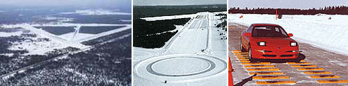 [Images: The Smithers Winter Test Center].
And so the site remains today, oddly: it is intensively reused every winter by a small army of vehicle-testing engineers, who have transformed the facility into the Smithers Winter Test Center. This former military airport, visible as a near-perfectly white triangle hidden amidst the sub-arctic trees, is "ideal for testing and conducting performance evaluations of vehicles, tires and components under the special challenges of extreme cold and hazardous road conditions."
I stumbled across this deep woods triangle—which surely deserves its own Center for Land Use Interpretation listing—while doing otherwise unrelated research with Anya Domlesky, here at the Canadian Centre for Architecture. For more information (and more images), see Abandoned & Little-Known Airfields—but don't miss this much larger aerial shot of the site.


Comments are moderated.
If it's not spam, it will appear here shortly!
http://maps.google.com/?ie=UTF8&ll=50.492463,-110.922775&spn=0.333738,0.598755&t=h&z=11
I think this was some sort of testing grid in WWII, but that might be me making that up.
I had to reformat a comment from a reader named twoeightnine:
While not the same thing, I discovered this a couple years back while looking around my hometown: link.
I asked my Dad about it and come to find out it was a WWII radio center.
Ahh, those northern woods and their mysteries...did you see this one recently, just a stone's throw away? http://www.wired.com/autopia/2009/09/soviet-tanker-abandoned-in-michigan-not-just-an-ilyushin/
Interesting post - and digging into the "digital archaeology" you can see evidence of the original 2000x2000ft field at the northeast corner of the site
"NOLF Bagdad"
http://www.airfields-freeman.com/FL/Airfields_FL_Pensacola_E.htm
"NOLF Spencer"
http://maps.google.com/maps?hl=en&ie=UTF8&ll=30.625394,-87.138405&spn=0.018132,0.027595&t=h&z=15
:)
Heh .... Thomas Pynchon worked on the BOMARC (Boeing + Michigan Aerospace Research Center) program: http://bit.ly/cHXvEl
The rest of Kincheloe AFB was also decommissioned and is now the Sault Ste Marie airport. Apparently they used to have B-52s loaded with atomic bombs in the air constantly in case of an attack by the USSR.
Similarly, most major U.S. cities used to be surrounded by anti-aircraft Nike missile sites. Most of these sites have been redeveloped, but you can still find traces of them if you know what to look for. This site has a comprehensive history of them, and a GoogleEarth file that shows all of the locations:
http://ed-thelen.org/loc.html#GE-US
Hi Geoff,
nice post: how about this one: a giant perfect circle in the south of Italy
type: eurovillage, italy in google maps and voila!
I recon it's a testing facility for cars
Robert-Jan de Kort - the Netherlands
Folks,
I am very familiar with this remote facility. I have taught many children and teens how to drive a standard transmission 1992 Jeep on the triangle and surrounding two-track roads. I found that kids need to be older than 6 before they can reliably stay on the runway. I also found that girls learn to use a standard transmission more quickly than boys (boys already know everything ya know - girls listen to instruction).
Great blog!
Bill C.
I can vouch for Bill C - I'm his sis-in-law, and he did indeed take his & my girls out to practice driving at the Raco Field!
Also, I believe the Raco runways were used (in the deep UP winter) for the snowy outdoors scenes in one of Bruce Willis' "Die Hard" movies.
Oh, come on. It's a planetary defense laser installation and you know it.
A commenter named Michele left this link to a giant circle in southern Italy.
Nardo Ring
I passed the sight (Raco) in 1975 and have been curious as to its purpose. The sign said, "No trespassing-US government property". Because it was abandoned and looked like an airfield with tarmacks(sp), it seemed odd that it was 'in the middle of nowhere'.
I have been coming up to a tiny town nearby called Strongs for my whole life. My great grandparents moved up there in the 1950's. It's very eery, the runways seem a lot longer than ~one mile when you're there. There are signs that say not to enter off of the 128 highway, but you can take two tracks in to the south and west sides of the strips. I've always hoped I'd find something of interest there.
I'm not sure it actually had nuclear warheads, though. I think the BOMARC was capable of using nukes, but no that it specifically did.
Many like this built around WW2.
All the roads and trails around the area show on GPS. My in-laws live about 40 miles away. My father in law grew up in the area and they used the runways for drag racing in his high school days. He went to Vietnam right after that. About a year ago he found his way back there. After racing down the tarmac he noticed a newer road and went down it. Would be the southwest corner. There he found what appears to be a missel silo. Just for fun he went and stood on top while his wife took pics. Then he noticed a servalence camera turn in his direction. At that point they left quickly by way of the two tracks to the south. Someone is using the facility for more than a test track
According to the wiki article, here's the type of anti-aircraft armament that were employed on the series of concrete pads to the west of the triangle.
https://en.wikipedia.org/wiki/M51_Skysweeper
Post a Comment