[Images: A "living neon sign" made of bioluminescent bacteria; via UC San Diego].
Scientists at UC San Diego have made a bioluminescent bacterial billboard. They call it a "living neon sign composed of millions of bacterial cells that periodically fluoresce in unison like blinking light bulbs." Making it all work "involved attaching a fluorescent protein to the biological clocks of the bacteria, synchronizing the clocks of the thousands of bacteria within a colony, then synchronizing thousands of the blinking bacterial colonies to glow on and off in unison."
These are referred to as biopixels.
Two summers ago, we looked at the idea of a "bioluminescent metropolis," where light-emitting organisms could be used to supplement—or even replace—a city's existing sources of illumination, as if scaling the Newnes Glow Worm Tunnel up to size of a whole city (something that might be useful for places where streetlights are being turned off and even physically removed because paying tax in support of public infrastructure is socialist).
In that post, one of my personal favorites here on the blog, we looked at the work of architect Liam Young, who once proposed the creation of bacterial billboards, squirrel-like living screens that would crawl through and inhabit the city. They would nest in trees like LED ornaments and spring up whenever there's news (or advertisements) to display.
So could this vision of a bioluminescent metropolis be far off? UC San Diego suggests that their "flashing bacterial signs are not only a visual display of how researchers in the new field of synthetic biology can engineer living cells like machines, but will likely lead to some real-life applications." Surely it would not take much work—even if only as a media stunt—to make a full-scale functioning prototype of a bioluminescent streetlight? Or a bioluminescent bathroom nightlight for your kids?
But, then, of course, the inevitable escape from domestication, when invasive bioluminescent organisms, from genetically-modified kudzu and street weeds to super-bright worms and bacterial mats, conquer the city.
[Image: "From Seismic Arrays on Drifting Ice Floes: Experiences From Four Deployments in the Arctic Ocean" by C. Läderach and V. Schlindwein, from Seismological Research Letters].
In a paper published back in the July/August 2011 issue of Seismological Research Letters, authors C. Läderach and V. Schlindwein from the Alfred Wegener Institute for Polar and Marine Research discuss the benefits of tracking deepsea earthquakes using "seismic stations mounted on drifting ice floes." Indeed, they write, because of the lack of fixed ground points, "mounting conventional land seismometers on drifting sea ice is the only way to acquire seismic data in the Arctic Ocean."
In other words, they want to turn drifting fragments of Arctic sea ice into floating research stations, mapping earthquakes at sea.
[Images: "From Seismic Arrays on Drifting Ice Floes: Experiences From Four Deployments in the Arctic Ocean" by C. Läderach and V. Schlindwein, from Seismological Research Letters].
The authors have already seen considerable success with this method. In a short passage detailing how these systems are physically installed, we read that the seismic arrays "are deployed and recovered by helicopters operating from icebreaking vessels." However, "the time for station installation is very limited," due to weather and rough seas.
Station installation requires two people and a helping hand from the helicopter pilot, and takes about 30 minutes with the data loggers being programmed before the deployment flight. The limited time does not allow waiting for the sensor to equalize. Therefore, we only check the sensor response and locking of the GPS position before leaving the station.
While the authors compare this, briefly, to using buoys—indicating that their method is not all that different from other free-floating oceanographic instrumentation systems—the transformation of icebergs into scientifically useful platforms is a compelling example of how a natural phenomenon can become infrastructure with even the smallest addition of equipment. The iceberg has literally been instrumentalized: a temporary archipelago, too short-lived to appear on maps, turned into a scientific instrument.
In this context, it's worth revisiting the story of Drift Station Bravo, one of many inhabited icebergs in the Cold War era that had its own postal system, complete with historically unique stamp cancellations.
[Image: Drift Station Bravo postage cancellation mark, via Polar Philately].
As explained on the website Polar Philately, Colonel Joseph O. Fletcher, commander of an Air Force weather squadron stationed in the Arctic, discovered "a large tabular iceberg... that had broken off the Arctic ice shelf... [and] gone adrift." This ice island was soon "codenamed T-1, taken from its original radar designation as a target." Future "ice islands" were codenamed T-2 and T-3.
On March 19, 1952, the U.S. Air Force led by Colonel Fletcher and some scientists landed on this ice island [T-3] in a C-47 aircraft, setting up a weather observation station. Fletcher established a research station that was manned at this big ice sheet for roughly the next 25 years, despite a grim quote given by the head of the Alaska Air Command at the time, a General Old, who was quoted in a Life magazine article of the time as saying "I don't see how any man can live on this thing."
It's worth repeating that Fletcher's team operated this weather station on a repurposed ice floe for 25 years.
Fletcher's Ice Island, and the research station that was located on it, rotated in circles in the Arctic Ocean, floating aimlessly along in the Arctic currents in a clockwise direction. The station was inhabited mainly by scientists along with a few military crewmen and was resupplied during its existence primarily by military planes operating from Barrow, Alaska.
The island—later renamed "Drift Station Bravo"—was inhabited long enough that it actually got its own postal network.
[Image: Letters postmarked from Drift Station Bravo, via Polar Philately].
During the period of active habitation, T-3 covers [postage stamps] were serviced, each stamped with a variety of hand-stamped cachets and markings, dated, and often marked with a manuscript notation of the geographic position of the drifting station on that particular day of ops. The T-3/Bravo covers were often cancelled at Barrow or at a USAF base in Alaska, and then placed in the mailstream.
In other words, envelopes would be stamped with the latitude and longitude of the iceberg at the moment of a letter's departure.
[Images: Postal marking and a letter from Drift Station Bravo, via Polar Philately].
The story takes on clear geopolitical dimensions when we remember that Drift Station Bravo and its ilk—such as Drift Station Alpha, about which you can watch an entire documentary film—were created in direct response to the Soviet Union's own ice island program. The Soviets "already operated six drifting ice camps of this kind," we read in the documentary transcript, downloadable as a 27kb PDF, but, "owing to the particular strategic importance and sensitivity of the Arctic Basin, little information from these early Soviet stations had reached the West."
The transcript goes on to explain how the U.S managed to architecturally colonize these mobile platforms. Military civilization on the ice established itself as follows:
...a ski-equipped C-47 landed on the ice and deployed the first team of workers. It included an Air Force Major as camp commander and several soldiers with technical skills who had volunteered for 6 months duty on the ice, plus four of the typical tough and versatile Alaskan construction workers.
Modular buildings, called Jamesway huts, camp supplies, fuels, two small World War II Studebaker tractors, called Weasel, and a small bulldozer, were dropped by parachutes.
The story expands rapidly from here. In an article originally published in the September-October 1966 issue of Air University Review, we read that competitive Soviet drift stations apparently discovered a "second magnetic north pole... located near 80° N and 178° W, with magnetic medians extending across the Arctic Ocean," and that sulfuric gas fumes from a badly timed undersea volcanic eruption killed at least one unlucky crew member. A particularly eye-popping detail comes when we read that these researchers deliberately generated earthquakes in the iceberg they lived on: "we generated tiny earthquakes in the ice. The propagation of the compressional waves generated in this way are used to study the elastic properties of the ice."
This brings us back to C. Läderach and V. Schlindwein, whose paper in Seismological Research Letters examines the problem of "icequakes," or seismic activity internal to the ice floe on which their equipment rests, thus interfering with accurate measurements. They even mention at least one occurrence of a so-called "bearquake," when a curious polar bear came by to nudge the seismometer and see what was really going on. The authors refer to these events as "special signals."
In any case, will this floating seismic network adrift in the waters of the Arctic also receive its own stamps and postal cancellations? Presumably not, but it would nonetheless be interesting to examine the becoming-infrastructure of these ice floes in a larger geographic context.
[Images: MovingFort Moore High School in Los Angeles, 1886; photos courtesy of the Title Insurance and Trust/C.C. Pierce Photography Collection, USC Libraries].
In 1886, Los Angeles moved the Fort Moore High School. "A contractor who claimed he could accomplish the task hoisted the building onto scaffolding and, using rollers, horses, and human labor, slowly moved the schoolhouse toward its new location," KCET explains. "After work was underway, the contractor decided that the task was impossible after all. The building remained where his crew left it"—unfortunately, not marooned on the stilts seen here, like some steampunk Walking City, but on its new ground-level site blocks away. Once lowered back to earth, it was "repurposed as a schoolhouse for younger students while a new, grander high school was built atop Fort Moore Hill."
It's as if, in a dreamtime state before any of us can remember, buildings once moved around Los Angeles, nomadic titans settling down only with the end of prehistory. Perhaps they will wake up and walk again, criss-crossing valleys, crawling over hills, rearranging roadways around themselves.
Eventually, most of Fort Moore Hill itself was physically removed from the city. "In 1949, construction crews transported away most of the hill by the truckload," we read, turning it into one of the "lost hills of downtown Los Angeles." If only the hill had disappeared, however, leaving all the buildings built upon it stranded on wooden scaffolds in the sunlight, a tablecloth trick in architectural form.
A short video has been released documenting the brick swarm project mentioned here last month, in which Swiss architects Gramazio & Kohler deploy semi-autonomous flying robots to assemble a structure of foam bricks. However, it's as if the architects underestimate the interest of their own work, fast-forwarding through the bulk of the assembly process as if no one would want to watch such a thing (or perhaps their robots were less graceful than originally hoped). Either way, check out the results, embedded above.
[Image: Downtown Reno on a Saturday night with people queuing up to climb the BaseCamp wall; photo by BLDGBLOG].
As part of an overall strategy to rebrand itself not as a city of gambling and slot machines—not another Las Vegas—but as more of a gateway to outdoor sports and adventure tourism—a kind of second Boulder or new Moab—Reno, Nevada, now houses the world's largest climbing wall, called BaseCamp, attached to the side of an old hotel.
[Image: The wall; photo by BLDGBLOG].
BaseCamp is "a 164-foot climbing wall, 40 feet taller than the previous world’s highest in the Netherlands," according to DPM Climbing. "The bouldering area will also be world-class with 2900 square feet of overhanging bouldering surface."
You can see a few pictures of those artificial boulders over at DPM.
[Image: The wall; photo by BLDGBLOG].
Fascinatingly, though, the same company who designed and manufactured this installation—a firm called Entre Prises—also makes artificial caves.
One such cave, in particular, created for and donated to the British Caving Association, is currently being used "to promote caving at shows and events around the country. It is now housed in its own convenient trailer and is available for use by Member Clubs and organizations."
These replicant geological forms are modular, easily assembled, and come in indoor and outdoor varieties. Indoor artificial caves, we read, "are usually made from polyester resin and glass fibre as spraying concrete indoors is often not very practicable. Indoor caves provide the experience of caving without some of the discomforts of natural or outdoor caves: the air temperature can be relatively easily controlled, in most cases specialist clothing is not required [and] the passage walls are not very thick so more cave passage can be designed to go into a small area."
Further, maintaining the exclamation point from the original text: "The modular nature of the Speleo System makes it possible to create any cave type and can be modified in minutes by simply unbolting and rotating a section! This means you can have hundreds of possible caving challenges and configurations for the price of one."
It would be interesting to live in a city, at least for a few weeks, ruled by an insane urban zoning board who require all new buildings—both residential and commercial—to include elaborate artificial caves. Not elevator shafts or emergency fire exits or public playgrounds: huge fake caves torquing around and coiling through the metropolis. Caves that can be joined across property lines; caves that snake underneath and around buildings; caves that arch across corporate business lobbies in fern-like sprays of connected chambers. Plug-in caves that tour the city in the back of delivery trucks, waiting to be bolted onto existing networks elsewhere. From Instant City to Instant Cave. Elevator-car caves that arrive on your floor when you need them. Caves on hovercrafts and helicopters, detached from the very earth they attempt to represent.
This brings to mind the work of Carsten Höller, implying a project someday in which the Turbine Hall in London's Tate Modern could be transformed into the world's largest artificial cave system, or perhaps even a future speleo-superpark in a place like Dubai, where literally acres of tunnels sprawl across the landscape, inside and outside, aboveground and below ground, in unpredictably claustrophobic rearrangeable prefab whorls.
The "outdoor" varieties, meanwhile, are actually able "to be buried within a hillside"; however, they "must be able to withstand the bearing pressure of any overlying material, eg. soil or snow. This is usually addressed by making the caving structures in sprayed concrete that has been specifically engineered to withstand the loads. Alternatively the cave passages can be constructed in polyester resin and glass fibre but then they have to be within a structural 'box' if soil pressure is to be applied."
In any case, here are some of the cave modules offered by Entre Prises, a kind of cave catalog called the Speleo System—though it's worth noting, as well, that "To add interest within passages and chambers, cave paintings and fossils can be added. This allows for user interest to be maintained, creating an educational experience."
As it happens, Entre Prises is also in the field of ice architecture. That is, they design and build large, artificially maintained ice-climbing walls.
These "artificial ice climbing structures... support natural ice where the air temperature is below freezing point." However, "permanent indoor structures," given "a temperature controlled environment," can also be created. These are described as "self generating real ice structures that utilize a liquid nitrogen refrigeration system."
[Images: An artificial ice structure by Entre Prises for the Winter X Games].
Amongst many things, what interests me here is the idea that niche sports enthusiasts—specifically cavers and climbers—have discovered and, perhaps more importantly, financially support a unique type of architecture and the construction techniques required for assembling it that, in an everyday urban context, would appear quite eccentric, if not even avant-garde.
Replicant geological formations in the form of modular, aboveground caves and artificially frozen concrete towers only make architectural and financial sense when coupled with the needs of particular recreational activities. These recreational activities are more like spatial incubators, both inspiring and demanding new, historically unexpected architectural forms.
So we might say that, while architects are busy trying to reimagine traditional building typologies and architectural programs—such as the Library, the Opera House, the Airport, the Private House—these sorts of formally original, though sometimes aesthetically kitsch, designs that we are examining here come not from an architecture firm at all, or from a particular school or department, but from a recreational sports firm pioneering brand new spatial environments.
As such, it would be fascinating to see Entre Prises lead a one-off design studio somewhere, making artificial caves a respectable design typology for students to admit they're interested in, while simultaneously pushing sports designers to see their work in more architectural terms and prodding architects to see niche athletes as something of an overlooked future clientele.
[Image: Disguised infrastructure; photo by BLDGBLOG].
In the novel Foucault's Pendulum, two characters discuss a house that is not what it appears to be. People "walk by" this house in Paris, we read, but "they don't know the truth. That the house is a fake. It's a facade, an enclosure with no room, no interior. It is really a chimney, a ventilation flue that serves to release the vapors of the regional Métro. And once you know this you feel you are standing at the mouth of the underworld..."
[Image: The door to the underworld; photo by BLDGBLOG].
Two days ago, Nicola Twilley and I went on an early evening expedition over to visit the house at 58 Joralemon Street in Brooklyn, with its blacked out windows and its unresponsive front door.
This "house" is actually "the world's only Greek Revival subway ventilator." It is also a disguised emergency exit for the New York City subway.
[Image: Disguised infrastructure; photo by BLDGBLOG].
According to a blog called the Willowtown Association, "the ventilator was a private brownstone dating from 1847. The substation was built in 1908 in conjunction with the start of subway service to Brooklyn. As reported in the BKLYN magazine article, the building's 'cavernous interior once housed a battery of electrical devices that converted alternating current to the 600-volt direct current needed to power the IRT.'"
[Image: A view through the front door of 58 Joralemon Street; photo by BLDGBLOG].
It is New York's more interesting version of 23/24 Leinster Gardens in London. As the Brooklyn Daily Eagle wrote last year, "the exit disguised as a brownstone leads to a grimy-lit set of metal stairs that ascend past utility boxes and ventilation shafts into a windowless room with a door. If you opened the door, you would find yourself on a stoop, which is just part of the façade."
[Image: Photo by BLDGBLOG].
You'll notice on Google Maps that the 4/5 subway line passes directly beneath the house, which brings to mind an old post here on BLDGBLOG in which we looked at the possibility that repurposed subway cars could be used someday as extra, rentable basement space—that is, "temporary basements in the form of repurposed subway cars," with the effect that "each private residence thus becomes something like a subway station, with direct access, behind a locked door, to the subterranean infrastructure of the city far below."
Then, for a substantial fee—as much as $15,000 a month—you can rent a radically redesigned subway car, complete with closets, shelves, and in-floor storage cubes. The whole thing is parked beneath your house and braked in place; it has electricity and climate control, perhaps even WiFi. You can store summer clothes, golf equipment, tool boxes, children's toys, and winter ski gear.
When you no longer need it, or can't pay your bills, you simply take everything out of it and the subway car is returned to the local depot.
A veritable labyrinth of moving rooms soon takes shape beneath the city.
Perhaps Joralemon Street is where this unlikely business model could be first tried out...
In any case, Nicola and I walked over to see the house for a variety of reasons, including the fact that the disguised-entrance-to-the-underworld is undoubtedly one of the coolest building programs imaginable, and would make an amazing premise for an intensive design studio; but also because the surface vent structures through which underground currents of air are controlled have always fascinated me.
These vents appear throughout New York City, as it happens—although Joralemon, I believe, is the only fake house—serving as surface articulations of the larger buried networks to which they are connected.
[Image: Two views of the tunnel vent on Governors Island; photos by BLDGBLOG].
The Battery Tunnel has a particularly noticeable vent, pictured above, and the Holland Tunnel also vents out near my place of work.
As historian David Gissen writes in his excellent book Subnature: Architecture's Other Environments, New York's ventilation control structures are "strange buildings" that have "collapsed" the difference between architecture and civil engineering:
The Holland Tunnel spanned an enormous 8,500 feet. At each end, engineers designed ten-story ventilation towers that would push air through tunnels above the cars, drawing the vehicle exhaust upward, where it would be blown back through the tops of the towers and over industrial areas of the city. The exhaust towers provided a strange new building type in the city—a looming blank tower that oscillated between a work of engineering and architecture.
As further described in this PDF, for instance, Holland Tunnel has a total of four ventilation structures: "The four ventilation buildings (two in New Jersey and two in New York) house a total of 84 fans, of which 42 are blower units, and 42 are exhaust units. They are capable, at full speed, of completely changing the tunnel air every 90 seconds."
[Image: The Holland Tunnel Land Ventilation Building, courtesy of Wikipedia].
Several years ago a friend of ours remarked that she didn't like staying in hotels near Columbus Circle here in New York because that's the neighborhood, she said, where all the subways vent to—a statement that appears to be nothing more than an urban legend, but that nonetheless sparked off a long-term interest for me in finding where the underground weather systems of New York City are vented to the outside. Imagine an entire city district dedicated to nothing but ventilating the underworld!
[Image: The house on Joralemon Street; photo by BLDGBLOG].
This is a topic I will no doubt return to at some point soon—but, for now, if you want to see a disguised entrance to the 4/5 line, walk down Joralemon Street toward the river and keep your eyes peeled soon after the street turns to cobblestones.
(The house on Joralemon Street first discovered via Curbed).
[Image: An otherwise unrelated image of the unmanned Draganflyer X8 system, courtesy of Draganfly].
A post on sUAS News—a blog tracking the "small unmanned aviation system industry"—we read about the possibility of drone aircraft being used to enforce residential property tax.
Citing a recent court ruling in Arkansas that "has approved the use of aerial imagery to collect data on property sizes," and making reference to the already-controversial state deployment of aerial surveillance tools, sUAS suggests that drones could someday be used to manage a near-realtime catalog of local property expansions, transfers, and other tax-relevant land alterations.
Whether enforcing local building codes—keeping an eye, for instance, on illegally built structures such as the so-called Achill Henge in Ireland—or reconciling on-the-ground property lines with their administrative representations back in the city land archives, how soon will drones become a state tool for regional landscape management?
[Images: Might semi-autonomous systems such as this someday track residential property lines? Images courtesy of Draganfly].
"Imagine your local planning officer having access to your back garden at a moment's notice!" sUAS writes with alarm. "With the pullback from Iraq and other spots under way, this scenario is much easier to imagine. Perhaps it's already happening."
[Image: Assembling the 7-mile rainbow one ring at a time, by Ben Masterton-Smith].
Ben Masterton-Smith, recipient of the inaugural RIBA Norman Foster Traveling Scholarship in 2007, visited North Korea for a period of architectural and spatial research. One of the many outcomes of that trip was Ben's diploma project, part of which proposed a farcical realization of a 7-mile rainbow reportedly seen on the occasion of Kim Jong-il's birth.
[Image: Assembling the rainbow; images by Ben Masterton-Smith].
Truckloads of vinyl are delivered to the capital city; teams of "volunteers" pump vast amounts of air into the unfolding structures—the imperial inflatable as architectural type; and, lo, the titanic pink and purple form ascends to its nostalgic place in the public firmament, assembled ring by ring across the sky.
[Image: The glorious 7-mile rainbow takes form].
While I have cherry-picked only one aspect of Ben's overall North Korean research project, and thus this might seem like a bit of a one-note flute, I have to say that the absurdly over-the-top scale of the proposal actually seems spot-on for an architectural critique of Kim Jong-il's surreal stage-managing of North Korean life.
In many ways, this spatial realization of the state's own ridiculous mythology serves as a sadly necessary—because totally delirious—over-compensation for the otherwise monumentally vacuous cityscapes of North Korean urbanism, as if the grotesque political spectacle of a pink rainbow soaring seven miles over the city might retroactively justify that city's empty stagecraft.
[Images: Rainbow diagrams by Ben Masterton-Smith].
In the annals of dictatorial natural history—where, apparently, "even nature is mourning" the death of Kim Jong-il—the tongue-in-cheek architectural manifestation of an otherwise impossible worldly phenomena acts not as celebration but as spatial parody. It is sarcasm, we might say, given architectural form.
[Image: The rainbow under construction; image by Ben Masterton-Smith].
In any case, a few more images from the project are available on Ben's Flickr page.
A few of my colleagues at Columbia have just released a free portfolio app called Morpholio, with the aim of creating "a new platform for presentation, critique, and collaboration relevant to all designers, architects, artists, or members of any image driven culture."
As such, the app aims to be "both a utility and a community"—part social network, part alternative portfolio. "Capable of communicating with multiple devices," the accompanying press release says, Morpholio "organizes image collections in a comprehensible and accessible format that makes sharing and presenting work seamless, and infinitely flexible."
As the app's co-creators explain it, "re-imagining the portfolio" like this in the form of interactive digital media was inspired by asking: "what would happen if you could merge processes of presentation, critique and collaboration into a single elastic platform?"
The app is optimized for iPad—so I haven't been able to test it out—but you can download it for free and give it a spin.
[Image: The erstwhile basement hibernator, photographed by Brendan Kuty/Patch.com, via Gothamist].
I'm a sucker for tales of the after-market animal reuse of domestic architectural structures—such as wildcats taking over foreclosed California suburbs, bees colonizing the internal walls of a single-family house until honey drips from the electrical outlets, or the strangely elaborate saga of a pack of coyotes living in a burned-out home in Glendale—so I can't resist this story, in which a man from the cable company descends into a basement in Hopatcong, New Jersey, only to find that a black bear had taken up residence there and had apparently been living in the basement for weeks.
According to the police, the bear had even "fashioned a den of his own in the basement, bringing in twigs and leaves, in anticipation of a winter-long stay." The architecturally inclined bear—building a more comfortable bed for himself—was getting ready to hibernate.
The town of Picher, Oklahoma, offers a range of spatial conditions that support speculative design projects.
On the most basic level, the town is "at risk of cave-ins" due to the "abandoned mines beneath the city"; this means that "trucks traveling along the highway are diverted around Picher for fear that the hollowed-out mines under the town would cause the streets to collapse under the weight of big rigs."
Further, the now-defunct lead mines generated so much waste that the town is now surrounded by massive artificial mountain ranges of carcinogenic material called "chat," as the creation of voids beneath the streets generated surreal landforms on the city's edge. Third, a great deal of the town was destroyed in a tornado in 2008—and that's all in addition to the fact that the town is under voluntary buy-out for the U.S. government, as it is considered too dangerous to live there.
[Images: Photos of Picher's artificial landforms, courtesy of the USGS].
In any case, Brandon Mosley, a recent graduate from Louisiana Tech University, explored some possible future architectures for the town of Picher.
Mosley specifically proposes a kind of museum of abandoned mines, inserted directly into one of the old entry shafts.
The local history of the region can thus be physically re-experienced, as well as visually represented, with museum visitors descending into the old mineworks along a spiraling ramp that has been inserted into the earth.
It functions like a giant periscope in reverse, peering down into the planet, as the ramp leads visitors into the darkness of an open cavern where, standing atop a glass floor, they can gaze out into the artificially generated terrestrial void that surrounds them.
There is even a camera obscura there, for projecting images of Picher's current, semi-ruined state on the walls of the underground space, powerfully placing blame on these subterranean excavations for serving as the engine of the town's ill health and eventual demise. This is the landscape your creation destroyed, the project would seem to say.
As an idea for spatially explaining to visitors a region's economic and environmental history, this is a powerful and intriguing idea; and, as an architectural form—a more interesting version of the so-called groundscraper in Mexico City that's been making the rounds online recently—Mosley's project has much to recommend it. A museum of the earth, drilled into the earth.
BLDGBLOG ("building blog") is written by Geoff Manaugh. The opinions expressed here are my own; they do not reflect the views of my friends, editors, employers, publishers, or colleagues, with whom this blog is not affiliated. More.

 [Images: A "living neon sign" made of bioluminescent bacteria; via UC San Diego].
 [Image: Bioluminescent billboards by Liam Young].
 [Image: "From Seismic Arrays on Drifting Ice Floes: Experiences From Four Deployments in the Arctic Ocean" by C. Läderach and V. Schlindwein, from
  [Images: "From Seismic Arrays on Drifting Ice Floes: Experiences From Four Deployments in the Arctic Ocean" by C. Läderach and V. Schlindwein, from
  [Image: Drift Station Bravo postage cancellation mark, via
 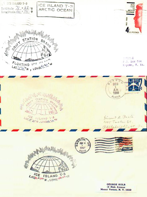 [Image: Letters postmarked from Drift Station Bravo, via
 [Images: Postal marking and a letter from Drift Station Bravo, via
 [Images:
  [Image: Downtown Reno on a Saturday night with people queuing up to climb the BaseCamp wall; photo by BLDGBLOG].
 [Image: The wall; photo by BLDGBLOG].
 [Image: The wall; photo by BLDGBLOG].
 [Image: The
  [Image: The
  [Images: An artificial ice structure by
  [Image: Disguised infrastructure; photo by BLDGBLOG].
 [Image: The door to the underworld; photo by BLDGBLOG].
 [Image: Disguised infrastructure; photo by BLDGBLOG].
 [Image: A view through the front door of 58 Joralemon Street; photo by BLDGBLOG].
 [Image: Photo by BLDGBLOG].
 [Image: Two views of the tunnel vent on Governors Island; photos by BLDGBLOG].
 [Image: Holland Tunnel exhaust tower; photo via
  [Image: The Holland Tunnel Land Ventilation Building, courtesy of
  [Image: The house on Joralemon Street; photo by BLDGBLOG].
 [Image: An otherwise unrelated image of the unmanned
 [Images: Might semi-autonomous systems such as this someday track residential property lines? Images courtesy of
  [Image: Assembling the 7-mile rainbow one ring at a time, by Ben Masterton-Smith].
 [Image: Assembling the rainbow; images by Ben Masterton-Smith].
 [Image: The glorious 7-mile rainbow takes form].
 [Images: Rainbow diagrams by Ben Masterton-Smith].
 [Image: The rainbow under construction; image by Ben Masterton-Smith].
 [Image: From the


 [Images: From the
  [Image: The erstwhile basement hibernator, photographed by Brendan Kuty/Patch.com, via
  [Image: The
  [Images: Photos of Picher's artificial landforms, courtesy of the
 [Images: A


 [Images: Sections through the
  [Image: Inside the "


