|
|
 [Image: Jasper National Park, courtesy of Parks Canada]. [Image: Jasper National Park, courtesy of Parks Canada].
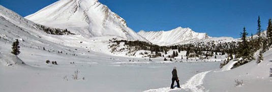
There's an interesting article over at Highline Magazine about a lost hiker named George Joachim whose subsequent behavior in the landscape was so spatially unexpected that he eluded discovery for ten days.
He was a "behavioral outlier," we read, and his mathematically unpredictable actions forced a revision of what is, in effect, the search algorithm used by Parks Canada for tracking human beings in the wild.
 [Image: Jasper National Park, courtesy of Parks Canada]. [Image: Jasper National Park, courtesy of Parks Canada].
From the story:
Parks Canada uses a statistical model to help predict where the lost person might be. The model uses data collected from similar lost person cases to learn the size and location of the search area. Combining the experience of the searchers and research on the lost person, the model then suggests the likelihood the person will be in various locations based on how previous people in their situation have behaved.
Joachim unintentionally misled searchers by listing his destination incorrectly in the climber’s registry, and then behaved so unlike other people previously have in his circumstance that he was repeatedly missed in the search. Parks Canada’s search and rescue community considers his case a valuable learning experience and have since tweaked search protocols to account for other behavioral outliers. Put another way, this hiker exceeded the agent-based mathematical model used to track him. As a result, his searchers were forced to develop what the author calls the "Joachim profile," a kind of makeshift simulation that, in theory, should have been able to predict where he'd pop up next.
The idea that human movement through the wilderness corresponds—or not, as the case may be—to a mathematical sorting algorithm is fascinating, especially when that model diverges so drastically from what a person really does out there.
In fact, it's worth speculating that it is precisely in this divergence from accepted mathematical models of landscape use where we can find a truer or more "wild" experience of the terrain—as if certain activities can be so truly "wild" that no known algorithm is capable of describing them.
 [Image: Jasper National Park, courtesy of Parks Canada]. [Image: Jasper National Park, courtesy of Parks Canada].
In any case, it's by no means the world's most gripping story of human survival, but it's a great example of human landscape expectations and the limits of abstract modeling. Click over to Highline to read the whole thing.
 [Image: A drone from DJI]. [Image: A drone from DJI].
It's hardly surprising to read that drones can be repurposed as burglars' tools; at this point, take any activity, add a drone, and you, too, can have a news story (or Kickstarter) dedicated to the result.
"Why not send an inexpensive drone, snoop in your windows, see if you have any pets, see if you have any expensive electronics, maybe find out if you have any jewelry hanging around," a security expert wonders aloud to Hawaii's KITV, describing what he sees as the future of burglary. Burglars "can do all that with a drone without ever stepping a foot on your property line."
"So what's a homeowner to do?" the TV station asks.
They suggest following the drone back to its owner, who, due both to battery life and signal range, will be nearby; or even installing "new expensive high-tech drone detection systems that claim to detect the sounds of a drone's propellers." This is absurd—suggesting that some sort of drone alarm will go off at 3am, driving you out of bed—but it's such a perfectly surreal vision of the suburbs of tomorrow.
Fortifying our homes against drone incursion will be the next bull market in security: whole subdivisions designed to thwart drone flights, marketed to potential homeowners specifically for that very reason.
You go home for the weekend to visit your parents where, rather than being enlisted to mow the lawn or clean the gutters, you're sent you out on drone duty, installing perimeter defenses or some sort of jamming blanket, an electromagnetically-active geotextile disguised beneath the mulch. Complex nets and spiderweb-like antennas go on sale at Home Depot, perfect for snaring drone rotors and leading to an explosion in suburban bird deaths.
 [Image: A drone from DJI]. [Image: A drone from DJI].
This news comes simultaneously with a story in Forbes, where we read that drone manufacturer DJI is implementing a GPS block on its products: they will no longer be able to fly within 15.5 miles of the White House.
The company is issuing "a mandatory firmware update to all Phantom drones that will restrict flight within a 15.5 mile radius centered around downtown Washington D.C. Pilots looking to operate their Phantom drone will not be able to take off or fly within the no-fly-zone." Based off a drone’s GPS coordinates, the technology to geo-fence drones from entering a particular airspace, especially around major airports, has been around in Phantoms since early last year. The new update will add more airports to its no-fly-zone database as the 709 no-fly-zones already in the Phantom’s flight controller software will expand to more than 10,000, with additional restrictions added to prevent flight across national borders.
This is remarkable for a number of reasons, not the least of which is the fact that firmware updates and geography now work together to disable entire classes of products within a given zone or GPS range. Put another way, drones today—but what tomorrow?
Geofencing or "locationized" firearms have already been discussed as a possible future form of gun control, for example, and it would not be at all surprising to see "locationized" smartphones or geofenced cameras becoming a thing in the next few years.
All a government (or criminal syndicate) would have to do is release a (malicious) firmware update, temporarily shutting down certain types of electronics within range of, say, a presidential inauguration (or a bank heist).
 [Image: A drone from DJI]. [Image: A drone from DJI].
More to the point of this post, however, GPS-based geofencing will also become part of the electromagnetic armature of future residential developments, a new, invisible layer of security for those who are willing to pay for it.
Think, for example, of the extraordinary geographic dazzle effects used by government buildings to camouflage their real-world locations: as Dana Priest and William Arkin wrote for The Washington Post back in 2012, "most people don't realize when they're nearing the epicenter of Fort Meade's, even when the GPS on their car dashboard suddenly begins giving incorrect directions, trapping the driver in a series of U-turns, because the government is jamming all nearby signals."
If half the point of living in the suburbs is to obtain a certain level of privacy, personal safety, and peace of mind, then it is hardly science fiction to suggest that the electromagnetic fortification of suburbia is on the immediate horizon.
You won't just turn on a burglar alarm with your handy smartphone app; you'll also switch on signal-jamming networks hidden in the trees or a location-scrambling geofence camouflaged as a garden gnome at the edge of your well-mown lawn. Drones, dazzled by invisible waves of unpredictable geographic information, will perform U-turns or sudden dives, even racing off to a pre-ordained security cage where they can be pulled from the air and disabled.
The truly high-end residential developments of tomorrow will be electromagnetically fortified, impervious to drones, and, unless you've been invited there, impossible for your cars and cellphones even to find.
 [Image: From "Mining Cenotaph" by Alexis Quinteros Salazar; courtesy of the RIBA President's Medals]. [Image: From "Mining Cenotaph" by Alexis Quinteros Salazar; courtesy of the RIBA President's Medals].
Here's another project from the RIBA President's Medals, this one by Alexis Quinteros Salazar, a student at the University of Chile in Santiago.
Called " Mining Cenotaph," it imagines an "occupation" of the tailings piles that have become a toxic urban landmark and a spatial reminder of the region's economic exploitation.
 [Image: From "Mining Cenotaph" by Alexis Quinteros Salazar; courtesy of the RIBA President's Medals]. [Image: From "Mining Cenotaph" by Alexis Quinteros Salazar; courtesy of the RIBA President's Medals].
A museum would be carved into the tailings; in Salazar's words, this would be a "building that captures the history and symbolism behind mining, enhancing and revitalizing a memory that is currently disaggregated and ignored and has a very high touristic potential."
 [Image: From "Mining Cenotaph" by Alexis Quinteros Salazar; courtesy of the RIBA President's Medals]. [Image: From "Mining Cenotaph" by Alexis Quinteros Salazar; courtesy of the RIBA President's Medals].
In an architectural context such as this, the use of the word "cenotaph" is a pretty clear reference to Étienne-Louis Boullée's classic speculative project, the " Cenotaph for Newton." Over multiple generations, that has become something of a prime mover in the history of experimental architectural design.
Punctured walls and ceilings bring light into the interior—
 [Image: From "Mining Cenotaph" by Alexis Quinteros Salazar; courtesy of the RIBA President's Medals]. [Image: From "Mining Cenotaph" by Alexis Quinteros Salazar; courtesy of the RIBA President's Medals].
—while the roof is a recreational space for visitors.
Of course, there are a lot of unanswered questions here—including the control of aerosol pollution from the tailings pile itself and that pile's own long-term structural stability—but the poetic gesture of a public museum grafted into a pile of waste material is worth commending.
 [Image: From "Mining Cenotaph" by Alexis Quinteros Salazar; courtesy of the RIBA President's Medals]. [Image: From "Mining Cenotaph" by Alexis Quinteros Salazar; courtesy of the RIBA President's Medals].
The detail I might like this most is where the structure becomes a kind of inversion of Boullée's dome, which was pierced to make its huge interior space appear illuminated from above by constellations. Here, instead, it is the perforations in the the rooftop that would glow upward from below, as if in resonance with the night skies high above.
 [Image: From "Mining Cenotaph" by Alexis Quinteros Salazar; courtesy of the RIBA President's Medals]. [Image: From "Mining Cenotaph" by Alexis Quinteros Salazar; courtesy of the RIBA President's Medals].
Salazar's project brings to mind a few other proposals seen here over the years, including the extraordinary " Memorial to a Buried Village" by Bo Li and Ge Men, as well as Brandon Mosley's " Mine Plug" (which actually took its name retroactively from that BLDGBLOG post).
Click through to see slightly larger versions of the images over at the RIBA President's Medals website.
 [Image: From "Mining Cenotaph" by Alexis Quinteros Salazar; courtesy of the RIBA President's Medals]. [Image: From "Mining Cenotaph" by Alexis Quinteros Salazar; courtesy of the RIBA President's Medals].
Finally, don't miss the Brooklyn food co-op posted earlier, also a recent President's Medal featured project.
 [Photo: "Mega Bike" at the Louisville Mega Cavern; photo courtesy Louisville Mega Cavern]. [Photo: "Mega Bike" at the Louisville Mega Cavern; photo courtesy Louisville Mega Cavern].
An underground bike park is opening up next month in a former limestone mine 100 feet beneath Louisville, Kentucky.
At 320,000-square feet, the facility is massive. Outside Magazine explains, "the park will have more than five miles of interconnected trails that range from flowing singletrack to dirt jumps to technical lines with three-foot drops. And that’s just the first of three phases to roll out this winter."
 [Photo: "Mega Bike" at the Louisville Mega Cavern; photo courtesy Louisville Mega Cavern]. [Photo: "Mega Bike" at the Louisville Mega Cavern; photo courtesy Louisville Mega Cavern].
That's from an interview that Outside just posted with the park's designer, Joe Prisel, discussing things like the challenges of the dirt they've had to use during the construction process and the machines they used to sculpt it.
 [Photo: "Mega Bike" at the Louisville Mega Cavern; photo courtesy Louisville Mega Cavern]. [Photo: "Mega Bike" at the Louisville Mega Cavern; photo courtesy Louisville Mega Cavern].
It's not the most architecturally-relevant interview, if I'm being honest, so there's not much to quote here from it, but the very idea of a BMX super-track 10 stories underground in a limestone mine sounds like a project straight out of an architecture student's summer sketchbook, and it's cool to see something like this become real.
 [Image: From "Brooklyn Co-operative" by Yannis Halkiopoulos, University of Westminster; courtesy RIBA President's Medals]. [Image: From "Brooklyn Co-operative" by Yannis Halkiopoulos, University of Westminster; courtesy RIBA President's Medals].
I was clicking around on the RIBA President's Medals website over the weekend and found a few projects that seemed worth posting here.
The one seen here is a beautifully illustrated proposal for an "alternative supermarket" in Brooklyn, New York, that would be located in the city's old Navy Yard.
Note that, in all cases, larger images are available at the project website.
 [Image: From "Brooklyn Co-operative" by Yannis Halkiopoulos, University of Westminster; courtesy RIBA President's Medals]. [Image: From "Brooklyn Co-operative" by Yannis Halkiopoulos, University of Westminster; courtesy RIBA President's Medals].
Its designer—Yannis Halkiopoulos, a student from the University of Westminster—pitches it as a food-themed exploration of adaptive reuse, a mix of stabilized ruins, gut renovations, and wholly new structures.
He was inspired, he suggests, by the architecture of barns, market structures, and the possibility of an entire urban district becoming a "reinvented artefact" within the larger economy of the city.
The results would be a kind of post-industrial urban food campus on the waterfront in Brooklyn.
 [Image: From "Brooklyn Co-operative" by Yannis Halkiopoulos, University of Westminster; courtesy RIBA President's Medals]. [Image: From "Brooklyn Co-operative" by Yannis Halkiopoulos, University of Westminster; courtesy RIBA President's Medals].
From Halkiopoulos's description of the project: The project is a response to current plans which are to demolish the row of abandoned houses to build a suburban supermarket. Once home to high ranking naval officers the eleven structures have been left to decay since 1960. The response is an alternative food market which aims to incorporate the row of houses and re-kindle the consumer with the origin of the food produced and promote regional traditions, gastronomic pleasure and the slow pace of life which finds its roots in the Slow Food Movement NY. It includes a slaughterhouse, a "slow fish market," preservation facilities, a "raised tunnel network" linking the many buildings, and more.
 [Image: From "Brooklyn Co-operative" by Yannis Halkiopoulos, University of Westminster; courtesy RIBA President's Medals]. [Image: From "Brooklyn Co-operative" by Yannis Halkiopoulos, University of Westminster; courtesy RIBA President's Medals].
The buildings as a whole are broken down tectonically and typologically, then further analyzed in their own posters.
 [Image: From "Brooklyn Co-operative" by Yannis Halkiopoulos, University of Westminster; courtesy RIBA President's Medals]. [Image: From "Brooklyn Co-operative" by Yannis Halkiopoulos, University of Westminster; courtesy RIBA President's Medals].
There is, for example, the "slaughterhouse & eating quarters" building, complete with in-house "whole animal butcher shop," seen here—
 [Image: From "Brooklyn Co-operative" by Yannis Halkiopoulos, University of Westminster; courtesy RIBA President's Medals]. [Image: From "Brooklyn Co-operative" by Yannis Halkiopoulos, University of Westminster; courtesy RIBA President's Medals].
—as well as the "slow fish market" mentioned earlier.
 [Image: From "Brooklyn Co-operative" by Yannis Halkiopoulos, University of Westminster; courtesy RIBA President's Medals]. [Image: From "Brooklyn Co-operative" by Yannis Halkiopoulos, University of Westminster; courtesy RIBA President's Medals].
Most of these use exposed timber framing to imply a kind of unfinished or incompletely renovated condition, but these skeletal grids also work to extend the building interiors out along walking paths and brise-soleils, partially outdoor spaces where food and drink could be consumed.
These next few images are absurdly tiny here but can be seen at a larger size over at the President's Medals; they depict the stabilized facades of the homes on Admirals Row, including how they might change over time.
   [Images: From "Brooklyn Co-operative" by Yannis Halkiopoulos, University of Westminster; courtesy RIBA President's Medals]. [Images: From "Brooklyn Co-operative" by Yannis Halkiopoulos, University of Westminster; courtesy RIBA President's Medals].
Part of this would include the installation of a "raised tunnel network," effectively just a series of covered walkways and pedestrian viaducts between buildings, offering a visual tour through unrenovated sections of the site but also knitting the overall market together as a whole.
  [Images: From "Brooklyn Co-operative" by Yannis Halkiopoulos, University of Westminster; courtesy RIBA President's Medals].
In any case, I really just think the images are awesome and wanted to post them; sure, the project uses a throwback, sepia-toned, posterization of what is basically just a shopping center to communicates its central point, but the visual style is actually an excellent fit for the proposal and it also seems perfectly pitched to catch the eye of historically minded developers.
You could imagine Anthony Bourdain, for example, enjoying the sight of this for his own forthcoming NY food market.
 [Image: From "Brooklyn Co-operative" by Yannis Halkiopoulos, University of Westminster; courtesy RIBA President's Medals]. [Image: From "Brooklyn Co-operative" by Yannis Halkiopoulos, University of Westminster; courtesy RIBA President's Medals].
In a sense, it's actually too bad this didn't cross their desks; personally, I wouldn't mind hopping on the subway for a quick trip to the Navy Yard, to wander around the revitalized ruins, now filled with food stalls and fish mongers, walking through gardens or stumbling brewery to brewery on a Saturday night, hanging out with friends amidst a labyrinth of stabilized industrial buildings, eating fish tacos in the shadow of covered bridges and tunnels passing overhead.
More (and larger) images are available over at the President's Medals.
 [Image: Photographer unknown, via Root Blog]. [Image: Photographer unknown, via Root Blog].
Via some indirect links following an email tip from Sam Grawe, I stumbled on this collection of ambient music "mostly emanating from the corporate infrastructure of the 1980s asset bubble. FM synthesis, prefab 'lifestyle' soundscapes and the illusion of nature in a hyper-urban environment."
It's music as the icing on the space—a sonic introduction to new forms of interiority, smoothing your transition into supermodernity—or soundtracks for architecture in an age of capital accumulation. New Age meets non-place. Imagine a room that makes no sense until you play the right music in it.
While you're listening, however, don't miss this album composed by digital music pioneer Hiroshi Yoshimura for a " commission by the Shiseido cosmetic corporation to promote a forest-scented perfume (the LP comes in a plastic bag sealed with its scent)." The nested layers of representation and artificiality here are amazing.
Perhaps someone should write a thesis on the ornamental evolution of the New Age interior, moving from the Spaced Out drop cities of Alastair Gordon's book to a sparsely furnished apartment somewhere in the sprawl of 1980s Tokyo where an insomnia-wracked executive stares at a bleeping digital toy in a state of Zen-like concentration, the sound of synthetic rain forests playing on hidden speakers embedded in the wall.
(Thanks, Sam!)
 [Image: Courtesy of Icecave Iceland]. [Image: Courtesy of Icecave Iceland].
There's an interesting construction/excavation project going on over in Iceland right now: an artificial tunnel and cave complex being dug into the Langjökull Glacier.
When complete, the publicly accessible infra-glacial facility "will consist of numerous nooks and dens which will house exhibitions, information, restaurants and even a small chapel for those who would like to marry deep within an ice cap."
Bringing tourists nearly 100 feet below the surface of the glacier, the structure is expected to become semi-permanent, lasting through the summer months for years to come.
 [Image: Courtesy of Icecave Iceland]. [Image: Courtesy of Icecave Iceland].
The so-called " Icecave" is set to open later this year, and is not far from Reykjavik; for now, its entrance consists only of some understated plywood framing, with no real indication of what awaits below—or within, as the case may be.
 [Image: Courtesy of Icecave Iceland]. [Image: Courtesy of Icecave Iceland].
But tunnels, bays, and side chambers are currently under construction, being chipped down by excavation equipment and drills, and then further shaped by hand tools.
 [Image: Courtesy of Icecave Iceland]. [Image: Courtesy of Icecave Iceland].
I love the idea that all of this is essentially doomed—that the chambers will eventually collapse or melt, even if only decades from now, and that the glacier itself will presumably someday refreeze, free of all these spatial abnormalities.
At which point, the architecture of subtraction could simply start all over again, like a 3-dimensional Etch-a-Sketch of brand new ramps, tunnels, and stairs, all burrowing down toward bedrock. A ritually renewed space, a kind of negative Ise Shrine in the ice.
Or perhaps we need a Mole Man of the Glacier.
In any case, lights are now being installed in the walls, giving the place an otherworldly glow that comes from within the structure itself—
 [Image: Courtesy of Icecave Iceland]. [Image: Courtesy of Icecave Iceland].
—with the truly awesome effect that nearby rooms will seem to glow through the ice walls, revealing themselves as illuminated shapes, even appearing to shine through the floors and ceilings.
This same strategy, using frosted glass floors, walls, and ceilings, in a building otherwise made from dark-stained timber or masonry, would be beautiful.

 [Images: Courtesy of Icecave Iceland].
Meanwhile, huge ducts like something out of a frozen warehouse or sub-glacial military base criss-cross the frozen ceilings and extend deeper into the glacier.
 [Image: Courtesy of Icecave Iceland]. [Image: Courtesy of Icecave Iceland].
Indeed, I'm reminded of the incredible story of Camp Century—or Project Iceworm—a U.S. military city built under the ice of northwestern Greenland. Here's a video about it, if you're curious:
As explored on BLDGBLOG back in 2011, Camp Century was a sprawling complex of prefabricated architectural units and steel arches installed within the ice cap, and, astonishingly, it was powered by a portable nuclear reactor.
  [Images: Camp Century under construction; photographs via Frank J. Leskovitz]. [Images: Camp Century under construction; photographs via Frank J. Leskovitz].
In any case, the Langjökull excavations are meant to finish up later this year; check back on the Icecave homepage for its opening date.
|
|


