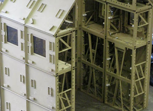
I was excited to see that Matthew Coolidge, of the Center for Land Use Interpretation (CLUI), will be speaking at Pratt tomorrow night, Monday, February 22nd, in Brooklyn. His subject is "Anthropogeomorphology Today." The talk starts at 6pm, is free and open to the public, and starts at 6pm. Just head over to Higgins Hall at the Pratt Institute: 60 St. James Place, near the corner of Lafayette. Here is a map.
CLUI's exhibitions are always worth checking out in detail, as are their field trips through the American landscape. Meanwhile, for an infrastructural tour of Los Angeles, guided by Coolidge, check out an old article I wrote for Dwell.
Two years ago, Colleen Morgan of Middle Savagery pointed out these amazing tactile maps of the Inuit, "3D wood carvings of the East Greenland coastline, with the details of inlets and islands in sculptural relief. These could be employed by [travelers] at night in conjunction with the stars, feeling your way along the coastline, navigating at an intimate scale."
She compares these to Braille maps for the blind—which I would further compare to the embossing printer used by a blind architect in San Francisco to produce tactile building plans. "He began drawing with Wikki Stix," the L.A. Times reported last month, "strands of wax-covered yarn that adhere to paper with just a little pressure. His most useful tool became a large-format embossing printer, which turns blueprints into raised line drawings that he can read with his fingertips."
As if using the Inuit maps pictured above, he simply runs his fingers along the creased lines of rooms and hallways, and buildings take shape in their every variation around him.
Briefly diverging here, I was fascinated to read elsewhere in that same article about the subtle architectural design cues that can be deployed for the blind or visually impaired. For instance, the architect once "collaborated on a room-numbering system to help blind students navigate the building. The facility will use different textured flooring in a few key areas so students can tell where they are by the tap of a cane." Further, "blind students who descend a staircase that deposits them in the middle of a vast lobby will be able to find their way because the ceiling will be enhanced, at [the architect's] suggestion, to create an acoustic corridor to the door." Designing "acoustic corridors" across the city sounds like a superb design challenge (as well as something that could be of much wider use in the event of prolonged urban blackouts).
In any case, like Middle Savagery, I am fascinated by the other applications these sorts of handheld, tactile maps might have—where else they might be useful and what other spaces they might be able to represent. Could there be a tactile map of a novel's plotline, or or the New York City subway system, or of the Appalachian Trail? What about of your own apartment, or the house you grew up in? Could there be tactile cinema? Could you make a tactile map of a song?
Like a culinary version of Sourcemap, Rebar has teamed up with landscape architect David Fletcher and some students from the increasingly interesting California College of the Arts in San Francisco to explore the ingredients of your local taco—from pinto beans to the aluminum foil it all comes wrapped in.
Our premise was that a seemingly simple, familiar food like the taco truck taco could provide visceral insight into the connections between the systems we were exploring [in our studio's investigation of the city]. By thoroughly learning the process of formation and lifecycle for what it takes to make a taco, we would be better able to propose and design a speculative model of a holistic and sustainable urban future. What resulted was a richly complex network of systems, flows and ecologies that we call the global Tacoshed.
This is a participatory undertaking; meet at the Studio for Urban Projects in San Francisco at 7pm on Thursday, February 25, to find out how you, too, can map a taco. Here's a map.
The Studio for Urban Projects, meanwhile, has a pretty fascinating list of previous endeavors, including Foodshed, Strange Weather, and the awesome Unnatural History of Golden Gate Park. Large parts of what are now west San Francisco were once covered by nomadic sand dunes, a kind of peninsular erg; that granular presence is now only temporarily locked in place beneath the foundations of houses. Every grain you see blowing down a San Franciscan street is this lost geography attempting to reassert itself.
Beneath your feet, San Francisco, something ancient is patiently waiting.
[Image: "There are two basic types of taco trucks," we read; "the first and most common is the transient truck which is a truck that stops at approximately 20 different locations at 20-minute intervals during an 8-hour shift, typically beginning at 6am and ending at 2pm. The second type is the semi-permanent truck, which is a truck that has found a location that has a density of clientele to sustain it for an extended period of the day, creating a nearly fixed presence in a particular community." From Polar Inertia].
And I can't let this post end without calling attention to the excellent—in fact, extraordinary—Polar Inertia, specifically its photo-essay published more than four years ago tracing the taco-truck geography of greater Los Angeles. These dispersed infrastructures might now be quite trendy, but the functional networks things like taco trucks actually form on the streets of our cities are still worth mapping in full.
(On an unrelated note, my older brother apparently wanted to name me "Taco"—not Geoff—but my parents, luckily, got to decide).
1)Constructed Territory: "A juried exhibition of work integrating the use of maps, cartography, or environmental and topographical explorations." Submissions due: May 14, 2010.
2)made up: "This call welcomes designers, filmmakers, architects, scholars, researchers, and artists to submit proposals for design-driven research projects to be conducted in Summer 2010 in the Graduate Media Design Program studio [at the Art Center College of Design in sunny Pasadena]. We are looking for projects that are motivated by research questions and that use design/making as a mode of inquiry. We are particularly interested in projects that address the theme 'made up' which explores the role of fiction in design." Submissions due: March 23, 2010.
3)Mine the Gap: "An international design ideas competition dedicated to examining one of the most visible scars left after the collapse of the real estate market in Chicago: the massive hole along the Lake Michigan shore that was to have been—and may yet be—the foundation for a singular 150-story condominium tower designed by an internationally-renowned Spanish architect, a tower which was to have become a new icon for the city and region. What to do with the gap?" Submissions due: "anytime between March 22, 2010 and May 3, 2010."
4)All That Glitters Is Good: "How do you prepare your architectural drawings? What mediums do you allow yourself in your quest to explain three dimensional intent and ideas on a two dimensional surface? Answer truthfully, when was the last time you did anything beyond hitting print?
All That Glitters Is Good asks you to submit your most accomplished architectural representation that uses glitter. This includes new drawings made with glitter, old drawings pepped up with a little sparkle, as well as anything else that you can imagine so long as it satisfies two criteria:
1. It’s a drawing of architecture. 2. It uses glitter."
Submissions due: March 15, 2010.
5) You just missed: GOOD magazine, Studio-X, and PRE Office teamed up to judge Spontaneous Architecture—the results of which can be seen at that latter link. For some background to that call-for-ideas, read Studio-X's Gavin Browning debate with Cameron Sinclair about the efficacy of design competitions inspired by natural disasters over at Building Design. While you're there, refresh your memory about Building Design's stance on climate change.
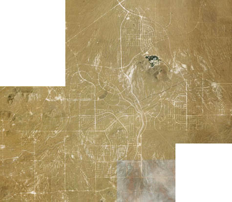
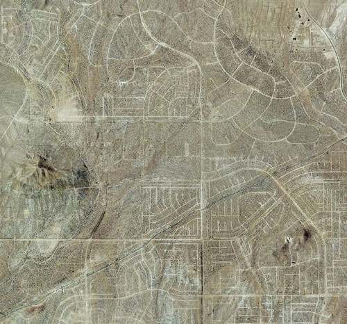
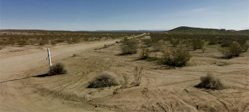
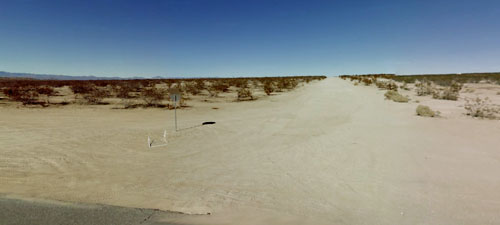
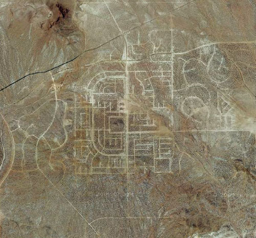
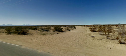
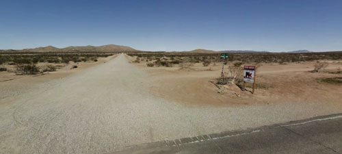
In the desert 100 miles northeast of Los Angeles is a suburb abandoned in advance of itself—the unfinished extension of a place called California City. Visible from above now are a series of badly paved streets carved into the dust and gravel, like some peculiarly American response to the Nazca Lines (or even the labyrinth at Chartres cathedral). Bill & Ted meet Cerne Abbas Man.
The uninhabited street plan has become an abstract geoglyph—unintentional land art visible from airplanes—not a thriving community at all.
On Google Street View, distant structures like McMansions can be made out here and there amidst the ghost-grid, mirages of suburbia in the middle of nowhere. Meaningless STOP signs stand guard over dead intersections.
And it's a weird geography: two of the most prominent nearby landmarks include a prison and an automobile test-driving facility run by Honda. There is also a visually spectacular boron mine to the southeast—it's the largest open-pit mine in California, according to the Center for Land Use Interpretation—and an Air Force base.
To make things more surreal, in an attempt to boost its economic fortunes, California City hired actor Erik Estrada, of CHiPs fame, to act as the town's media spokesperson.
The history of the town itself is of a failed Californian utopia—in fact, incredibly, if completed, it was intended to rival Los Angeles. From the city's Wikipedia entry:
California City had its origins in 1958 when real estate developer and sociology professor Nat Mendelsohn purchased 80,000 acres (320 km2) of Mojave Desert land with the aim of master-planning California's next great city. He designed his model city, which he hoped would one day rival Los Angeles in size, around a Central Park with a 26-acre (11 ha) artificial lake. Growth did not happen anywhere close to what he expected. To this day a vast grid of crumbling paved roads, scarring vast stretches of the Mojave desert, intended to lay out residential blocks, extends well beyond the developed area of the city. A single look at satellite photos shows the extent of the scarred desert and how it stakes its claim to being California's 3rd largest geographic city, 34th largest in the US. California City was incorporated in 1965.
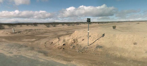
Note, however, that this is not a guided tour; it is simply an organized simultaneity of people all going out to investigate these streets en masse. Armed with cameras, microphones, sketchbooks, GPS devices, quickly scrawled notes for future blog posts, and more, we'll be exploring the site at our own pace, perhaps even miles apart at various times. This is not a guided tour with an expert on the area.
As such, all questions of transportation (including tires suitable for travel over unsealed dirt roads); adequate food, fuel, and water; personal safety (including protection from sprained ankles and snakes); and navigation are up to individual participants.
We will meet at 1pm on Saturday, March 20, 2010, in the parking lot of Rite Aid in California City: 9482 California City Boulevard, California City, CA 93505. There will be a very brief group introduction there—and you can run inside to buy Cokes or whatever—before we set off to document the uninhabited streets outside town. Let's photograph, film, blog, Lomo, Twitter, and audio-record the crap out of this place! I've started a Flickr group, which will be opened up soon. If you arrive late, simply head out Randsburg Mojave Road, onto 20 Mule Team Parkway, and look for the cars; our eventual cluster of destinations is approximately 15 minutes’ drive northeast of town.
And, in the unlikely event of torrential rains, I will post travel updates here on BLDGBLOG.
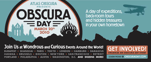
Meanwhile, the incomparable Atlas Obscura has a whole slew of amazing trips planned for March 20, all over the world, all part of their first annual "Obscura Day." Definitely check out that list for sites closer to you, if you're not in southern California.
(California City was originally pointed out to me by David Donald, and it was written up by The Vigorous North last year. The "cannabis city" and solar farm links come courtesy of Alexis Madrigal. All images in this post via Google Maps and Google Street View).
During the New York City blackout of 1965, roughly "one thousand overseas passengers were affected," the New York Times reported at the time, and "many of them were put up in nearby hotels or motels."
A slightly different scenario unfolded at the city's airports, however:
At Kennedy, American Airplanes rolled out all its planes, which are equipped with independent power systems, and loaded eight hundred stranded passengers. They were fed a meal and shown motion pictures until the lights came back.
These self-powered moving rooms—airplanes become hotels become cinemas become emergency shelters, in a jet-setting transformational sequence like something out of the early visions of Archigram—revealed an unexpected flexibility to the infrastructure of global transport.
Next time, perhaps, when the lights go out in your own home city, that jumbo jet parked nearby on an airport runway will be the best place for you to go: an aboveground disaster shelter, independent from the grid whose loss it temporarily saves you from.
(You can watch a short video about the blackout, courtesy of James Burke; here is part one).
The opening scene of The Forever War by Dexter Filkins presents us with the sight of U.S. soldiers preparing for their invasion of Falluja. Filkins is there to witness the attack; amidst the growl of tanks and Humvees, and "by the light of airstrikes and rockets," he writes, there is suddenly something sonically unexpected.
[Image: "An Advanced Individual Training Soldier in the Psychological Operations Specialist Course attaches a loud speaker on top of a High Mobility Multi-Wheeled Vehicle, or HUMVEE, at Forward Operating Base Freedom, Camp MacKall, N.C." Courtesy of the John F. Kennedy Special Warfare Center and School].
"And then, as if from the depths," Filkins writes, "came a new sound: violent, menacing and dire."
I looked back over my shoulder to where we had come from, into the vacant field at Falluja's northern edge. A group of marines were standing at the foot of a gigantic loudspeaker, the kind used at rock concerts.
It was AC/DC, the Australian heavy metal band, pouring out its unbridled sounds. I recognized the song immediately: "Hells Bells," the band's celebration of satanic power, had come to us on the battlefield.
While by no means advocating the use of sonic warfare as a tool in U.S. military adventures or police operations, I nonetheless instantly thought of this scene—of armed soldiers holding aloft rock-blaring boom boxes, like some John Milius-directed remake of Say Anything—when I read, in a very different context, that bark beetles can be driven out of the pine forests they currently infest if you play digitally-altered sounds of their own chewing back at them through loud speakers. The high-volume sound of themselves drives them away.
A research assistant suggested using sounds to aggravate the beetles, much as police sometimes blare music in hostage situations. The researchers tried Queen and Guns N' Roses and played snippets of radio talker Rush Limbaugh backward. None produced the desired results.
Then, the beetles were exposed to digitally altered recordings of their own calls, the sounds they make to attract or repel other beetles. The response was immediate. The beetles stopped mating or burrowing. Some fled, helter-skelter. Some violently attacked each other.
Most important, they stopped chewing away at the pine tree, suggesting that the scientists may have discovered a sort of sonic bullet that could help slow the beetles' destructive march.
Again, I do not mean to imply that infestation metaphors are the most appropriate to use when discussing Operation Phantom Fury, or that military action in that city was analogous to clearing a forest of bark beetles; but the audio possibilities here, and the specifics of the set-up, seem amazing.
[Image: A ponderosa pine forest; within those trunks might be beetles].
More about the actual experiment, run at Northern Arizona University's Forestry Lab:
They collected tree trunks infested with bark beetles... Working in the lab, [research assistant Reagan McGuire] piped in the music through tiny speakers, the sort you might find in a singing greeting card. He watched the reaction of the beetles using a microscope. The rock music didn't seem to annoy the bugs, nor did Rush in reverse.
McGuire and [Northern Arizona University forest entomologist Richard Hofstetter] decided to try something different. They recorded the sounds of the beetles and played them back, manipulating them to test the response.
Suddenly, every little thing they did seemed to provoke the beetles.
"We could use a particular aggression call that would make the beetles move away from the sound as if they were avoiding another beetle," Hofstetter said.
When they made the beetle sounds louder and stronger than a typical male mating call, he said, the female beetle rejected the male and moved toward the electronic sound.
These audio simulations, in other words, had demonstrable physical effects on another species; their own warped sonic portrait drove them crazy.
So could you reprogram your Marsona 1288A ("create a personalized sound environment") with the digitally-altered ambient sounds of termites and thus clear your house of insectile pests? The USDA, after all, has published a paper—download the PDF—explaining how a "portable, low-frequency acoustic system was used to detect termite infestations in urban trees." Indeed, "termite sounds could be detected easily underneath infested trees, despite the presence of high urban background noise." So why not reverse this—drive them out of the city using weird MP3s specially produced for boom cars?
Perhaps we should petition Clear Channel or Sirius XM to premiere a new, insect-only broadcast hour, killing ants and roaches in every city where it's played (or perhaps just driving them all out, streaming from the floorboards, in a moment of utter horror).
I'm reminded here of the famous example of Sgt. Pepper's Lonely Hearts Club Band by The Beatles, with its "dog whistle—which humans can't hear—buried on the album's second side." Only, in our case, it would be a different kind of beetle-whistle, and one with anti-infestational effects.
Danger Room: "As part of its budget for the upcoming fiscal year, Pentagon extreme research agency Darpa is launching the Transparent Earth project. They’ll invest $4 million into the creation of real-time, 3-D maps that display 'the physical, chemical, and dynamic properties of the earth down to 5 km depth, including natural or man-made structures at militarily-relevant spatial scales.'"
InfraNet Lab: "When snow prospects at lower Cypress looked dim, the Vancouver Organizing Committee (VANOC) unrolled the contingency plan to use snowcats, trucks, helicopters and a team of about 45 people to equitably redistribute snowfall. This led to two basic weather engineering practices: snow transfer and snow-base packing. Trucks and snowcats are moving snow from higher elevations, while helicopters are ferrying in bales of straw to bolster bases, walls and turns. Snow is being moved hastily—none of the ice brick techniques found at Innsbruck here—almost more as a cut-fill soil strategy. VANOC is trucking in about three dozen loads of snow a day from as far away as Manning Park, more than two hours drive east of Vancouver. That is over 300 truckloads and counting."
[Image: Snow-hardening in Olympic Vancouver; photo by Jae C. Hong courtesy of the Associated Press (via InfraNet Lab)].
e360: "A group of solutions is emerging under the rubric of 'rewilding,' and this new movement has made considerable progress over the past decade. A Marshall Plan for the environment, rewilding promotes the expansion of core wilderness areas on a vast scale, the restoration of corridors between them (to fight the 'island' effect of isolated parks and protected areas), and the reintroduction or protection of top predators."
New York Times: "Dirty flags advertise rock-bottom discounts on empty starter mansions. On the ground, foreclosure signs are tagged with gang graffiti. Empty lots are untended, cratered with mud puddles from the winter storms that have hammered California’s San Joaquin Valley. Nobody is home in the cities of the future."
[Image: Rho Ophiuchus. Photo courtesy Spitzer Space Telescope/NASA].
PhysOrg.com: "According to Michael Mautner, Research Professor of Chemistry at Virginia Commonwealth University, seeding the universe with life is not just an option, it’s our moral obligation... 'We have a moral obligation to plan for the propagation of life, and even the transfer of human life to other solar systems which can be transformed via microbial activity, thereby preparing these worlds to develop and sustain complex life.'"
PhysOrg.com: "NASA to Study Seeds in Space to Understand Plant Growth... 'There's only one way to determine exactly why plants grow differently in weaker gravity environments, like on the moon and Mars, than on Earth—and that's by using the microgravity environment in spacecraft orbiting Earth.''
White House: "The Environmental Protection Agency is developing regulations that address the safety, efficacy, and environmental soundness of injecting and storing carbon dioxide underground. The Department of the Interior is assessing, in coordination with the Department of Energy, the country's geologic capacity to store carbon dioxide and promoting geological storage demonstration projects on public lands."
The Sofia Echo: "Possession and use of a metal detector in Bulgaria [now] requires registration with the Culture Ministry and lack of such registration [will be considered] a crime... Efforts to legalize the open use of metal detectors have consistently been rebuffed by state bodies, which have treated it as attempts to legalize tomb-raiding."
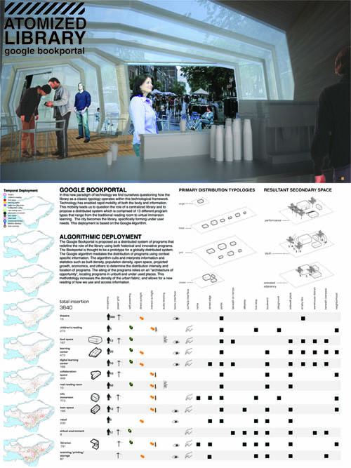
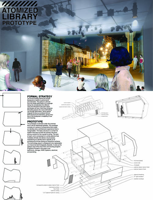
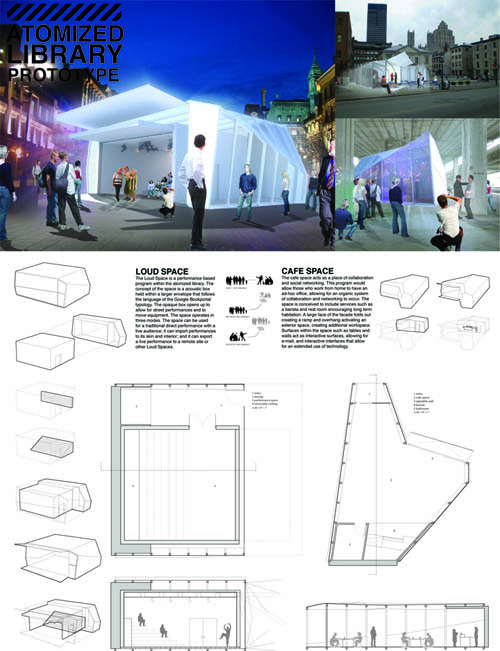
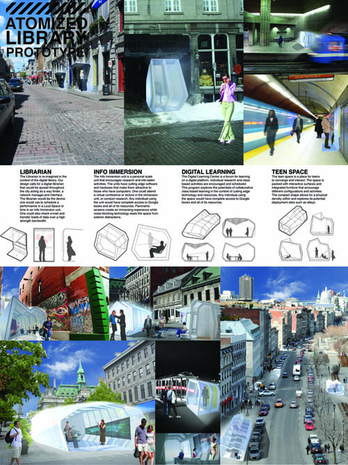
[Image: The "Atomized Library" by Duncan Young and Brett Walters].
For a recent studio at the California College of the Arts (CCA) in San Francisco, taught by Douglas Burnham of envelope A+D, students Duncan Young and Brett Walters produced what they call "The Atomized Library." It was produced as part of an overall studio exploring the space of the public library in an age of rapidly changing information storage.
[Image: The "Atomized Library" by Duncan Young and Brett Walters].
The basic idea was to scatter smaller information spaces throughout the city: buildings, kiosks, cafes, computer labs, public-access WiFi envelopes, media production centers, "teen spaces," public meeting rooms, and more. Importantly, though, the entire point of Young's investigation was to ask what libraries might look like if information was no longer accessed through books.
[Image: The "Atomized Library" by Duncan Young and Brett Walters].
"This methodology," Young and Walters write, "increases the density of the urban fabric, and allows for a new reading of how we use and access information." His units would be particularly well-suited, he suggests, for "unbuilt and under-used" urban sites.
[Image: The "Atomized Library" by Duncan Young and Brett Walters].
Think of it as a network of partially prefab, rapidly deployable, plug-in, book-less micro-libraries, with potential for global distribution. EasyLibrary, perhaps.
In fact, it raises an interesting question: when it comes to public libraries, whether we're referring to New York City or Ciudade del Este, what is the architectural equivalent of One Laptop Per Child? Is the future of the community library a modular shed, or has an entire building type been made obsolete by handheld devices?
Larger versions of these images are available on Flickr.
In a fantastic interview published last year by the Wall Street Journal, novelist Cormac McCarthy—quipping off-hand that "anything that doesn't take years of your life and drive you to suicide hardly seems worth doing"—reflects on what might or might not have caused the world-ending catastrophe that frames his recent book The Road.
The Road, of course, takes place in a relentlessly grey world, populated only by a father and his son. The anemic duo walks slowly south toward an unidentified coast over mountains and plains, through valleys and dead forests; everything is burned, molten, or obliterated. The father is coughing blood. They meet cannibals and the insane, and they stray into abandoned houses less uninhabited than they seem.
The only glimpse we're given of what violently ends the known order of things is this brief scene; I have left McCarthy's original spelling and punctuation intact:
The clocks stopped at 1:17. A long shear of light and then a series of low concussions. He got up and went to the window. What is it? she said. He didnt answer. He went into the bathroom and threw the lightswitch but the power was already gone. A dull rose glow in the windowglass. He dropped to one knee and raised the lever to stop the tub and the turned on both taps as far as they would go. She was standing in the doorway in her nightwear, clutching the jamb, cradling her belly in one hand. What is it? she said. What is happening? I dont know. Why are you taking a bath? I'm not.
After this, the landscape outside—everywhere—is described as "scabbed" and "cauterized," heavily covered in ash. McCarthy memorably writes: "They sat at the window and ate in their robes by candlelight a midnight supper and watched distant cities burn."
Later in his interview with the Wall Street Journal, McCarthy jokes that he and his brother once "talked about if there was a small percentage of the human population left [after a disaster], what would they do? They'd probably divide up into little tribes," he and his brother decided, "and when everything's gone, the only thing left to eat is each other. We know that's true historically."
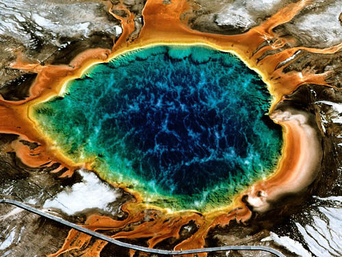
In any case, McCarthy's end-times scenario sounds, to me, remarkably like nuclear war, but in his interview McCarthy entertains, even if only casually, that it could also have been the caldera beneath Yellowstone National Park finally exploding. McCarthy:
A lot of people ask me [what caused The Road's apocalypse]. I don't have an opinion. At the Santa Fe Institute I'm with scientists of all disciplines, and some of them in geology said it looked like a meteor to them. But it could be anything—volcanic activity or it could be nuclear war. It is not really important. The whole thing now is, what do you do? The last time the caldera in Yellowstone blew, the entire North American continent was under about a foot of ash. People who've gone diving in Yellowstone Lake say that there is a bulge in the floor that is now about 100 feet high and the whole thing is just sort of pulsing. From different people you get different answers, but it could go in another three to four thousand years or it could go on Thursday. No one knows.
It was thus amazingly interesting to read that no less than 1,799 earthquakes have occurred beneath Yellowstone since January 17, 2010—a so-called earthquake swarm.
As of yesterday, however, the USGS reports that the current swarm has "slowed considerably." Indeed, we read, while "the current number of earthquakes per day is well above average at Yellowstone... nevertheless, swarms are common... with 100s to 1000s of events, some of which can reach magnitudes greater than 4.0." In other words, it is always and already a landscape prey to internal lurching deformations and displacements, as if fabricated in a fever dream by Lebbeus Woods, torqued and aterrestrially tuned to some strange counter-timescale.
Swarms like this are, structurally speaking, quite common; this is a landscape always on the move—though it doesn't necessarily travel far: "The crust beneath Yellowstone is highly fractured already," a scientist told the New York Times, "so we’re getting stress release in these earthquakes—a displacement of millimeters."
Still, when "the park’s strange and volatile geology," with its thrumming subterranean supervolcano that is "bigger, much bigger, than scientists had previously thought," kicked back into trembling motion, McCarthy's "bulge in the floor that is now about 100 feet high and... just sort of pulsing," a topographical sign of the apocalypse, instantly came to mind.
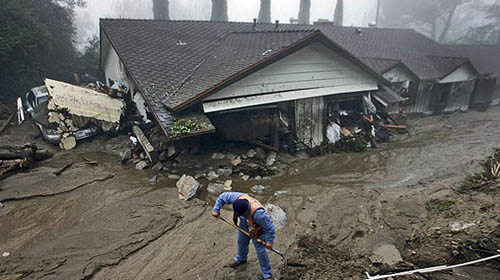
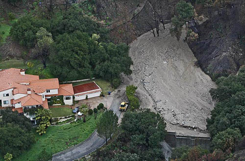
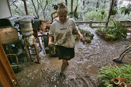
[Image: Mudslides strike Los Angeles; photo by Gary Friedman for the L.A. Times].
In his short novel Man in the Holocene, author Max Frisch describes the psychological implications of living in the presence of possible Alpine landslides. The idea that the very earth beneath your feet might someday start to avalanche takes on existential overtones.
"Nobody in the village," Frisch writes, for instance, "thinks that the day, or perhaps night, will come when the whole mountain could begin to slide, burying the village for all time." He then supplies us with the image of a "laborer who has been working all his life on supporting walls and does not believe the whole mountain could ever begin to slide"; for someone such as that, a landslide's accompanying loss of foundation is simply too extraordinary to think about.
Somewhere in the hills, though, Frisch suggests, is a hidden logic: it both explains and demonstrates how thousands of tons of rocks and the spaces between them can unlock, breaking open into discrete geometries to tumble toward the valleys below, perhaps bringing houses—whole cities—down with them.
And it can all start with a minor act: a small crack, perhaps a rainstorm, perhaps just the weight of one man hiking alone. "That is the way landslides begin, cracks appearing noiselessly, not widening, or hardly at all, for weeks on end, until suddenly, when one is least expecting it, the whole slope below the crack begins to slide, carrying even forests and all else that is not firm rock down with it," Frisch writes.
Indeed, "One must be prepared for everything."
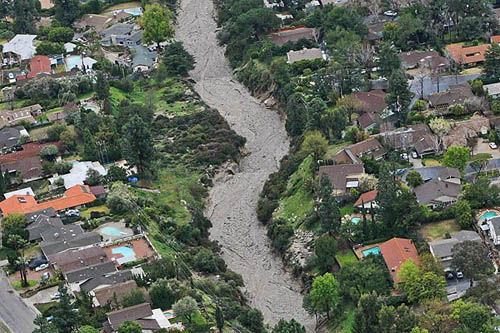
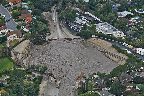
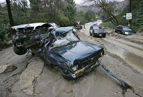
[Images: Beneath the pavement, liquid terrain. All photos by Anne Cusack for the L.A. Times].
A few months ago, meanwhile, I bookmarked a short article in the L.A. Times. Published after massive wildfires had burned through the hills around the city, denuding them of all vegetation and thus destabilizing the rock and soil, the article reported on a number of city residents in the outlying hilltop communities who had begun to eye the slopes around them with alarm. It was as if the earth itself had been weaponized: every hill, scarred by fire now and insecure for void of plantlife, was a mudslide waiting to happen.
To protect against this cascading eventuality, a new municipal landscape architecture thus emerged: mazes of concrete barriers and walls of sandbags showed up to redivide the streets. Circulation through the neighborhood would be entirely redefined, and a massive landscape of waiting would be installed: a space patient for all the material locked inside those hills to arrive.
Officials have said the concrete barriers [they soon installed] will stay in place for three to four years because the hillsides are completely barren in the wake of the Station fire, which charred more than 160,000 acres. It was the worst wildfire in L.A. County's history. Many measures had been put in place, including the clearing of debris basins, the notification of residents in high-risk areas, the distribution of sandbags and the laying of several thousand feet of K-rails.
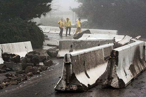
These spatial precautions were put to heavy use last week when the hills disgorged themselves, liquifying, going mobile, and flowing through, past, and over the neighborhood houses.
"The mudflow twisted garage doors into dented accordions," we read, and it "disintegrated walls of sandbags and knocked over 4,000-pound concrete barriers that lined the road to divert water away from homes. About 25 vehicles were damaged, flowing down the street and smashing against walls, trees and one another." In one case, "a white single-story home appeared submerged in several feet of dirt, looking as if a giant child had dropped the house in a sand pit."
Another man, woken up in his Snover Canyon house in the middle of the night, looked outside to see "muddy water carrying boulders the size of bowling balls... through the 4-foot-high barricade of sandbags, a plywood wall and a chain-link fence. A sheet of mud nearly a half-foot deep and 16 feet wide cascaded across the backyard."
He ran to the bathroom window. He had expected this. It was the weak point of his defense. There at the corner of the yard, a geyser of water crashed into the remains of the wall and shot into the air. He had to get his family out. He didn’t know what else might be coming down that mountain.
The terrestrial uncertainty of that final sentence is astonishing.
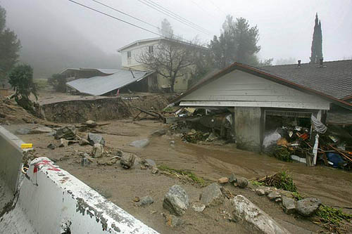
Once the mudslides abated in one district, "nine homes in the foothill area suffered enough damage to be red-tagged, which means they’re partially collapsed and uninhabitable. With crumbling walls, sunken roofs, shattered windows and mud-filled living rooms, the structures are in a precarious position," themselves now more like residual appendages of the debris flow than freestanding architectural units.
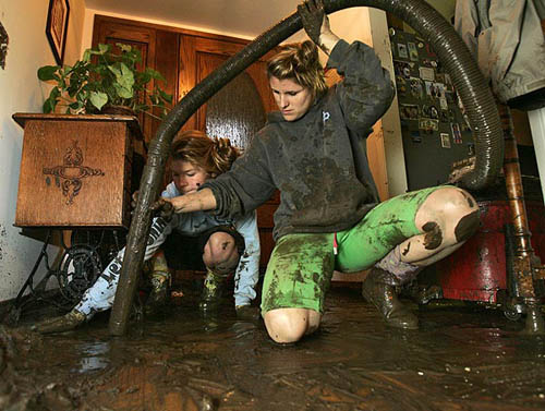
However, perhaps the best article ever written about mudslides in Los Angeles was produced nearly 30 years ago by John McPhee. Called "Los Angeles Against the Mountains," it was originally published in The New Yorker but was later collected in McPhee's genuinely excellent and very highly recommended book The Control of Nature.
Among many other things, McPhee devotes several paragraphs to a description of the DIY architectural tweaks that have arisen in response to these landscapes-gone-mobile. "At least one family," he writes, for instance, "has experienced so many debris flows coming through their back yard that they long ago installed overhead doors in the rear end of their built-in garage. To guide the flows, they put deflection walls in their back yard. Now when the boulders come they open both ends of their garage, and the debris goes through to the street."
Not only has this image stuck with me for years now, ever since I first read McPhee's book, but it has also been impossible for me to avoid thinking about when looking at the photographs you see here, particularly those taken on the mud-slicked streets themselves by Irfan Khan. But the very idea that one could deliberately open a causeway for the natural world to flow, with awe-inspiring violence, through one's own personal space—that you could actually build a kind of sacrifice zone within your own house for forces otherwise well beyond spatial control—is, at the very least, an extraordinary metaphor for living with the natural world.
This minor architecture—of repurposed overhead doors, emergency ditching, concrete crib structures, deflection walls, and more—brings the ever-present possibility of geologic collapse into world of design.
After all, how do you build on an earth that keeps disappearing?
[Images: Photos by Irfan Khan for the L.A. Times].
Returning to Frisch's book, there is a fantastic, if brief, image of sound being put to use to stimulate minor avalanches, perhaps as a way to help avoid the Big One later on. "Men blow three times on a little horn and wave a red flag," Frisch writes, as if describing a fairy tale of precisely administered sonic land-disassembly, "and shortly afterward the bits come rattling down, pebbles and gravel from the Ice Age."
I mention this out of the possibility that perhaps Los Angeles city officials should not be responding to the ever-present threat of landslides on the urban perimeter with hardened architectural defenses but with something more like preemptive techniques: why wait for the hills to come to you, in other words (see this diagram of how debris basins work), when you could simply bring them down on your own time and schedule, in rock-by-rock increments, pulling rivers of solid geology out from their halo'd terraces above the city? Could micro-landslides somehow keep apocalyptic avalanches at bay?
Or, more realistically, does L.A. need to ditch the bulky mazes of concrete switching walls and go for a massive replanting effort, instead? Like Beijing's Great Green Wall against the coming desert, L.A. needs to plant a wall of minor roots against the instability of its mountains.
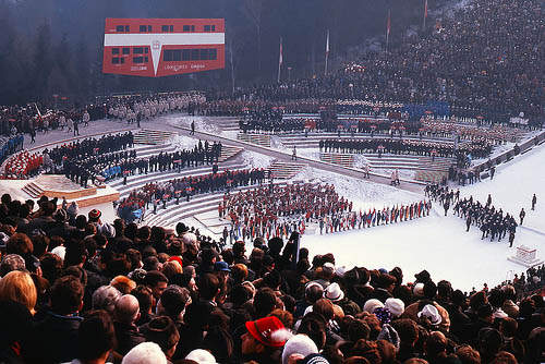
[Image: The opening ceremony of the 1964 Innsbruck Winter Olympics; photographer unknown].
A comment from Alexander Trevi on a recent post pointed our attention to the final paragraph of an article by the Associated Press: "According to the International Olympic Committee," we read there as part of an overall discussion of the forthcoming Vancouver Olympics and that city's unseasonal condition of snowlessness, "the 1964 Innsbruck Games also faced a lack of snow. The Austrian army rushed to the rescue," however, "carving out 20,000 blocks of ice from the mountainside and transporting it to the luge and bobsled tracks. They also carried 1.4 million cubic feet of snow to the Alpine ski slopes."
This landscape-on-the-move arrived just in time to format the local terrain for winter sports purposes, temporarily repurposing an assembly line of athletic tracks and military equipment in the process.
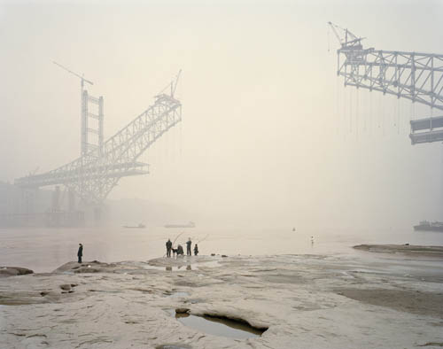
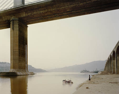
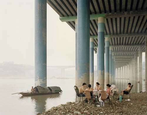
The Yangtze River, which forms the premise to this body of work, is the main artery that flows 4100 miles (6500km) across china, traveling from its furthest westerly point in Qinghai Province to Shanghai in the east. The river is embedded in the consciousness of the Chinese, even for those who live thousands of miles from the river. It plays a significant role in both the spiritual and physical life of the people.
Kander "photographed the landscape and people along its banks from mouth to source"—a daunting task, for, as Kander points out, "more people live along its banks than live in the USA, one in every eighteen people on the planet."
Part of Kander's visual goal was "showing humans dwarfed by their surroundings. Common man," the photographer adds, "has little say in China’s progression and this smallness of the individual is alluded to in the work."
The images featured in this post have the feel of a film set—more cinematography than photography—as if Kander has unknowingly captured a mise-en-scène, some wrongly cut dramatic moment, unfolding on the river banks.
Actors, perhaps unsure of their larger narrative role, seem overwhelmed by their infrastructural surroundings.
The stage set-design theories of Edward Gordon Craig come to mind. Craig was an early 20th-century stage set designer (and son of an architect), whose "architectonic scenery," according to M. Christine Boyer, foregrounded architectural backdrops so strongly that his props ultimately became the only on-stage action an audience was meant to watch.
Craig "proposed that a stage in which walls and shapes rose up and opened out, unfolded or retreated in endless motion could become a performance without any actors," Boyer writes. "The stage thus became a device to receive the play of light rhythmically, creating an endless variety of mobile cubic shapes and varying spaces. Deep wells, stairs, open spaces, platforms, or partitions created a stage of complete mobility, which Craig believed appealed to the imagination." It is a stage devoid of actors, in other words, just large pieces of equipment moving about according to the rules of their own choreography.
What happens, then, if this depopulated dramaturgy becomes blown-up to the scale of national infrastructure?
In one sense, this perfectly empty landscape into which humans try vainly—and at great emotional cost—to situate themselves is the hallmark of J.G. Ballard. We might even specifically ask, looking at Kander's photos: when will a Yangtze River-based rewriting of Ballard's Concrete Island come along, exploring these spatial questions?
Concrete Island, of course, is Ballard's 1974 novel about a London motorist—as it happens, an architect—who is stranded on his way home by a car accident. Freeing himself from his ruined vehicle at sundown, he finds himself trapped beneath the yawning arches of the motorway, stranded in a peripheral world of drainage culverts, ascent ramps, sliproads, and storm tunnels, a kind of urban blindspot (read Mike Bonsall's awesome forensic archaeology of London's Westway, a spatial interrogation of the built environment in order to discover where Ballard's novel was meant to be set).
With no rescue in sight, Ballard's architect is left to fend for himself, surrounded by gigantic pieces of urban infrastructure whose purpose now seems oddly counter-human; he is "alone in this forgotten world whose furthest shores were defined only by the roar of automobile engines... an alien planet abandoned by its inhabitants, a race of motorway builders who had long since vanished but had bequeathed to him this concrete wilderness."
I'm left wondering: who is the J.G. Ballard of contemporary China? Nadav Kander's photographs—many more of which can be seen at the Prix Pictet site—are an enticing glimpse of what a Ballardian sensibility might create there.
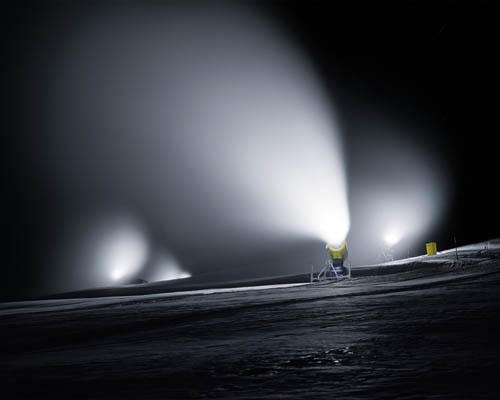
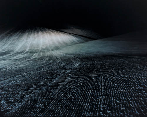
I was reminded, via an old post on Pruned, of an amazing series of photographs by Jules Spinatsch called Snow Management; Snow Management was deservedly short-listed in 2008 for the Prix Prictet.
With those images, Spinatsch documents the infrastructure of snow control—and outright terrain manufacture—at an Alpine resort, including the labyrinths of retaining fences and the individual pieces of equipment that make snow creation and large-scale, though ephemeral, landscape-sculpting possible.
In a way, these scenes are like a big-budget variation on Sergio López-Piñeiro's idea, discovered via Mammoth, of a snow park or whitesward. López-Piñeiro's own photographic documentation of urban plowing practices—that is, the deliberate reshaping of snow piles into an ephemeral, new, seasonal topography—is an attempt, he writes, "to show how standard plowing techniques can become creative tools for generating winter landscapes." López-Piñeiro continues:
The white parks that I envision could be easily constructed: plowing master plans would carefully locate the snow mounds, and the resulting designs would artistically exploit the spatial conditions defined by these usually overlooked piles of snow.
In winter, an artfully shaped snow landscape could become a “whitesward”—underscoring the now obscured potential for plowing to positively transform public space. Such a white landscape could be considered a “snow observation ground” to encourage people to appreciate the snow and its accumulation, and to dispel the negative impressions and experiences that our combative approach has produced.
Ski resorts, with their huge array of technical devices and machinic subfamilies all geared toward—indeed, specifically invented for—the purpose of creating new landscapes below the thermal boundary at which their engineered shapes will liquify, become extraordinary experiments in terrain-generation on a massive scale. They are a kind of igneous hydrology: the controlled freezing of matter into artificial forms.
More images from Jules Spinatsch's spectacular series are available on his website, and the Snow Management series itself can also be downloaded as a 3.2MB PDF.
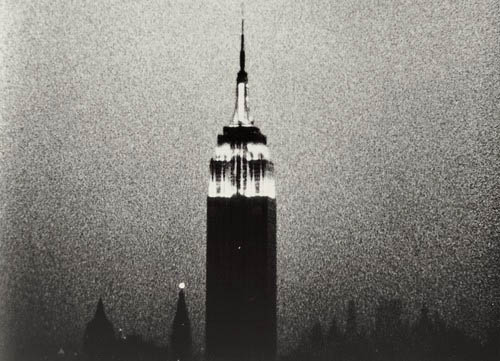
Tomorrow at noon here in New York City, a musical event that I would love to attend kicks off: 8 solid hours of sound, providing a live accompaniment for Andy Warhol's Empire—a film notorious for its one, unchanging shot of the Empire State Building.
Hanno Leichtmann, Andrew Pekler, and, most exciting at least for me, Jan Jelinek—who, bizarrely, I once introduced myself to at WMF in Berlin—will be providing the music.
The Museum of Modern Art describes Empire as follows:
Empire consists of a single stationary shot of the Empire State Building filmed from 8:06 p.m. to 2:42 a.m., July 25–26, 1964. The eight-hour, five-minute film, which is typically shown in a theater, lacks a traditional narrative or characters. The passage from daylight to darkness becomes the film’s narrative, while the protagonist is the iconic building that was (and is again) the tallest in New York City. Warhol lengthened Empire's running time by projecting the film at a speed of sixteen frames per second, slower than its shooting speed of twenty-four frames per second, thus making the progression to darkness almost imperceptible. Non-events such as a blinking light at the top of a neighboring building mark the passage of time. According to Warhol, the point of this film—perhaps his most famous and influential cinematic work—is to "see time go by."
In fact, after a long day spent touring the involuted subterranea of Kentucky's Mammoth Cave back in 2001, Nicola Twilley and I drove home listening to Vladislav Delay's Entain, our car creaking over the hollow roof of an earth below us, its caverns hidden beneath overgrown bedrock, sinkholes perhaps waiting on either side of the highway, heading northwest over collapse-prone mineral logics toward Chicago.
Volume magazine is hosting a conference this coming May about what they call "the Architecture of Peace." Part of this will be assembling "an inventory of inspiring projects for (post-)conflict territories"—and they're hoping that you will get involved.
Are you an architect, designer, urbanist or community leader? Have you developed a project that aids to channel social relationships in a more peaceful way? Then get in touch with Volume. Send a short description to info@archis.org with the subject "AoP projects call," and we will endeavour to include it in our conference material, providing a unique overview of projects of this kind.
From post-military landscape remediation projects to transborder community exchange programs, from conflict gardens to films, from anti-gang territorial initiatives to bunker recycling services, from museums of slave history to a cartography of divided cities, I would imagine there is a huge range of ideas and examples out there to explore.
For his master's thesis, produced last year under the direction of Timo Arnall, Matt Jones, Jack Schulze, Lennart Andersson, and Mikael Wiberg, designer Matt Cottam directed this short video about a technique for growing electrical circuitry inside the trunks of living trees. Just inject the right trace metals, Cottam's mad scientist narrator explains, do some more techno-magic, and simply let the wood grow...
If only it were true. But the day will come, my t-shirt will read, when all the trees around us are computers.
2) While researching blackouts for a seminar I am teaching this winter at Pratt, I stumbled on a strange anecdote from The New York Times, published back in 1986, about a plant physiologist at the Brooklyn Botanic Garden who was seeking a way to end the risk of "trees crashing down on power lines" (a major source of power interruptions).
"One of the things we're looking at," the scientist explained, "is something that will directly retard the growth of trees"—that is, chemicals "that interfere with the basic growth hormones." He was trying to develop, he adds, "a mild chemical" that would deliberately slow tree growth, "and instead of spraying we're injecting [it] directly into the tree."
Who knows where that research has now led them, twenty-four years later, but I'd suggest someone might want to mail them a copy of The Death of Grass. ASAP.
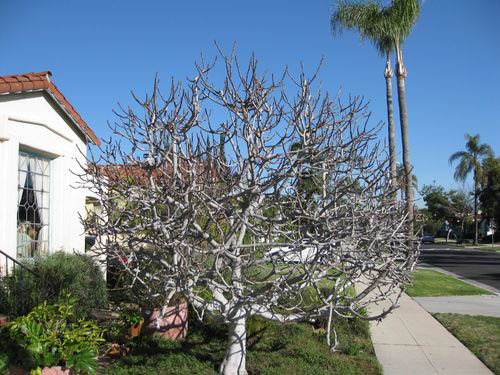
[Image: A fig tree grows in Los Angeles; photo by Pieter Severynen].
3) While going back through old bookmarks this morning, I rediscovered Tree of the Week, a series of articles run by the Los Angeles Times. The overall project could be described as a botanical cartography of the city: a catalog of Angeleno trees.
This week's tree is the "highly productive fig"; last week's was the Blackwood Acacia. With regard to the latter tree, Pieter Severynen, the series author, writes: "Given its negative properties it should be clear that a description of this tree, or for that matter any tree of the week, does not imply an endorsement to plant. Instead it is offered as a means to learn more about the existing trees that make up the fascinating urban forest surrounding us in the Southland."
The "fascinating urban forest surrounding us in the Southland" includes the Weltwitschia, the "picturesque Aleppo pine," and, of course, among many others, the apple, a tree genetically sculpted over the millennia through "hundreds of accidental and deliberate cross-hybridizations" around the world, Severynen writes.
Anyone interested in exploring the urban forests of Los Angeles would do well to check out the fruit maps of Fallen Fruit, who have discovered in the seemingly random dispersal of fruit trees around Silver Lake the remnant outlines of long-forgotten orchards; but if your curiosity goes further afield than L.A., the absolutely fantastic book Wildwood, by the late Roger Deakin, has truly unforgettable descriptions of walnut harvesting in Kazakhstan, old-growth Eastern European forests filled with war ruins and shrapnel, and Deakin's own backyard in England. It is often astonishingly beautiful—and it also Deakin's last major work.
Perhaps cities like Montreal and Stockholm—even L.A., watching auroras torque and fold over the black waters of the Pacific—should simply hire small fleets of barium-carrying orbital vehicles to keep the skies interesting all winter long.
BLDGBLOG ("building blog") is written by Geoff Manaugh. The opinions expressed here are my own; they do not reflect the views of my friends, editors, employers, publishers, or colleagues, with whom this blog is not affiliated. More.

 [Image: From Elevated Descent: The Helipads of Downtown Los Angeles, Center for Land Use Interpretation].
 [Image:
 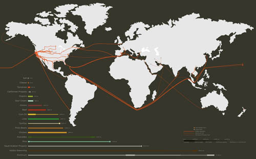 Like a culinary version of
 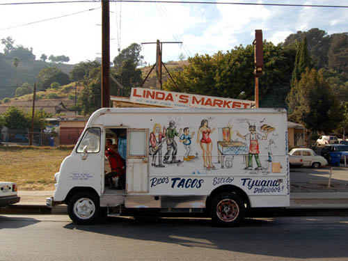 [Image: "There are two basic types of taco trucks," we read; "the first and most common is the transient truck which is a truck that stops at approximately 20 different locations at 20-minute intervals during an 8-hour shift, typically beginning at 6am and ending at 2pm. The second type is the semi-permanent truck, which is a truck that has found a location that has a density of clientele to sustain it for an extended period of the day, creating a nearly fixed presence in a particular community." From
  [Image: From