Explaining their approach, the architects write that "the Guggenheim has become, in a sense, a victim of its own success due to an over-saturation of human movement in a singular space. Our proposal aims to accomplish the seemingly incompatible: to restore a museum environment conducive to experiencing art and to maximize and heighten other experiences brought about by the iconic status of the museum itself."
The specific strategy here is "to trap, i.e., to force a pause. This programmatic component was not considered by Wright, who envisioned a space defined by tireless motion."
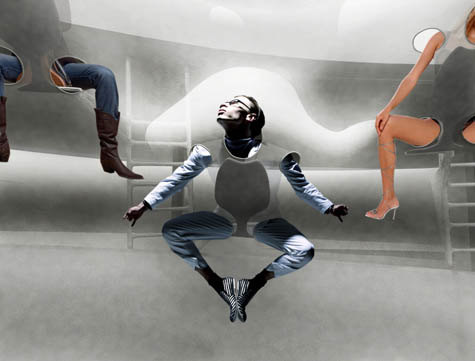
The resulting project is a gigantic membrane stretched throughout the interior, supplying "180 saddle-like seats along the entire ramp for pausing and viewing the rotunda."
These seats protrude into the void with access ladders arranged in between the floor and the ceiling over the guardrails. Each of the 90 access ladders holds two cantilevering seats, which are angled gradually as they ascend to allow a view of the central area at ground level that functions almost like a stage—as though the rotunda were a new hybrid of opera house and arena. The 180 protrusions over the void are draped with a single, soft and translucent membrane that functions as a safety net.
The architects continue, writing that "the pop-out pods, each approximately 60 cm deep, contain seats," and "each pod has five openings for the head and limbs, which make the membrane"—and I love this metaphor—"much like a garment that can be worn collectively by 180 people."
Imagining a piece of clothing so huge you mistake for a building is an awesome change in both scale and context; you would go inside by putting the building on, slipping in one arm at a time.
Of course, this also raises the possibility of tailoring clothing specifically to function only within certain very specific architectural structures: nylon tights that only make sense to wear when seated in one of Cho's "pop-out pods," or sweaters that allow you to experience the spatial extravagance of luxury elevators at a new W Hotel in London. You and some friends zip yourselves up into the wall, forming a new private room that would otherwise not be there.
But Cho saves the best analogy for last: once the overflowing crowds of art-drunk tourists come to fill the "pop-out pods," it "as if they were performing as a part of a living Baroque ceiling sculpture."
I had the pleasure of seeing Cho present this project in person at a lecture he gave back in October at Columbia University; this was the project with which he kicked-off the evening, and it set a fantastically giddy tone for the rest of Mass Studies' work.
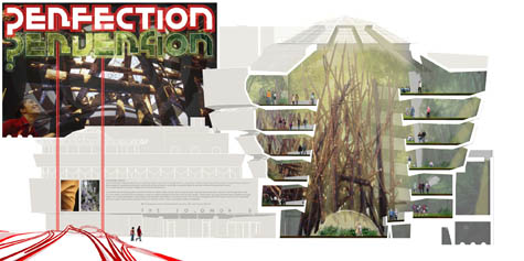
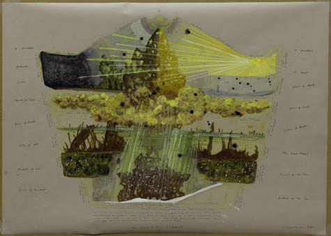
For a forthcoming exhibition called Contemplating the Void, New York's Guggenheim Museum "invited more than two hundred artists, architects, and designers to imagine their dream interventions in the space."
In this exhibition of ideal projects, certain themes emerge, including the return to nature in its primordial state, the desire to climb the building, the interplay of light and space, the interest in diaphanous effects as a counterpoint to the concrete structure, and the impact of sound on the environment.
Many of the images provide great eye-candy, as you'll see, and I've included the best of those here (with my personal favorite coming up in the next post).
The interior is taken over by coastal rain forests; there are mystical arabesques of colored music wrapping upward in spatially impossible curls through the museum's disappeared roof; there are trampolines and climbing nets strung from wall to wall above the lobby.
The Museum of Simulated Suicides, you could call it, where go to experience what it might be like to throw themselves into the void. You get a certificate of survival at the end.
There are photo-collages and sectional diagrams of internally returning ecosystems.
[Images: (top) Morris in Guggenheim by M/M (2009), (center) Perfection_Perversion by West 8 (2009), and (bottom) The House of GI–A Proposal by Matthew Ritchie (2009)].
There are vast white balloons with visible structures trapped inside them rising out into New York's winter skies—
[Image: State Fair Guggenheim by MAD Architects (2009)].
—as well as storms of red dust falling downward in a kind of gravitational pollution of the lobby.
Perhaps predictably, though, I might say an even better intervention into the Guggenheim's space is not a series of objects or architectural alterations at all, but an event—by which I'm specifically referring to one of 2009's most talked-about spatial moments, at least in architectural circles, when we see that very same museum annihilated in a hail of bullets in the film The International.
[Image: A poster for The International featuring the Guggenheim Museum (2009)].
For all these calls for ideas and architectural design competitions, what if Hollywood set designers and location scouts are doing a more provocative job in non-preciously reimagining the inherited icons of the global built environment than 21st century architects?
These and many other images will be on display when the exhibition, Contemplating the Void, opens February 12, 2010.
Temporary lakes have sprung up all over Manhattan again this week, sometimes more than twenty feet wide and a foot deep, spanning curbs and pooling in gutters, the aquatic remains of last week's rain and snowmelt.
This surprise limnology—often demanding new, indirect lines of approach from one side of the street to the next—reminded me of David Gissen's recent, recommended book Subnature, which includes an entire chapter on urban puddles.
"Although we often think of puddles as inconsequential," Gissen writes, "they appear in architectural history in prominent ways—in drawings of ruins, photographs of decaying buildings, and experimental designs that attempt to use water in provocative ways." Now, however, "these stagnant pools of water, once signifying society's vulnerabilities, appear to have disappeared in much contemporary work"; indeed, he adds, contemporary architects have seemingly always "viewed stagnant water with suspicion." There is good medical reason for this suspicion, of course; indeed, the Centers for Disease Control advised last year that "neglected swimming pools"—i.e. stagnant bodies of water—are fast becoming vectors for mosquito-borne disease.
The CDC specifically cites "the adjustable rate mortgage and associated housing crises" as unexpected disease incubators: "Associated with home abandonment was the expanding number of neglected swimming pools, jacuzzis (hot tubs), and ornamental ponds. As chemicals deteriorated, invasive algal blooms created green swimming pools that were exploited rapidly by urban mosquitoes, thereby establishing a myriad of larval habitats within suburban neighborhoods," they wrote.
In any case, Gissen describes "visions of the undrainable city" as a kind of sickly counterpart to the modern, infrastructurally managed, rational metropolis, pointing out that "the waters inundating the modern city rained from above and surged from below." These overload our modern streets and sewers, bringing even 21st-century cities closer to the flooded Roman basements of Piranesi than to the hygienic visions of Le Corbusier, Gissen suggests. I'm reminded here of a disconcerting remark made by Alan Weisman in The World Without Us that the subways of New York City would be irreparably flooded within only 36 hours if the city's underground pumps ceased to function.
While reading Gissen's chapter on puddles, however, one of the first things that came to mind is that someone should produce a puddle map of New York—an urban atlas of temporary flooding. Set your parameters—puddles one foot deep by thirty-feet wide, say, or, more accurately, a volumetric guideline (at least one hundred square-feet of water or no less than 120 gallons)—and bring these fleeting aqueous forms into the geographic consciousness of the city.
From one rainy season to the next, an accelerated paleolimnology of New York thus comes into being; the Lake Lahontans and Lake Agassizs of the five boroughs are given their cartographic due. Here a tiny lake once stood, historical plaques could read, bringing to mind a liquid version of Taylor Square, the famed "smallest park" in Cambridge, Massachusetts.
What monstrous puddles have existed in your neighborhood, and how have the urban circumstances of their existence changed over time? Did curb-cuts or new drains eliminate these hydro-geographies—or even make them worse? And whose lives have been affected by these unmapped bodies of water, whether through hydroplaning, sidewalk splashes, or even an expensive pair of ruined shoes?
Whole personal histories of human contact with puddles, and the effects such exposure might have, could be produced or recorded. This is extraordinary: we live beside temporary lakes and inland seas in cities all over the planet, yet these landmarks never make it onto our maps.
Writing about the human experience of night before electricity, A. Roger Ekirch points out that almost all internal architectural environments took on a murky, otherworldy lack of detail after the sun had gone down. It was not uncommon to find oneself in a room that was both spatially unfamiliar and even possibly dangerous; to avoid damage to physical property as well as personal injury to oneself, several easy techniques of architectural self-location would be required.
Citing Jean-Jacques Rousseau's book Émile, Ekirch suggests that echolocation was one of the best methods: a portable, sonic tool for finding your way through unfamiliar towns or buildings. And it could all be as simple as clapping. From Émile: "You will perceive by the resonance of the place whether the area is large or small, whether you are in the middle or in a corner." You could then move about that space with a knowledge, however vague, of your surroundings, avoiding the painful edge where space gives way to object. And if you get lost, you can simply clap again.
Ekirch goes on to say, however, that "a number of ingenious techniques" were developed in a pre-electrified world for finding one's way through darkness (even across natural landscapes by night). These techniques were "no doubt passed from one generation to another," he adds, implying that there might yet be assembled a catalog of vernacular techniques for navigating darkness. It would be a fascinating thing to read.
Some of these techniques, beyond Rousseau and his clapping hands, were material; they included small signs and markers such as "a handmade notch in the wood railing leading to the second floor," allowing you to calculate how many steps lay ahead, as well as backing all furniture up against the walls at night to open clear paths of movement through the household.
Entire, community-wide children's games were also devised so that everyone growing up in a village could become intimately familiar with the local landscape.
Games like "Round and Round the Village," popular in much of England, familiarized children at an early age to their physical surroundings, as did fishing, collecting herbs, and running errands. Schooled by adults in night's perils, children learned to negotiate the landscapes "as a rabbit knows his burrow"—careful after dark to skirt ponds, wells, and other hazardous terrain. In towns and cities, shop signs, doorways, and back alleys afforded fixed landmarks for neighborhood youths.
Incredibly, Ekirch points out, "Only during the winter, in the event of a heavy snowfall, could surroundings lose their familiarity, despite the advantage to travels of a lighter, more visible landscape." The mnemonic presence of well-known community landmarks has been replaced by what mammoth calls a "whitesward."
But this idea, so incredibly basic, that children's games could actually function as pedagogic tools—immersive geographic lessons—so that kids might learn how to prepare for the coming night, is an amazing one, and I have to wonder what games today might serve a similar function. Earthquake-preparedness drills?
In any case, we return to Rousseau. We see him advancing, now, heading forward into unknown architecture, dark space enveloping him on all sides, the walls fading into obscurity, black, leg-breaking stairwells threatening in the distance, unsure of where he stands, entirely alone in this shadow... until we hear a series of claps. And then another. Then one more.
And the philosopher, echoing himself, finding comfort and location based on objects he can't see, soon works his way out of the labyrinth.
[Images: Two diagrams stitched together showing acoustics of bat echolocation at Carlsbad Caverns].
For those of you with audio-spatial interests, Word of Mouth on New Hampshire Public Radio ran a twenty-minute conversation between myself and Jace Clayton yesterday called "Music for Landscapes."
We talk about urban acoustics, the sounds of flooded cities, DJing in ruined border towns on the divided island of Cyprus, some thoughts on echolocation by way of Jean-Jacques Rousseau, and more. Enjoy!
Photographer Richard Mosse, originally from Ireland, is a graduate of the Yale MFA program in photography, as well as a recipient of a Leonore Annenberg Fellowship in the Performing and Visual Arts. This Fellowship has funded Mosse's ongoing and extraordinary series of travels around the world.
Readers of BLDGBLOG will recognize his work from its previous appearances here—whether that's the air disaster simulations of a year or two back or the full interview with Mosse about his, until then, unpublished photographs of Saddam Hussein's palaces.
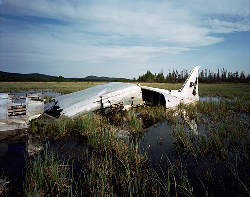
Having worked together all Autumn as part of the quarantine studio here in New York, Mosse and I coordinated another interview, via email, about his most recent solo exhibition. That show, called The Fall, features photographs of extremely remote airplane crash sites, with often partially dismantled or disintegrated wrecks disappearing into an uninhabited landscape; Mosse compares these structures to the Arctic shipwrecks and ruined forest abbeys of painter Caspar David Friedrich. The images will be on display for only two more days—closing Wednesday, 23 December 2009—at New York's Jack Shainman Gallery.
In the following interview, Richard Mosse discusses the visual representation of catastrophe; conceptual links between terrorism, advertising, and photography; the 2006 disappearance of pilot Steve Fossett; surveillance subcultures along the U.S./Mexico border; the short fiction of J.G. Ballard; and Werner Herzog's film Fata Morgana.
• • •
BLDGBLOG: I'd like to start off with a fairly practical question: how do you actually locate these plane wrecks, many of which received no media coverage at all?
Mosse: These photos are the result of months of online research, skimming forums, YouTube videos, Google Earth, Flickr, emailing wreck chasers, and cold-calling bush pilots. I'd even surf the web for jpegs of plane wrecks, then bring this information into Google Earth in the hopes of finding tiny silhouettes of downed planes. I was searching for accidents so disintegrated and remote to civilization that they only really exist in the virtual imagination of transient and anonymous online communities. Others had become landmarks, a destination for the intrepid to come and leave their trace.
Like 19th-century survey photography, it became a process of charting the unknown—but it's also a kind of picaresque quest narrative. I think the work has echoes of the poète maudit, the immoral artist figure who will go to any extreme, transgressing any boundaries in pursuit of the ultimate aesthetic experience.
BLDGBLOG: Abstractly speaking, was it that idea of trespassing and transgression—photographing something that terrifies so many people and that so few people actually witness or see—that drew you to this project?
Richard Mosse: I’m fascinated by contemporary art’s ability to point to the limits of experience, making visible what can't otherwise be represented. Photography, meanwhile, is supposed to be rooted in the world of things, as it carries an actual physical memory of the world at a specific time and place. Between these poles, I think photography has a unique potential to represent human suffering—which is, after all, something that cannot be represented. I cannot literally feel your pain; you cannot adequately express that pain. Pain is an essentially private affair, yet it is something experienced by all of us. Starting from these basic ideas, I'm hoping to find a better way to describe the catastrophe. By this I mean a totalizing concept of warfare, disaster, the battlefield—the things that define our era but which have become increasingly abstract, impersonalized, invisible, simulated and global.
So how is the catastrophe popularly represented? Through terrorism. Terrorism is a gesture of advertising; it’s a literary act, a form of representation, before all else. Its aim is not primarily to kill, but to capture the popular imagination through killing. It’s for this reason that I’m drawn to the air disaster: there is no finer, more succinct, more international, and more culturally loaded expression of the catastrophe than a plane crash. An airliner in vertical descent is a spectacle of modernity's complete failure. It is horrifying, but also aesthetically powerful—and it's for these reasons that terrorists covet the air disaster. I feel that photographers, who work in close proximity to advertising, can enter the terrorist’s symbolic order and violate the same taboos.
Like the catastrophe, the air disaster is virtually impossible to represent. After the Continental crash near Buffalo last year, I traveled immediately to the site. It was totally inaccessible. In only a few hours, various authorities had come together to form a kind of firewall around the event; it had become opaque with layers of jurisdiction.
BLDGBLOG: How did you manage to get near the wreckage?
Mosse: The plane had crashed into a suburban neighborhood, and state troopers were waving down the traffic about a mile or so from the site. I parked up in the woods nearby, slung my camera and tripod in a shoulder bag, and trespassed through people’s backyards in the hope of being taken for a resident. I was able to walk almost to the crash site itself, about 100 yards from the wreckage, where I stood and watched the disaster bureaucracy arrange and rearrange itself while body bags were carried out.
Unable to get any closer than that, and with no clear line of sight, I looked for some trace of the disaster violating this residential idyll and found police tape slung around trees whose branches had been broken by the crash. I set up the tripod and within about twelve seconds the veil had closed in. First came the local officers, and then the Feds. They kept me there for about an hour, ran my name and social security number, and threatened me with arrest.
I began to understand this larger project as a kind of deferral: I started to look sideways at the air disaster through older wrecks, forgotten relics in the middle of nowhere. There are layers of deferral here which attempt to access a crystallization of themes surrounding the air disaster. Control. Remoteness. Archaeology. Time. Environment. Form. Scale. Quest. The hidden. Taboo. In making these images, I'm aiming towards something aligned in spirit with Caspar David Friedrich's painting, Das Eismeer: spatial remoteness becomes temporal remoteness, and the forgotten plane wreck is swallowed by the primeval landscape.
BLDGBLOG: Friedrich's Arctic shipwreck brings to mind a pretty incredible video that you've put together, called Leviathan. It features wrecked airplanes emerging from, or being dropped into, the sea. Can you tell me more about that project?
Mosse: I met an extraordinary Dutchman out in Thailand who is known in wreck-chasing circles as the Dakota Hunter. Once an advertising director for a cigarette company, the Dakota Hunter ventures into the world's remotest places to salvage the wingtips of C-47 Dakotas, which he then ships back to the Netherlands to be sandblasted and turned into luxury tables for boardrooms and executive offices. He very generously tipped me off about a Thai-organized project sinking Dakota aircraft into the waves off Phuket. These aircraft were vintage American military bombers (and Sikorsky attack helicopters) from the Vietnam War that had been donated to the Thai Army upon America's withdrawal from Saigon. They had been flown by the Thai Air Force until they could fly no longer, and have since lain rusting in the jungle.
But the diving clubs of Phuket, struggling to re-stimulate the dive-tourism industry as well as the coral reef environment that had been virtually wiped out by the recent tsunami, came up with the idea of sinking these decommissioned aircraft onto the ocean floor.
I pulled this footage from Thailand together with a second video showing the 2009 US Airways crash in the Hudson River. In this piece, I became fascinated by themes of tourism, disaster, globalization, the military-industrial complex, and history. But most of all, I'm drawn to the aesthetic power of the air disaster, and the majesty of watching airplanes be submerged and re-emerge from water, like a kind of baptismal rite. The sea has a wide array of psychoanalytic and mythic associations which I feel produce sparks of meaning when they coincide with the airplane's modern form.
You can watch an unfinished version of the film below. This was shot and edited by Trevor Tweeten, with coloring and post-production by Jerome Thelia, and sound by Martin Clarke. Please note that this piece is not yet finished; it's just an early draft.
BLDGBLOG: You're not a pilot yourself, meanwhile, so getting to these sites must have required a tremendous amount of assistance. Can you tell me a bit more about the people who helped you visit—like the Dutchman in Thailand—and the process you had to go through to get to these places?
Mosse: I actually had to abandon one trip to see a wreck in a high mountain pass because of bear-paw prints in the snow! On my return trip, I brought a local fellow with a shotgun. I asked him whether he’d ever had an encounter with a bear, but he wouldn’t tell me, saying that he’d give me an answer after we reached the wreck and were making our way back down the mountain. Once I’d finished making the photograph and we’d started for home, I asked impatiently for an answer. He told a fabulous story of being charged by a five hundred pound grizzly who picked him up in her jaws and flung him like a ragdoll. Lucky for him, he managed to fire a shot at the bear while it was coming at him, saving his life. He showed me the wounds on his shoulder and forearm.
That trip was by all-terrain vehicle—with a few hours of heavy walking through snow—but, on other forays, I’ve hired a helicopter. I had a choice of pilots in a town in the Yukon, and decided to go with the Swiss pilot, thinking he’d be safer. But he totally failed to find the wreck and flew me to the top of a mountain range where we sallied out into the snow to frown at the horizon. I made a second attempt the same day with a different pilot, one who had lived there all his life. He took me straight to the wreck and suggested many others. Always shop local.
Another pilot dropped me into a swamp, way out in the Yukon wilderness. He left me there alone and flew off to refuel. I had to wade up to my armpits in the swampy water for hours, apprehensive that the helicopter would never return. But my fears were forgotten when I discovered that an animal, perhaps an otter or a mink, had built a nest out of reeds in the shelter of the belly of the plane wreck, and birds had propped their nests in holes in the back fin.
[Images: (top) "C-47 Beaver Creek" and (bottom) "C-47 Snag" by Richard Mosse].
BLDGBLOG: What about particularly unexpected or surreal plane wrecks?
Mosse: The tail of an old Nazi Junkers was discovered while dredging a lake in northern Finland. I suppose nobody knew what to do with it, because it was simply dumped in the car park of a supermarket, in the same sort of place that joyriders might abandon a burned out car. I like to imagine the local people driving carefully around the old Nazi tailfin, and it becoming a well-known attraction in the region.
There’s also a crashed Cold War bomber that has been salvaged from the Icelandic wastes and is now used as a garden shed. And, in Sicily, the remains of an Alitalia disaster were propped proudly on the roof of a scrap merchant’s shed. Sadly, this monument no longer survives.
But scrappers are not always the plane wreck’s enemy. At 13,000 feet in the Patagonian Andes, there’s an old Curtiss Commando which has been neatly cannibalized leaving only the cockpit. In the winter, flamingoes migrate to this freezing and inhospitable salt lake in northwest Argentina to mate.
[Image: "Curtiss Commando Patagonia" by Richard Mosse].
BLDGBLOG: When Steve Fossett, the aviator, disappeared over Nevada last year, there was a huge technological effort to find his plane again—people using Google Earth from all over the world, for instance, to spot the wreckage. It became a kind of landscape challenge. Did the enormous response to that air disaster, or even the public's use of satellite surveillance technology, have any influence on your project?
Mosse: The hunt for Fossett’s wreck on Google Earth reminds me of a group of webcam vigilantes who I discovered while shooting on the Mexican border. These anti-immigration volunteers spend their free time monitoring footage from live border cameras situated in the Sonoran Desert or overlooking the banks of the Rio Grande River. I've encountered these surveillance camera rigs in the middle of absolutely nowhere along the US-Mexico border. The project, BlueServo Virtual Borderwatch is a public-private partnership described by Justin Hall as “an innovative real-time surveillance program designed to empower the public to proactively participate in fighting border crime.”
I’m intrigued by the idea of people logging into, and staring at, live webcam views of an unchanging landscape on their home computers. What drives people to do this? I suppose it's the same lure that draws people to Google Earth. These are both a pursuit of the real within—and through—simulacra, and you are apprehending the world as if it were a computer game. That is enormously empowering, because the tools at your disposal are extremely powerful. You can go virtually anywhere without putting yourself at risk.
But, ultimately, it’s a form of entertainment: you’re consuming a representation of the world—one that’s been produced—and not representing the world for yourself.
[Images: "Miss Piggy Churchill" 1 and 2 by Richard Mosse].
BLDGBLOG: In J.G. Ballard’s fiction, there is often a character who is a wounded aviator—someone who’s been in a minor plane crash or car accident, has a ruined knee, and can never fly again. They are exiled on the earth, so to speak. Ballard sometimes included lost aviators in his fiction: amateur pilots who have taken on the air of Arthurian knights flying pioneer missions into the skies of undiscovered worlds. Does this romance or mythology of the figure of the pilot—not the airplane—have any role in your interest in photographing crash sites? There's even someone like Amelia Earhart, whose disappearance only amplified her already global fame.
Mosse: Certainly. Since I was a boy, I’ve been haunted by Ballard’s story of a journalist visiting the site of an air disaster in the Mexican mountains. But I’m also thinking along the lines of Robert Smithson or Bas Jan Ader: the artist heading out to his death in the wilderness, like the protagonist at the end of Jim Jarmusch’s Dead Man, whose body disappears into a ghostly fog on a drifting boat.
[Image: From Fata Morgana, directed by Werner Herzog].
BLDGBLOG: Finally, is there a crash site that you really want to get to but either haven’t had the time to visit or the wreck might even just be a rumor, an urban legend?
Mosse: That would have to be the plane wreck in Werner Herzog's Fata Morgana. It was like an epiphany for me when Herzog’s lens comes across this ruin in the Saharan desert; he examines the twisted form as if it were a sculpture in the landscape, like the Sphinx. I immediately pressed rewind and watched the scene again and again, swearing to myself that I would retrace his journey south through Algeria to search for the ruin. But it’s impossible to find.
• • •
Be sure to read BLDGBLOG's earlier interview with Richard Mosse: Saddam's Palaces. Mosse's solo exhibition The Fall closes on 23 December 2009.
Heavily pitching this as a military technology, citing its usefulness in "battle-space visualization" and "line-of-site analysis for sniper activity," Zebra seems to under-appreciate the intense levels of interest this thing might generate in the civilian sphere. Hook one of these up to a projector phone and shine 3D holograms of urban space all around you. 3D narrative films of the future!
Geospatial holograms used in commercial and government applications typically enhance conventional 2D maps, aerial photos, and 3D physical scale models. Complex environments can be well understood using geospatial holograms much faster than with conventional 2D media.
But imagine the gaming possibilities with this thing, let alone the architectural applications: you step up to the front of the class and shine a hologram of your final thesis project onto the blank tabletop before you... Architectural lightsabers.
I don't at all doubt the usefulness of portable holograms when it comes to invading enemy cities, but I have to wonder what a few games design students in New York or San Francisco could do with this.
Replace all the streetlights on 5th Avenue next year with Zebra Imaging technology and, instead of Christmas decorations, baroque mansions shine in holographic 3D... a new one every half-block for more than a mile, outlined against winter snow.
Or fly black airships over Rome and shine holograms of missing buildings down onto the city below you, ancient walls reappearing in a Batman-like flicker of urban unreality, people looking out their windows, stunned, at this laser archaeology from the sky.
Before shipping out to Afghanistan, the U.S. Army and members of the Indiana National Guard have been training inside a simulated Afghan village—using what the New York Times describes as a "vaguely foreboding institution that once served as a farm colony for 'feeble-minded' boys, and later was a state mental hospital."
The Army and the Indiana National Guard have turned the windswept complex, known as Muscatatuck, into a simulacrum of a war-torn Afghan city, with a courthouse, a jail and a graffiti-smeared marketplace. While the table-flat farmland around here hardly evokes the Hindu Kush, this is where the government trains Americans who are part of the most ambitious civilian campaign the United States has mounted in a foreign country in generations—a “civilian surge” intended to improve the lives of Afghans.
The facility's own website enumerates its architectural benefits, as it comes complete with "1,000 Acres, 70 Buildings, 2,000+ Rooms, (...) 9 Buildings with basements, [and] One mile of tunnels."
This is, of course, only the most recent example of these sorts of facilities to receive media attention; it is but one part of the massive network of militarized simulations that have been built throughout the United States since 9/11 (and these facilities, of course, are themselves nothing new nor are they unique to the United States: there are historical precedents dating back millennia, as any competent military since the dawn of invasion has simulated its spatial tactics in advance). One such facility even hired actor Carl Weathers, of Apollo Creed fame, to serve as an "acting coach" for the simulated insurgents.
But the passage of U.S. Army trainees through a repurposed mental hospital—in fact, "a farm colony for 'feeble-minded' boys"—with the implication that this will help to prepare them for the violence of foreign wars, is extraordinary.
In a recent article about Dubai—the world's easiest architectural target, and a city whose only true believers were money launderers and U.S.-based green architecture blogs—Der Spiegel describes the soon-to-open Burj Dubai as "an impressive, supremely elegant edifice."
[Image: The Burj Dubai, photographed by Karim Sahib for the Agence France Press].
Aside from that remark, however, the magazine is far from complimentary; it includes, for instance, a laundry list of dictatorial building projects around the world (which would encompass, by extension, the Burj Dubai):
President Nursultan Nazarbayev of Kazakhstan had Astana, an entire city of monumental avenues, triumphal arches and pyramids built as his new capital, where marble contrasts with granite, buildings are topped by gigantic glass domes and, on the Bayterek Tower, every subject can place his or her hand in a golden imprint of the president's hand.
In the Burmese jungle, dictatorial generals had an absurd new capital, Naypyidaw, or "Seat of the Kings," conjured up out of nothing. Yamoussoukro, the capital of Côte d'Ivoire and a memorial to the country's now-deceased first president, Félix Houphouët-Boigny, is even a step closer to the brink. The city is filled with grandiose buildings, but there are hardly any people to be seen. The Basilica of Notre Dame de la Paix is a piece of lunacy inspired by the Basilica of St. Peter in the Vatican, but the African church is even bigger than St. Peter's. Indeed, it is the world's largest Catholic church.
From St. Petersburg to Macchu Picchu, the article lays out oblique evidence for an "excessive building of cities and towers" on behalf of people with political clout (and a halo of military protection).
But it is Der Spiegel's continued description of the Burj Dubai that deserves more attention here, in particular this reference to the tower's meteorological variability:
The tower is so enormous that the air temperature at the top is up to 8 degrees Celsius (14 degrees Fahrenheit) lower than at the base. If anyone ever hit upon the idea of opening a door at the top and a door at the bottom, as well as the airlocks in between, a storm would rush through the air-conditioned building that would destroy most everything in its wake, except perhaps the heavy marble tiles in the luxury apartments. The phenomenon is called the "chimney effect."
This takes on atmospherically intriguing possibilities when we read that, on June 6, 2007, "the weather service at the [Dubai] airport e-mailed" to the building's construction director "a satellite image showing a cyclone that had developed over the Indian Ocean, the biggest storm ever recorded in the region, which was heading directly for the Strait of Hormuz. 'That was the only day in five years,' says Hinrichs [the construction director], 'when we had to close the construction site.'"
But, someday, might one negate the other? The Burj Dubai becomes a James Bondian anti-cyclone device: you strategically open certain off-limits doors, with special keys and voice-recognition airlocks, and you park certain elevators at pressure-sensitive sites within their shafts, and soon you're modifying wind-flow over whole minor continents.
A vertical Maginot Line, fluted to control—and even generate—inclement weather.
The L.A. Times reports that, "Over the next six months, a budget-induced employee retirement program will shrink [L.A.'s] civilian workforce—a group that excludes the Department of Water and Power—by at least 9%. Some policymakers have only begun grasping the magnitude of the exodus of librarians, building inspectors, traffic officers, city planners and other workers, many of them the city's most experienced employees."
Imagining Los Angeles without "librarians, building inspectors, traffic officers, [and] city planners" will sound, to many, as if nothing has changed in the city at all—but this governmental downsizing comes just as speculation about California's impending bankruptcy grows.
[Image: "free" by Flickr-user Fliegender, from the Lost Angeles set].
Two months ago, the Guardian, paraphrasing historian Kevin Starr, asked whether California might actually become "America's first failed state"—a question that generated nearly 7500 comments on the Huffington Post.
"The state that was once held up as the epitome of the boundless opportunities of America has collapsed," the Guardian writes.
From its politics to its economy to its environment and way of life, California is like a patient on life support. At the start of summer the state government was so deeply in debt that it began to issue IOUs instead of wages. Its unemployment rate has soared to more than 12%, the highest figure in 70 years. Desperate to pay off a crippling budget deficit, California is slashing spending in education and healthcare, laying off vast numbers of workers and forcing others to take unpaid leave.
Yet, for the time being, water stills flows from California's taps, the traffic signals still work, and rural towns still have electricity—but what might happen if California really did "collapse"? What would it look like if the state actually did declare bankruptcy, defaulting on billions of dollars in public debt?
Newgeography.com attempted to answer a variation on that question in an article posted several days ago:
Ideally, we’d see a court-supervised, orderly bankruptcy similar to what we see when a company defaults. All creditors, including direct lenders, vendors, employees, pensioners, and more would share in the losses based on established precedent and law. Perhaps salaries would be reduced. Some programs could see significant changes. (...) Unfortunately, a formal bankruptcy is not the likely scenario. There is no provision for it in the law. Consequently, absent framework and rules of bankruptcy, the eventual default is likely to be very messy, contentious and political.
The article continues, raising the stakes:
The worst case would be the mother of all financial crises. According to the California State Treasurer’s office, California has over $68 billion in public debt, but the Sacramento Bee’s Dan Walters has tried to count total California public debt, including that of local municipalities, and his total reaches $500 billion.
It's worth bearing in mind here that recent economic shocks caused by the fear that Dubai might default on its debt involved a mere $59 billion; nonetheless, Bank of America analysts, according to the New York Times, suggested that Dubai's debt could "escalate into a major sovereign default problem, which would then resonate across global emerging markets in the same way that Argentina did in the early 2000s or Russia in the late 1990s." In other words, a $500 billion default by the state of California—if that's indeed what the numbers turn out to be—would clearly have near-catastrophic effects on world markets.
In any case, Newgeography.com takes us all the way up to the brink, speculating that "the worst case is also the more likely case." After all, "every month brings new bad news" about the state of things in California, and "the risk" is that "one of those news events triggers a crisis."
Possible clues to this future landscape come to us from all directions, frankly, with articles about the housing crisis alone supplying horrific visions of homeowner suicide, copper-thieving gangs tearing apart foreclosed houses in a quest for scrap metal, abandoned swimming pools turning into mosquito-breeding grounds, and even wildcats moving down from the mountains to take over empty cul-de-sacs, like some strange new Disney film awaiting its screenplay's green light.
Sticking with the articles I've already cited here, however, the Guardian offers some details of this emerging world, describing "a travelling medical and dental clinic" set-up inside a Los Angeles venue for rock concerts; 500,000 people moving out of the state to seek jobs elsewhere; entire towns destroyed by alcoholism and near-50% unemployment; and "a squatter's camp of newly homeless labourers sleeping in their vehicles" that "has grown up in a supermarket car park—the local government has provided toilets and a mobile shower."
So what new cultures, forms of settlement, and even, generations from now, new religions might spring up from these convulsions of economic geography? Less abstractly, if the Los Angeles Police Department is defunded to half its size, what will start to happen in the city? If the sewers aren't cleaned and the bridges break down and the bus services halt, what will actually happen?
Of course, it's worth pointing out that, for many Angelenos, the situation described here—with its lack of police security, broken infrastructure, no public transport, and an "exodus of librarians"—has already arrived, and it's called everyday life.
[Image: "anjac" by Flickr-user Fliegender, from the Lost Angeles set].
But there is a part of me undeniably fascinated by what we might call DIY, Kim Stanley Robinson-esque, quasi-anarchic salvage cultures—Mad Max meets Mickey Muennig, say—but it's one thing to foresee a new, post-collapse Californian urbanism in which neighbors happily come together to manage community gardens and sidewalk-repaving projects and quite another to think that MAKE-reading locals in the year 2015 might successfully repair the Bay Bridge using hand-me-down home toolkits.
However, it's too easy to rely on fantasies of violent apocalypse here—with visions of U.S. cities given over to gang warfare and mass rape, their outer suburbs scoured clean by wildfires, huge blooms of unfiltered sewage filling the waters of Marina del Rey, whole neighborhoods walled off in experiments with micro-sovereignty, drug lords ensconced behind machine gun nests in the Hollywood Hills (while federal troops sleep in derelict movie theaters in the valleys below...). All of it shivering with the odd 7.0 earthquake.
While that does make for an intriguing science fiction scenario, I've conversely been very strongly struck by Rebecca Solnit's new, if quite uneven (and excessively anti-military) book A Paradise Built in Hell.
Solnit's basic thesis is that, throughout history, public disasters have actually inspired the formation of altruistic communities based in generosity and cooperation—that, "in the wake of an earthquake, a bombing, or a major storm, most people are altruistic, urgently engaged in caring for themselves and those around them, strangers and neighbors as well as friends and loved ones. The image of the selfish, panicky, or regressively savage human being in times of disaster has little truth to it." With this in mind, then, how do we realistically predict—even architecturally represent—California as a state in genuine free-fall?
I'm torn here between two very different but equally compelling visions of what might happen if such circumstances were to arise.
On the one hand, there is Solnit. She describes the informal urbanism and flexible infrastructures of street hospitals and soup kitchens, strangers helping strangers through the half-ruined streets of cities darkened by blackouts. There are "disaster utopias," she writes, and "Citizens themselves in these moments constitute the government—the active decision-making body—as democracy has always promised and rarely delivered."
These remarkable societies suggest that, just as many machines reset themselves to their original settings after a power outage, so human beings reset themselves to something altruistic, communitarian, resourceful, and imaginative after a disaster, that we revert to something we already know how to do. The possibility of paradise is already within us as a default setting.
Solnit puts great emotional emphasis on this latter point throughout the book: "The possibility of paradise hovers on the cusp of coming into being, so much so that it takes powerful forces to keep such a paradise at bay."
Of course, the disasters to which Solnit refers are, by definition, temporary—so the giddiness that she perceives as coextensive with the human spirit might simply be a fleeting sense that one has to take advantage of unexpected conditions, like a sunny day in Cole Valley, while they last. Several decades of living amidst rubble might make those early nights out barbecuing in the streets with strangers seem oddly naive in retrospect.
Because then, on the other hand, there is something Kim Stanley Robinson said in an interview with BLDGBLOG two years ago. This offers a very dramatic counterpoint. Quoting Robinson at length:
For one thing, modern civilization, with six billion people on the planet, lives on the tip of a gigantic complex of prosthetic devices—and all those devices have to work. The crash scenario that people think of, in this case [specifically, global climate change and civilizational collapse], as an escape to freedom would actually be so damaging that it wouldn’t be fun. It wouldn’t be an adventure. It would merely be a struggle for food and security, and a permanent high risk of being robbed, beaten, or killed; your ability to feel confident about your own—and your family’s and your children’s—safety would be gone. People who fail to realize that… I’d say their imaginations haven’t fully gotten into this scenario.
The obvious answer to the many rhetorical questions in this post is that there will be varying degrees of each of these scenarios, in different locations at different times, involving different people for unpredictable reasons.
[Image: "A group of young men watch the Station fire from a hill overlooking Tujunga. The fire, which began Aug. 26 near the Angeles Crest Highway, killed two firefighters and burned more than 160,000 acres. The cause of the blaze, which burned 250 square miles of the Angeles National Forest, was arson, officials said." Photo by Wally Skalij for The Los Angeles Times].
But if the state of California goes into anything like long-term financial catastrophe (with no police, no fire departments, no hospitals, schools, electricity, clean water, and so on, even as I admit that my own descriptions gravitate toward sci-fi), how do we push this radical loss of infrastructure closer to Solnit than to Robinson?
How do we open what Solnit calls "the doorway in the ruins" and invent whole new urbanisms in the wake of economic collapse?
A U.S. Naval Air Warfare testing ground contains what might be one of the most important collections of prehistoric rock art in the world, reports the New York Times. In fact, "there may be as many as 100,000 images carved into the dark volcanic canyons above the China Lake basin," we read, "some as old as 12,000 to 16,000 years, others as recent as the mid-20th century."
Everywhere we looked, for a mile or so down canyon, there were images pecked or scratched into the rock faces: stylized human figures in a variety of headgear, stick figures with bows and arrows, dogs or coyotes, bear paws with extra digits, all manner of abstract geometric patterns, zigzags and circles and dots, and hundreds upon hundreds of what looked like bighorn sheep, some small, some larger than life size.
David Whitley, an archaeologist interviewed by the NYT, sees the figures as early, graphic "evidence of cognitive sophistication."
The actual location of these glyphs, however, is inside an extensive Naval Air Weapons Station—descriptions of which verge on the Sebaldian in tone:
Floating across a landscape strewn with more than a half-century’s weapons-testing debris—observation towers, armored vehicles, projectile-riddled shipping containers—I tried to fathom that people had been coming here and making art since at least 90 centuries before the founding of Rome.
“It was a very different place then,” Mr. Whitley explained, conjuring the end of the last ice age, 18,000 years ago, the melting of glaciers, the system of saline lakes across what is now called the Great Basin. “This had water over 100 feet deep,” he said. Mammoths, saber-toothed cats and giant Pleistocene bison still roamed the upland peninsulas.
This spatial elision between landscapes of aerial bombing and historically invaluable archaeological sites brings to mind another article, published several weeks ago in the Air Force Times. The objectivity of the following statements clearly deserve some skepticism—as the U.S. military is not widely lauded for its archaeological sensitivity—but there is a fascinating idea under the surface here:
War games and live fire are expected on this military bombing range. But there are also delicate reminders—cultural traces—of a people who lived here beginning around 10,000 B.C. This desert, both severe and beautiful, is home to some of the best-preserved archaeological sites in the Southwest. They remain because the military—with an arsenal of overwhelming force—practices its craft with an eye on preserving history on the nearly 3,000 square miles of desert.
As it happens, U.S. military bases can often overlap with beautifully preserved landscapes—the reason you can hike the Marin Headlands north of San Francisco, for instance, without walking through backyard hot tubs, Ferris Bueller-style, is because all of that land used to be owned by the military (and was thus removed from the sphere of private real estate development). The Korean DMZ is another, well-known example of this phenomenon—war, the great preserver.
But I'm less excited by the idea of compiling a list of militarily-preserved landscapes than by the surreal intermixture of bomb fragments, prehistoric rock art, and ancient artifacts that can be found in the wake of military use and occupation. For instance, the fact that, as the BBC reported four years ago, U.S. Army sandbags "have been filled with precious archaeological fragments" by forces stationed in the civilization-defining ruins of Babylon, marks a scene of amnesia-laden catastrophe even as it will someday present archaeologists with a scene of near-overwhelming interpretive complexity.
In a funny way, this also brings to mind Sam Jacob's 2006 post about the eroding beaches of England being geologically restored with "French sand and Norwegian rocks." "This will certainly puzzle future geologists," Jacob wrote, "perhaps precipitating erroneous revisions to plate tectonic theory."
You zoom into the very grain of the world only to find, in that moment of observational precision, all of its fragments have been knocked out of place. History is undone by unexpected proximities. Perhaps the human race will be like the archaeology of a hurricane.
[Image: A photo of subsidence craters, the spatial aftermath of underground nuclear tests, taken by Emmet Gowin; via the Boston Globe].
In any case, the irony that 16,000-year-old petroglyphs might actually be better preserved precisely because they are located inside the canyons of a 21st-century desert bombing range is equal in weight to the sheer tragedy that such incongruous land use practices might result in those petroglyphs' total destruction. It's an unintentional—but also socially invisible—Bamiyan, as the traces of human history are scratched out by shrapnel and tank treads, one at a time.
So will the legacy of the United States by the replacement of things like Newspaper Rock with a new system of monumental desert signs—speaking to the ages through a language of craters—the bomb site as national park? Or will these early glyphs remain legible in centuries to come precisely because they were exiled to the edge and forgotten there, placed in the void alongside live-fire exercises and smart-bomb runs?
This is the second of two posts about design projects by Candy Chang; here's the first. This one features a detailed poster and booklet about street vendor's rights in New York City.
In Chang's own words, "The guide also serves as an educational/advocacy tool and includes a poster full of fun facts on the history and challenges of NYC street vending, personal vendor stories, and policy reform recommendations."
Called Vendor Power! A Guide to Street Vending in New York City, the impressively multi-lingual poster is intended to help street vendors know their legal and commercial rights in the city:
As part of Making Policy Public, Candy collaborated with The Street Vendor Project and the Center for Urban Pedagogy (CUP) to research, compile, and design this guide to street vending in New York City. Many vendors are being fined $1000 for little things like parking their cart too far away from the curb, not “conspicuously” wearing their vending license, and other rules buried in the City's regulation book full of intimidating jargon that would make even the most patient person cry. This guide helps clarify the rules through diagrams and minimal text in English, Bengali, Arabic, Chinese and Spanish, so NYC’s diverse vendors can understand their rights, avoid fines, and earn an honest living.
Again, I just think this is great; using design skills to assemble legible, economically accessible, and legally useful guides to the urban environment is so much more exciting to me than making new boutique objects for the modern home.
Plus, this poster and its accompanying guidebook fall somewhere between grass-roots vendor-empowerment and straight-ahead small business advocacy; the fact that this applies specifically to mobile street businesses gives it an allure of the poetic, but it would be just as socially important if it outlined the legal dos and don'ts for family shops in the San Fernando Valley.
In fact, realizing that these sorts of posters could be made—similar to Chang's flashcard deck, as mentioned in the previous post—for other legal situations is like downing a quadruple espresso; how awesome would it be to design posters like this for urban agriculture, roof gardens, community parks, and more? Even suburban lemonade stands, for that matter.
In any case, taken together, Chang's Vendor Power! and Tenant Flash Cards projects offer two fantastic examples of how graphic design can be put to use in clarifying everyday, seemingly uninteresting legal situations—and I would love to see similar such endeavors occur elsewhere. The rights of the homeless in Los Angeles! Flashcards for international border crossers; your legal rights in quarantine; how to use the city in an electrical blackout. Or, for that matter, your rural hunting rights. Or the Geneva Convention! The rights of walkers in the British countryside. The possibilities are bewilderingly wide-ranging.
The New York Times covered the project back in April, meanwhile, if you want to read their take.
BLDGBLOG ("building blog") is written by Geoff Manaugh. The opinions expressed here are my own; they do not reflect the views of my friends, editors, employers, publishers, or colleagues, with whom this blog is not affiliated. More.

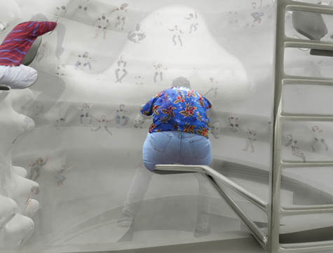 [Image: From Art Trap by Minsuk Cho].
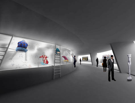
 [Images: From Art Trap by Minsuk Cho].
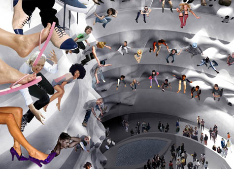 [Image: From Art Trap by Minsuk Cho].
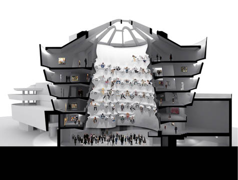 [Images: From Art Trap by Minsuk Cho].
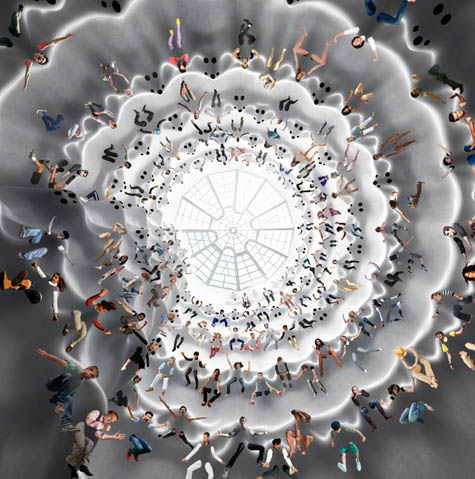 [Image: From Art Trap by Minsuk Cho].
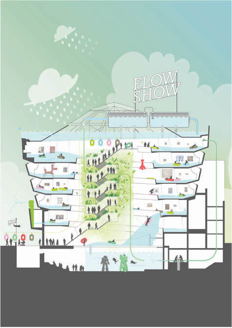 [Image: Flow Show by
 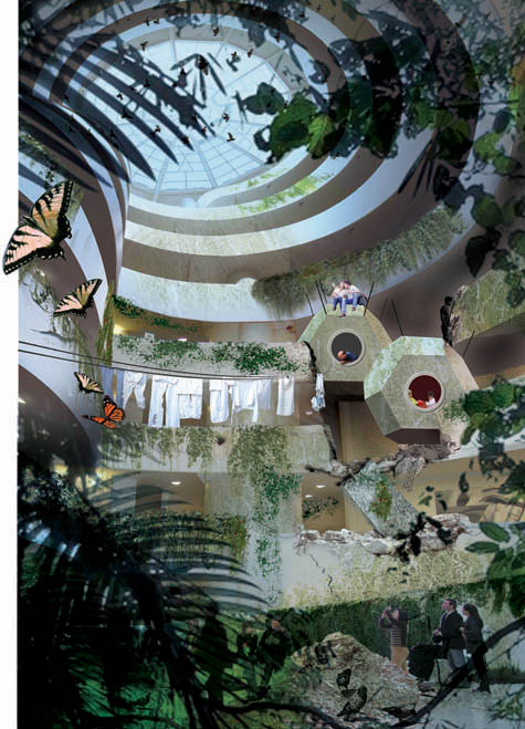 [Image: Untitled by
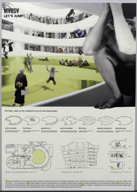
 [Images: (top) Let's Jump! by
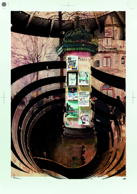
 [Images: (top) Morris in Guggenheim by
 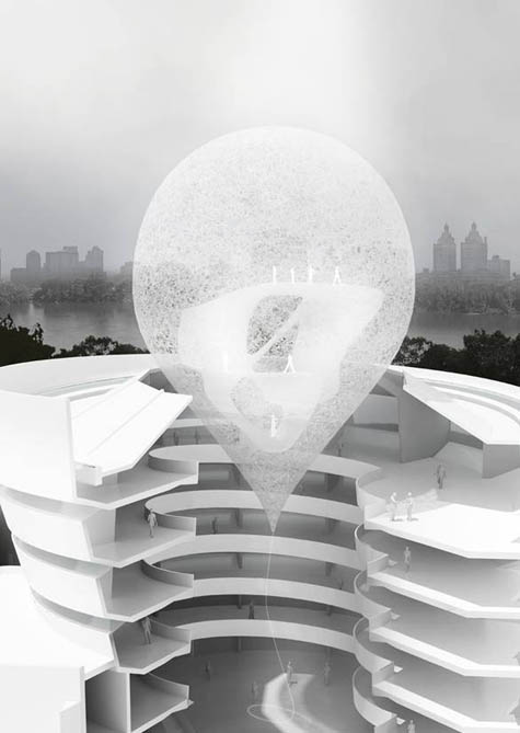 [Image: State Fair Guggenheim by
 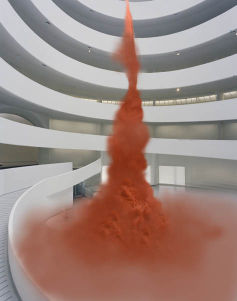 [Image: Untitled by
  [Image: A poster for
 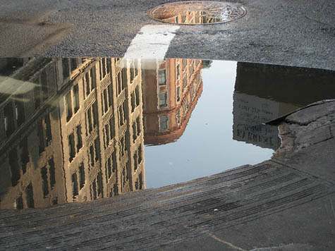 [Image: Photo by Flickr-user
 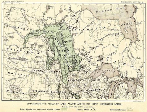 [Image: A map of glacial
 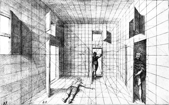 [Image: Perspective by
  [Images: Two diagrams stitched together showing acoustics of bat echolocation at
 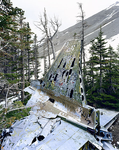 [Image: "C-47 Alberta" by
 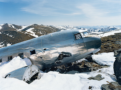 [Image: "C-47 Yukon" by
 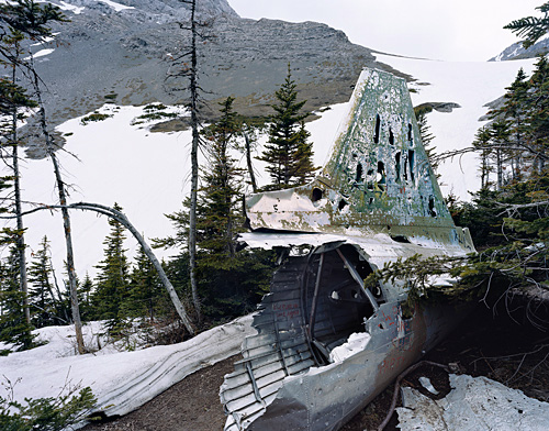 [Image: "C-47 Crows Nest Pass" by
 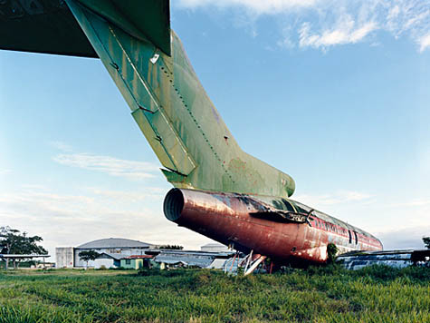 [Image: "727 Santa Domingo" by
 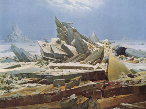 [Image: Das Eismeer (1823-24) by
 [Images: (top) "C-47 Beaver Creek" and (bottom) "C-47 Snag" by
 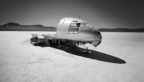 [Image: "Curtiss Commando Patagonia" by
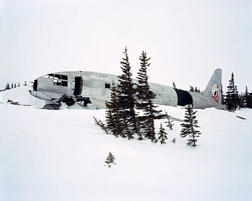
 [Images: "Miss Piggy Churchill" 1 and 2 by
 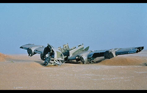 [Image: From
 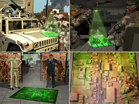 [Images: All images courtesy of
 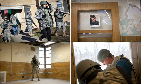 [Images: Inside
  [Image: The Burj Dubai, photographed by Karim Sahib for the
  [Image: "
 [Image: "
 [Image: "
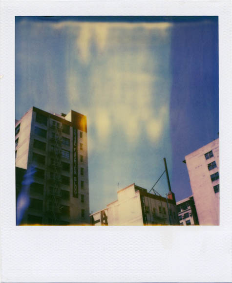 [Image: "
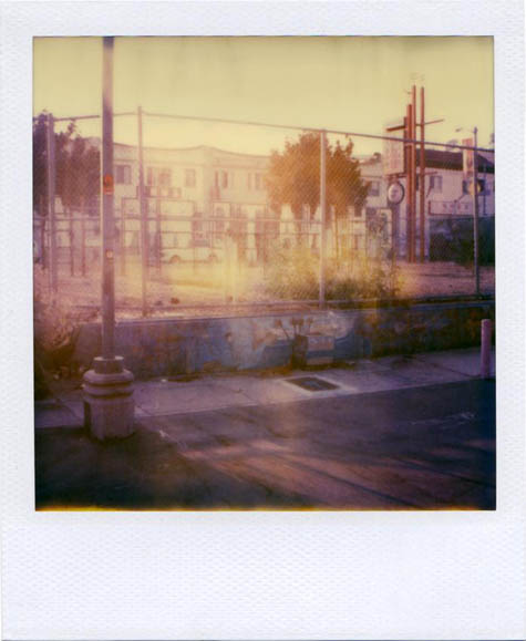 [Image: "
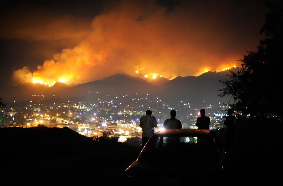 [Image: "A group of young men watch the
  [Images: Three photos by
 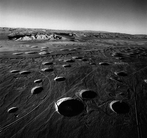 [Image: A photo of subsidence craters, the spatial aftermath of underground nuclear tests, taken by
 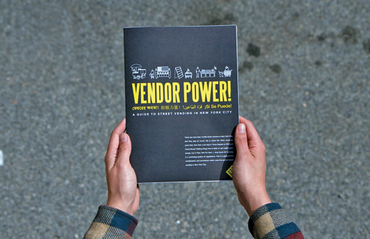 [Image:
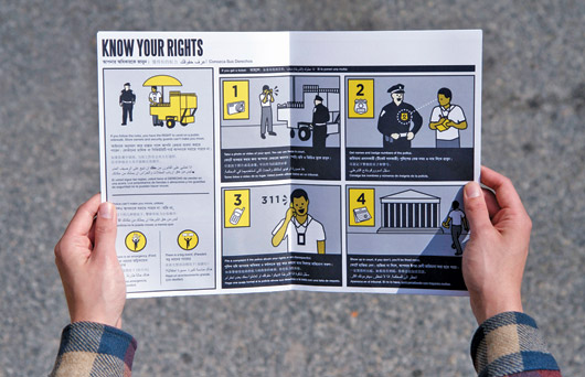
 [Images: Two views of
 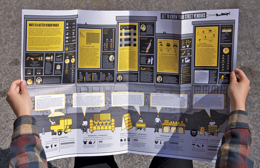 [Image: From
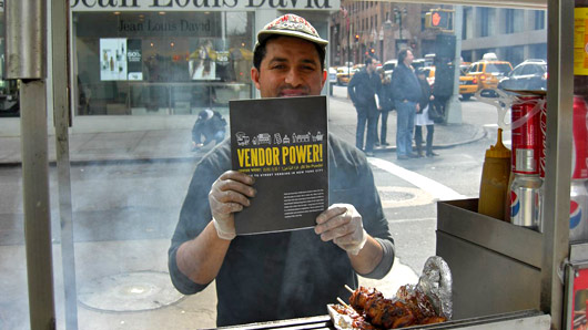
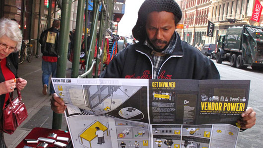
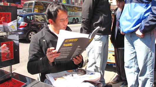
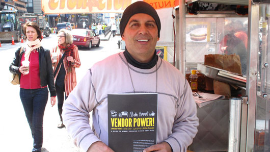 [Images: Vendors reading


