
Buy a Map
 [Image: Photo by Barney Peterson, courtesy of the San Francisco Chronicle].
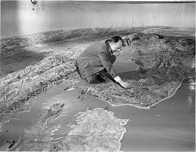
Something I meant to post three few weeks ago, before October became the Great Lost Month of constant busyness and over-commitment, is the story of a 70-ton relief map of California, unseen by the public for half a century, that has been re-discovered in San Francisco, sitting in "an undisclosed location on the city's waterfront."
 [Image: Photo by Barney Peterson, courtesy of the San Francisco Chronicle].
In its time, the map was considered far too marvelous for simply cutting up and storing—but that's exactly what's happened to it.
- It was as long as two football fields and showed California in all its splendor, from Oregon to Mexico, with snow-capped mountains, national parks, redwood forests, a glorious coastline, orchards and miniature cities basking in the sun. It was made of plaster, wire, paint, and bits of rock and sand. In the summer of 1924, Scientific American magazine said it was the largest map in the world.
And, today, it's not going anywhere: "The Port of San Francisco has no plans to be anything but stewards of its storage, and no one else has come forward in half a century to rescue the map." If you have half-a-million dollars or so, and heavy moving equipment at your disposal, then perhaps it could soon be yours.
(Thanks to Steve Silberman for the link. In the archives: San Francisco Bay Hydrological Model; Buy a Torpedo-Testing Facility, Buy a Fort, Buy a Church, and Buy a Silk Mill].


Comments are moderated.
If it's not spam, it will appear here shortly!
Found this post linked via Tumblr.
I found a photo of this map my Grandpa took back in the 1930s while on shore leave (I assume). Somewhat blurry and ravaged by time but it's easy to tell it's the same relief map, the little signs are there and everything.
Thanks, Alex!
I've got a strong hunch that the "undisclosed location" is either pier 15 or 17 on the San Francisco waterfront which is currently being prepared for its new tenant, the Exploratorium
Post a Comment