Back in January 2008, a ship called Tara unlocked from the polar ice near Greenland; it had been frozen in the Arctic floes for a year and four months, repeating the journey of the Fram, a Norwegian ship that once drifted across the polar seas, frozen solid in the ice fields, back in 1896.
In both cases, the ships temporarily became buildings, works of architecture wed flush with the landscape surrounding them.
Visitors to the North Pole in the past 15 months might have happened upon a peculiar sight: a ship, high and dry on the ice pack, her masts upright against the flaming aurora borealis, her bow pointing over the ice sheet, as if sailing on a sea of snow. They might have thought it a polar mirage.
It was, however, the Tara, a mobile building of the Arctic.
In a description so strange I have trouble visualizing it, we read about a "pressure ridge" that moved toward the boat at "super-slow" speeds, threatening everyone on board with destruction:
There was another scare that winter with a “pressure ridge” caused by colliding plates of ice advancing towards the boat. “It was like a frozen wave, moving in super-slow motion—about a centimeter a second,” said [a crew member]. “At one stage we attacked it with picks and chainsaws, but there was no way we could stop it.” It leant over the boat, then suddenly it stopped by itself and “we were released from the pinch,” said [the crew member].
When landscapes attack.
[Image: Map of the Arctic ice routes that brought ships across the sea, courtesy of New Scientist].
But what interests me here is the idea that you could build one thing—a ship—that only becomes what it's really meant to be—a building—when the circumstances it's surrounded by undergo a phase change (here, water turning into ice).
The ship's hull was specifically designed for this, we read in New Scientist; it was "broad, smooth and round so that, rather than being crushed like an egg, the boat would pop up like an olive stone squeezed between finger and thumb, and sit on top of the pack ice. It also featured a lifting centerboard instead of a fixed keel, and removable propellers and rudders. These precautions worked: Tara suffered just a small dent at the stern, and another stretching a metre or so along the hull."
What might the atmospheric equivalent of this be? Perhaps a planetary probe dropped into the skies of Titan or Enceladus, awaiting some strange aerial phase change to occur on all sides?
And, speaking of other planets, could you ever encounter such extraordinary air pressure—on a gas giant, say—such that solid objects simply become trapped in place, unable to fall any further? The atmosphere beneath them is denser than the metal they are made from.
Like machine-fossils buried transparently in air—or like Arctic ships locked in ice—NASA probes would gradually decay, compressed by nothing but air, under deformational pressures lasting tens of millions of years. Aerial tectonics. Slow weather. Sky glacier.
Nicola Twilley and Sarah Rich will be hosting Foodprint NYC later today at Studio-X in Manhattan (the event is free and located at 180 Varick Street, Suite 1610; here is a map).
Things kick off at 1pm, as you can see on the Foodprint Project website.
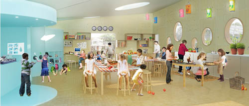
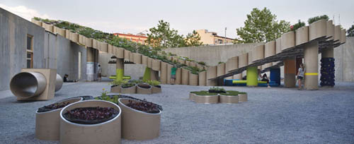
The above images, meanwhile, come from the Edible Schoolyard by WORKac. Amale Andraos, co-principal with Dan Wood in WORKac, will be speaking on a panel at 4:30pm today about her firm's work with nutritional landscapes, educational agriculture, and the future of urban food production.
Edible Schoolyard, specifically, presents "a series of interlinked sustainable systems that produce energy and heat, collect rainwater, process compost and sort waste with an off-grid infrastructure."
At the heart of the project is the Kitchen Classroom, where up to thirty students can prepare and enjoy meals together. The kitchen’s butterfly-shaped roof channels rain water for reclamation. Connected to one side is the Mobile Greenhouse, extending the growing season by covering 1600sf of soil in the colder months and sliding away in the spring, over the Kitchen Classroom. On the other side is the Systems Wall: a series of spaces that include a cistern, space for composting and waste-sorting, solar batteries, dishwashing facilities, a tool shed and a chicken coop.
The project, created in collaboration with Alice Water's Chez Panisse Foundation and P.S. 216, continues the suite of ideas WORKac first explored in their design for Public Farm 1, less a functioning farm, or even a prototype for one, than an intensely spatial art installation ornamented by edible plants.
Joining Amale Andraos on the panel today will be Marcelo Coelho (of "Cornucopia" fame, a 3D food-printer designed with Amit Zoran), Natalie Jeremijenko (of, among many, many other things, the Cross Species Cookbook), and Beverly Tepper (Professor of Food Science at Rutgers and director of the Sensory Evaluation Laboratory). As Edible Geography describes it, "the result will be a speculative and wide-ranging conversation about food security, sensory design, and [the panelists'] hopes and fears for the future of food in New York City."
That is only the final of four panels; read more about today's event over on the Foodprint Project website.
In light of this week's ongoing conversation, I thought I'd take a quick look at how to build a glacier.
The "art of glacier growing," as New Scientist calls it, is "also known as glacial grafting." It has been "practiced for centuries in the mountains of the Hindu Kush and Karakorum ranges," and it was never about science fiction: "It was developed as a way to improve water supplies to villages in valleys where glacial meltwater tended to run out before the end of the growing season."
The artificial glacier, then, is simply a traditional landscape-architectural technique that manipulates and amplifies pre-existing natural processes. It is vernacular hydrology writ large.
First, you need a site, and that site should be mountainous; altitudes higher than 4,500 meters are thermally preferable. From New Scientist:
Once the site is selected, ice is brought to rocky areas where there are small boulders about 25 centimeters across. The rocks protect the ice from sunlight, and often have ice trapped in the gaps between them. This seems to be critical to a successful "planting."
Also critical is the glacier's "gender." Yes, glaciers "have a gender": "A 'male' glacier is one that is covered in stones and soil and moves slowly or not at all. A 'female' one is whiter, and grows more quickly, yielding more water."
After [glacier-growing mountain villagers] have added female to the male ice (traditionally by importing 12 man-loads or about 300 kilograms of the stuff), they cover the area with charcoal, sawdust, wheat husk, nutshells or pieces of cloth to insulate it. Gourds of water placed among the ice and rocks are also critical to a glacier’s chances of forming, according to [artificial-glacier expert, Ingvar Tveiten]. As the glacier grows and squeezes the gourds, they burst, spreading water on the surrounding ice, which then freezes.
Awesomely, the glacier then exhibits complex internal ventilation:
Any snowmelt trapped in the budding glacier also freezes, adding more ice. Pockets of cold air moving between the rocks and ice keep the glacier cool. When the mass of rock and ice is heavy enough, it begins to creep downhill, forming a self-sustaining glacier within four years or so.
Of course, "what’s produced is hardly a glacier in the proper sense," we're reminded, "but growing and flowing areas of ice many tens of meters long have been reported at the sites of earlier grafts."
Let me repeat that: to call these artificial glaciers is a poetic over-statement, as they are much more realistically described as artificially maintained deposits of snow—what I have elsewhere called non-electrical ice reserves. But the thermally self-sustaining nature of these deposits nonetheless makes them susceptible to glaciological analysis.
But there are also other, equally lo-fi techniques of glacier-growing.
Elsewhere, we read that "a good artificial glacier costs $50,000," even though "the materials are simple: dirt, pipes, rocks—and runoff from real glaciers high above." Importantly, then, but quite obviously, a controlled act of artificial glaciation can only be achieved in regions where there is already water available; you can't simply snap your fingers and "build a glacier" in a Tucson parking lot.
Water from an existing stream is diverted using iron pipes to a comparably shady part of the valley and here the water is allowed to flow out onto an inclined mountainside. At regular intervals along the slope of the mountain, small embankments of stone are made which impede the flow of water making shallow pools. At the start of winter, water is allowed to flow into this `masonry contraption' and as the winter temperatures are constantly falling the water freezes forming a thick sheet of ice looking almost like a thin, long glacier.
All this is done before the onset of winter. During the winter, as temperatures fall steadily, the water collected in the small pools freezes. Once this cycle has been repeated over many weeks, a thick sheet of ice forms, resembling a long, thin glacier.
Again: resembling a long, thin glacier. We're not talking about monumental, mountain-crushing tectonic formations (yet)—even if I do feel compelled to wax speculative here and suggest that, if these structures do indeed begin "to creep downhill, forming a self-sustaining glacier within four years or so," then it is not at all unrealistic to assume that, given the right thermal circumstances and the necessary amount of snowfall, you could kick-start glaciation on a macro-scale. This might only mean on the scale of one valley—and not, say, the entire northern hemisphere—but it is an amazing idea that architects could set massive, self-sustaining, tectonically complex structures of ice into motion.
After all, glaciers are very long events, as mammoth memorably put it.
To reiterate the simplicity of this latter design process, I want to quote artificial-glacier expert Chawang Norphel, from an interview he did with the IPS:
Glacier melt at different altitudes is diverted to the shaded side of the hill, facing the north, where the winter sun is blocked by a ridge or a mountain slope. At the start of winter (November), the diverted water is made to flow onto the sloping hill face through appropriately designed distribution channels or outlets.
At regular intervals stone embankments are built, which impede the flow of water, making shallow pools. In the distributing chambers, 1.5-inch diameter G pipes are installed after every five feet for proper distribution of water.
Water flows in small quantities and at low velocity through the G pipes, and freezes instantly. The process of ice formation continues for three to four winter months and a huge reserve of ice accumulates on the mountain slope, aptly termed “artificial glacier.”
I emphasize this for two reasons: 1) It's extraordinarily easy to dismiss the idea of building "artificial glaciers" simply on the basis of the phrase alone. That is, the very phrase "artificial glaciers" sounds pseudo-scientific, impossibly complex, and disastrously fossil-fuel dependent. However, it's actually a remarkably straight-forward design process, involving thermal site-specificity and vernacular building materials. 2) The idea of "artificial glaciers" also reeks of space-operatic self-indulgence, but the fundamental purpose of these structures is to create a reliable freshwater reservoir (or ice reserve) for rural communities.
We're not talking about nuclear-powered snow-blowers built and operated by Darth Vader, in other words; we're talking about rural Himalayan villagers who have learned to reorganize their region's existing snowpack so as to make it thermally self-sustaining.
Or, as Norphel himself phrases it, "Apart from solving the irrigation problem, the artificial glaciers help in the recharging of ground water and rejuvenation of springs. They enable farmers to harvest two crops in a year, help in developing pastures for cattle rearing and reducing water sharing disputes among the farmers."
Having said that, the design possibilities become truly amazing when you scale this up, from a vernacular aid project to the level of carefully-maintained industrial infrastructure, and when you consider a wide range of alternative reasons for stockpiling ice (and, of course, things go bonkers if you let yourself consider genuinely and deliberately sci-fi-inflected ideas, such as maintaining artificial glaciers at the lunar south pole or using artificial glaciation as a Martian terraforming technique).
In any and all cases here, this makes artificial glaciers a fascinating topic for an architectural design studio—at least in my opinion—and the resulting conversations (and even open disagreements) about this topic have been very much worth the time already.
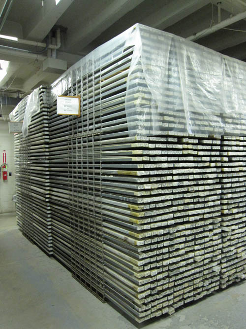
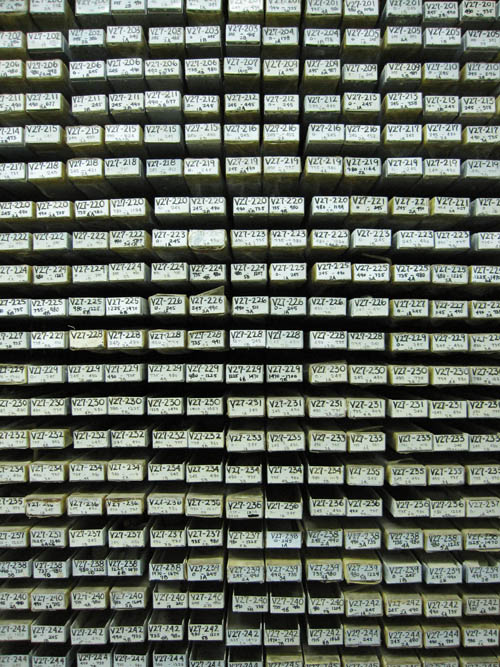
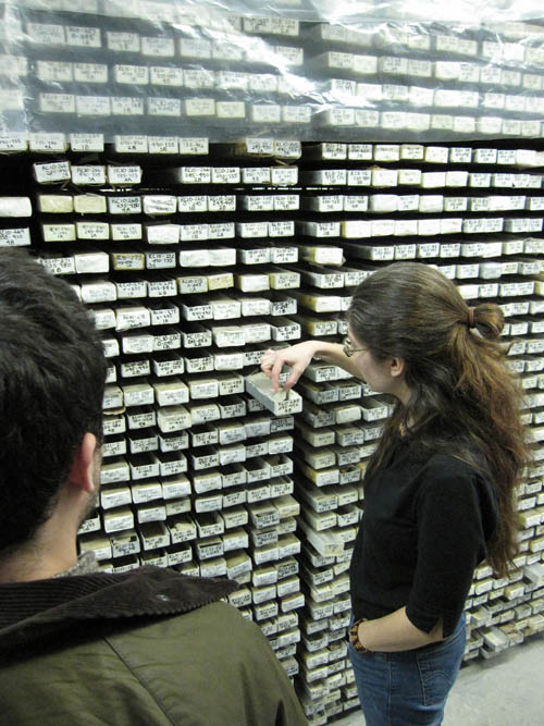
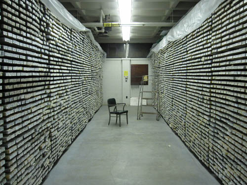
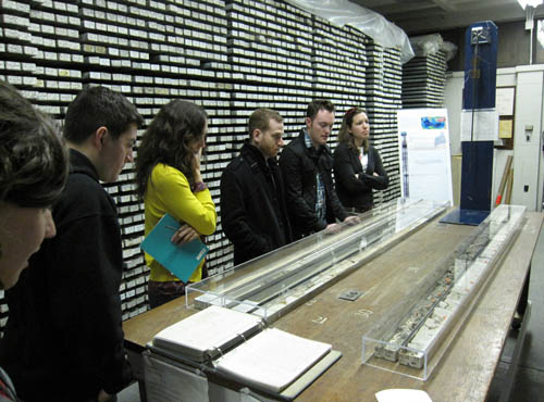
The other day I took my students up to the Lamont-Doherty Earth Observatory for an afternoon of tours through the awe-inspiring Core Lab and for a visit with the Borehole Group; we stopped in at the Lamont-Doherty seismic research station along the way, where we watched our technician-guide create artificial earthquakes with a wooden mallet so that we could watch his digital equipment go to work. It was a great day.
[Images: Inside the Core Lab at Columbia's Lamont-Doherty Earth Observatory].
While we were in the Core Lab, however (photographs of which you see above), our guide mentioned that many of the older core samples—where a coring device is dropped all the way to the seabed in order to take a large cylindrical sample of geological material back to the surface for archiving and analysis—were taken not from ships but from icebergs.
These mobile islands of ice would be temporarily repurposed, turned into science labs at sea. Researchers would simply ride them till they melted, often quite far south into the waters of the North Atlantic.
I had forgotten about this. Oddly, I have been meaning to post about an old ice island called Drift Station Bravo, used for exactly these sorts of purposes, since the earliest days of BLDGBLOG (in fact, I mentioned Drift Station Bravo in a very old interview with Ballardian).
In light of the Glacier/Island/Storm studio, then, and after our inspiring tour of Lamont-Doherty, I thought I'd briefly recount this awesome story.
[Image: Drift Station Bravo postage cancellation mark, via Polar Philately].
As explained by the Polar Philately page, Colonel Joseph O. Fletcher, commander of an Air Force weather squadron stationed in the Arctic, discovered "a large tabular iceberg... that had broken off the Arctic ice shelf... [and] gone adrift."
This island of solid ice was soon "codenamed T-1, taken from its original radar designation as a target." Future "ice islands" were codenamed T-2 and T-3.
On March 19, 1952, the U.S. Air Force led by Colonel Fletcher and some scientists landed on this ice island [T-3] in a C-47 aircraft, setting up a weather observation station. Fletcher established a research station that was manned at this big ice sheet for roughly the next 25 years, despite a grim quote given by the head of the Alaska Air Command at the time, a General Old, who was quoted in a Life magazine article of the time as saying "I don't see how any man can live on this thing."
These details seem worth repeating: Fletcher's weather station was operated on a repurposed but naturally occuring ice island for 25 years.
Fletcher's Ice Island, and the research station that was located on it, rotated in circles in the Arctic Ocean, floating aimlessly along in the Arctic currents in a clockwise direction. The station was inhabited mainly by scientists along with a few military crewmen and was resupplied during its existence primarily by military planes operating from Barrow, Alaska.
Even better, the island—later renamed "Drift Station Bravo"—was inhabited long enough that it actually got its own postal network.
[Image: Letters postmarked from Drift Station Bravo, via Polar Philately].
During the period of active habitation, T-3 covers [basically postage stamps] were serviced, each stamped with a variety of hand-stamped cachets and markings, dated, and often marked with a manuscript notation of the geographic position of the drifting station on that particular day of ops. The T-3/Bravo covers were often cancelled at Barrow or at a USAF base in Alaska, and then placed in the mailstream.
The envelope, in other words, was stamped with the latitude and longitude of the iceberg at the moment of that letter's departure.
[Image: A postal marking from Drift Station Bravo, via Polar Philately].
Over on InfraNet Lab, we read that ice "has been a strategic building material in the Arctic for the construction of roads, airstrips, housing, and, in the last few decades, as temporary drilling platforms to explore for oil."
Ice islands are formed by spraying ice into cold air (below 20 degrees F), and layering the ice until it reaches a thickened state. These islands are either grounded at the bottom of the sea floor or are floating structures in deeper waters. Fabricated in just two months, these islands provide enough stability to support exploratory drilling tools including the rig and attendant equipment.
One of many amazing things about Drift Station Bravo, however, is that it was an administratively claimed piece of naturally existing, mobile territory. It wasn't created in any genuine architectural sense, simply redirected, named, and given its own postal identity.
Given this act of territorial appropriation, and bearing in mind the island's fundamental state of mobility, what are the implications for its maritime jurisdiction, as Enrique Ramirez explores over on a456?
[Image: A letter from Drift Station Bravo, via Polar Philately].
This becomes a question of immediate geopolitical concern when we consider the fact that Drift Station Bravo and its ilk were actually created in a Sputnik-like reaction to the Soviet's own very active ice island program. The Soviets "already operated six drifting ice camps of this kind," we read in a documentary transcript, downloadable as a 27kb PDF, but, "owing to the particular strategic importance and sensitivity of the Arctic Basin, little information from these early Soviet stations had reached the West."
That same transcript goes on to explain exactly how the U.S managed to architecturally colonize these nomadic ice worlds. Like a vision straight out of Archigram, military civilization on the ice established itself as follows:
...a ski-equipped C-47 landed on the ice and deployed the first team of workers. It included an Air Force Major as camp commander and several soldiers with technical skills who had volunteered for 6 months duty on the ice, plus four of the typical tough and versatile Alaskan construction workers.
Modular buildings, called Jamesway huts, camp supplies, fuels, two small World War II Studebaker tractors, called Weasel, and a small bulldozer, were dropped by parachutes.
I could quote the entire PDF, in fact, as it is easily one of the most fascinating things I've read, but a particularly eye-popping detail comes when we read that these researchers deliberately generated earthquakes in the iceberg they lived on: "we generated tiny earthquakes in the ice. The propagation of the compressional waves generated in this way are used to study the elastic properties of the ice."
The story expands rapidly from here. In an article originally published in the September-October 1966 issue of Air University Review, we read that competitive Soviet drift stations apparently discovered a "second magnetic north pole... located near 80° N and 178° W, with magnetic medians extending across the Arctic Ocean," and that sulfuric gas fumes from a badly timed undersea volcanic eruption killed at least one unlucky crew member.
The whole thing amazes me, in fact. I don't know why I've been sitting on this story for so long, but it's nice, finally, to put something up about Drift Station Bravo. How many other icebergs actually had their own postal codes?
(I owe a huge thanks to the Lamont-Doherty Earth Observatory staff for taking my students around their facilities—we had a great time. Thanks!)
[Image: "Drawing shows ice island, frozen by liquid air, proposed by German scientist as a floating harbor and landing field"; via InfraNet Lab].
InfraNet Lab's new post on artificial ice islands—and the architectural use of ice as a building material for things like roads, drilling platforms, remote airstrips, and more—is absolutely fascinating and a must-read. Don't miss it.
By way of a quick update, several fantastic new posts have joined this week's ongoing series of linked conversations, part of the Glacier/Island/Storm studio at Columbia's GSAPP.
[Image: Map showing a straight baseline separating internal waters from zones of maritime jurisdiction; via a456].
Here is a complete list so far, featuring the most recent posts and going backward in temporal order from there [note: this list has been updated as of February 26]. By all means, feel free to jump in with comments on any of them:
—Nick Sowers of UC-Berkeley/Archinect School Blog Project on "Super/Typhoon/Wall"
Finally, I was excited to see that Ethel Baraona Pohl and César Reyes Nájera have jumped into the conversation, adding their own thoughts over at dpr-barcelona; and Alexander Trevi of Pruned has also supplied a Glacier/Island/Storm-themed guide to his own archives in this hashtag switchboard. And that's in addition to some ongoing posts here on BLDGBLOG.
It's been a great week for new content, I think, and all of the above are worth reading in full.
Continuing, briefly, with the ideas presented in the previous post, I wanted to add two more things:
1) Could ancient astronomical events also have been recorded in architectural ornament (not just in paintings or poetry)? In other words, somewhere beneath the overgrown vines of some Indiana Jones-like complex in the Cambodian rain forest—or carved into the solid rock of a minor cathedral near Dijon—is a bas-relief depicting a star gone nova six hundred years ago. This astral disaster left no other record than that. Previously unknown celestial events could thus be pieced together through stone carvings found as far apart as a village church in Russia and a temple on the Deccan Plateau—or even stars in stained glass windows. So is there an architectural equivalent to the appearance of Halley's Comet's in the Bayeux Tapestry? A previously unknown meteor shower historically recorded in a chapel's stone vault?
2) What about epidemiological history as recorded in architectural ornament? Of course, there are already dozens of examples of medical historians determining, through close readings and reinterpretations of literary document, that such and such a king or character must have been suffering from syphilis or a brain tumor or lead-induced dementia. But I'm specifically interested here in how medical symptoms might have taken on ornamental form. Perhaps, in the writhing Gothic forms of church facades—in those old carved faces depicting humans hybridized with angels and demons, plants and animals, minerals and gods—we might yet discover the symptomological clues of some horrifying medieval plague or outbreak. You travel to a remote mountain village in Macedonia to study vernacular church-building traditions only to find a shunned building on the edge of town whose ornamentation borders on the grotesque—and you soon realize that you've discovered not just an architectural masterpiece but evidence of a forgotten disease, similar to Ebola, that had otherwise gone unrecorded. At the very least, this would make for an awesome potboiler or short novel, that I would absolutely love to write (attention, publishers!).
My point, though, is to ask if there are any real-world examples of architectural ornament in which something like an unknown astronomical event, or a disease forgotten by the modern world (weird bodies on a stone frieze in northern India). If so, how might these strange carving be subject to the same type of analysis as explored in the previous post?
I sense a new historical field here—called ornamental forensics—just waiting to happen.
[Image: Perseids Meteor Shower, August 11, 1999; photo by Wally Pacholka, courtesy of NASA].
In an earlier post, I looked at the possibility that the paintings of Vincent Van Gogh might include a very physical archive of 19th-century meteorological events, with sand, dust, pollen, and other airborne particulates from the days Van Gogh painted en plein air now trapped for all art history inside the vibrant swirls of his canvases.
Adam, from Design Under Sky, then left a comment saying that this unintentional archive of sand already exists, with or without such speculation: "Sand was used as an ink blotting material and remnants are often still found in manuscripts today." Every library is thus also a museum of sand.
But I completely failed to mention an article that has fascinated me for more than a year now; I believe I originally found it via Andrew Ray of Some landscapes.
In a feature for COSMOS Magazine called "Sky detectives," we read that "forensic astronomers... are seeking clues to historical events embedded in artworks and literature."
[Image: Halley's Comet—upper right—passes through the Bayeux Tapestry].
In other words, similar to the idea of geomythology—in which ancient tales of floods or vengeful fire gods can be re-interpreted in light of newly found evidence for catastrophic tsunamis or volcanic eruptions—"forensic astronomers" look for more celestial clues. Things like Halley's Comet burning through the night sky of the Bayeux Tapestry will catch their eye, or supernovas as depicted in Native American rock art.
These details, hidden in plain sight, can be used to indirectly piece together long-gone astronomical events.
The following very long quotation gives at least some idea of how extraordinary the results can be; it's like something out of Minority Report:
Donald Olson, a physics professor at Texas State University in San Marcos, U.S., has used similar techniques to help art historians pin down details of famous paintings. In 2000, for example, he found the location at which Vincent van Gogh created one of his last paintings, The White House at Night.
Knowing that van Gogh painted it in mid-June, and the direction in which the house faced, Olson was able to determine that a bright star in the painting was mostly likely the planet Venus, which would have been prominent at the time.
Two years later, Olson used a similar process with another van Gogh painting, Moonrise. That painting depicts the full moon rising behind an overhanging cliff in southern France. Historians knew the work was made sometime in 1889, and haystacks in the foreground indicate that the time of year is somewhere around harvest season.
Olson's team hunted down the location and, with a bit of astronomical detective work, determined that there was only one date on which the Moon rose in the right place: 13 July 1889. Since van Gogh once said he never worked from memory and always painted what he saw, this was probably the date on which he started painting Moonrise.
Here, I'll reveal a secret fantasy of mine: at one point during the film Jaws, there is a night scene during which a meteor suddenly lights up the sky overhead. The characters are out at sea when zoooooom: a flash goes by, from one end of the screen to the other.
Every time I see that scene I wonder what the flash was, and, more importantly, where it went: if something later crashed down into the sands of North Africa, or hit a cliff in Arizona, or splashed into the ocean waters much further out at sea. Or simply burnt up into dust and fiery particles.
[Image: Rock art possibly depicting a supernova. Photo by John Barentine, Apache Point Observatory, courtesy of SPACE.com].
But what if someday you find a meteorite and you somehow piece together evidence for when it fell to earth—and you find that it was during the summer that Steven Spielberg filmed Jaws. You find out exactly where they filmed Jaws, and you keep digging deeper, and then, finally, there it is: some fantastic piece of irrefutable evidence that proves you have just discovered the very object that once flew through the sky in a film seen by countless millions of people around the world. Jaws, after all, is the seventh-highest grossing film of all time.
It's archaeo-astronomy via Hollywood film history.
In any case, as you will see in the "Sky detectives" article, our forensic astronomers begin reading nothing less than The Odyssey, looking for astronomical clues ("...the poem describes Odysseus steering his boat by the positions of the constellations Boötes and the Pleiades [which] establishes the date as early spring...").
But as they start putting Homer's descriptions of the constellations, and the precise order and time of year in which Odysseus saw those constellations, into their weird software that maps the movement of the earth and our nearby planets through 49,000 years of history... my hair began standing on end.
All these astronomical clues—in ancient poetry, famous paintings, and the overlooked skies of film history—simply waiting to be deciphered.
The interview discusses urban food-distribution networks, the cultural and nutritional effects of food-vendor carts, the geographic distance from "farm to table," food-contamination scares, what Sarah describes as "the ways in which food and eating behaviors influence the physical shape of the city," Nicola's interest in "cupcake shops as indicators of gentrification," and much more. Be sure to check it out in full—and consider coming to the event on Saturday.
Architect David Garcia's MAP project—the Manual of Architectural Possibilities—has been mentioned here before, which makes me all the more excited to announce that the next issue of MAP will not only be themed around quarantine but it will be on display as an offical part of the Landscapes of Quarantine exhibition opening next month at Storefront for Art and Architecture.
This installment, which features Garcia's speculative designs for projects like a "Zoo of Infectious Species," a "Domestic Isolation Unit," and an "Instantly Quarantinable Farm," will also once again include an introductory text by Sir Peter Cook.
Garcia will in town for Storefront's Landscapes of Quarantine opening party, on Tuesday, March 9, so be sure to come by, buy a copy of MAP 002: Quarantine for yourself, and meet the man in person.
Tim Maly of Quiet Babylon and Nicola Twilley of Edible Geography have both jumped into the Glacier/Island/Storm blogathon unfolding this week with posts about, respectively, questions of island sovereignty, national borders, data havens, geo-preservation and more, and, at Edible Geography, specialty ices developed for the boutique cocktail trade.
Tim's post—which you should read in full—brings to mind recent moves by the Australian government to "excise" distant islands so as to prevent illegal immigrants from reaching what would otherwise legally recognized as Australian land.
The whole legislative exercise falls somewhere between a managed retreat of territorial sovereignty and a particularly Kafka-esque interpretation of Zeno's paradox.
In Kafka's short story "A Message from the Emperor," for instance, we read that an imperial messenger, instructed to deliver the dying emperor's final wish to a recipient far away, finds himself unable to travel anywhere at all. Indeed, as he struggles to make his way through endless crowds and palace antechambers, fighting his way toward a destination that was, at best, unclear, "how futile are all his efforts," we read.
He is still forcing his way through the private rooms of the innermost palace. Never will he win his way through. And if he did manage that, nothing would have been achieved. He would have to fight his way down the steps, and, if he managed to do that, nothing would have been achieved. He would have to stride through the courtyards, and after the courtyards through the second palace encircling the first, and, then again, through stairs and courtyards, and then, once again, a palace, and so on for thousands of years.
Now reverse this. Imagine someone—a subject of the empire—trying to force his or her way back to the center, trying against overwhelming odds to reach the very epicenter of sovereign power, but utterly unable to succeed.
There is always another courtyard to cross; always more rooms to run through.
Now imagine this being played out on a South Pacific archipelago, where you are up against a sovereign state that insists on "excising" bits and bobs of its outer territory in order to sabotage your own best efforts to get somewhere. You step onto one island, secure in what you think is arrival, only to be told that, no, this is not yet Australia. You are both here and not here. This island is us—but it is also something we have legally abandoned.
So you move on to the next island—and the next, and the next.
The territorial complexities of sovereign governance thus rapidly spiral into clouds of uncertainty.
According to The Age, an Australian newspaper, "the Howard government removed about 4,600 islands from the migration zone in 2005, preventing boat people who land there from accessing Australian law and claiming asylum in Australia." The "migration zone" referred to here includes Christmas Island, which now—in 2010—falls into a strange grey zone of legality; from the perspective of an arriving immigrant, it both is and is not Australia.
This is what architect Ed Keller might call the political science fiction of excised island terrain.
I'm reminded of China Miéville's recent novel The City & The City, in which differently controlled but spatially overlapping urban territories have been marbled into and through one another; you can physically stand in two cities at once, yet only legally be present in one at any given time.
Now blow Miéville's strange in-and-out status up to the scale of a South Pacific archipelago and you have something approximating the spatial logic of Australian territorial law as applied to commonly used immigration routes.
Read the actual, island-excising Parliamentary documentation here.
Nicola Twilley, meanwhile, studies "detailed instructions for artificial glacier construction," suggesting that "vernacular Himalayan glacier grafting techniques" might actually "have the potential to revolutionize the cocktails of tomorrow."
In other words, artificial glaciers grown and maintained by specialty cocktail bars could be produced to order, made to include "orchid flowers, raspberries, or espresso beans," Nicola writes, thus creating "flavor-accented glaciers." These could then be chopped down into "berry-studded chunks," rough cubes that supply "the perfect finishing touch for a Brownie Cognac or Irish coffee."
"The theatrical potential of custom artificial glaciers," she jokes, "might be second only to the champagne fountain."
These are only the two most recent posts in a week full of linked conversations exploring the Glacier/Island/Storm studio at Columbia University. Here is a list of those relevant posts, if you're interested:
One of many books I've been referring to quite often these days, both in personal conversations and during desk-crits with my students, is Michael Welland's Sand, newly released in paperback.
I'll be mentioning many things from his book throughout the coming days and later; for now, I simply want to call attention to a comment Welland makes about Vincent Van Gogh's habit of painting en plein air—that is, outside, with fresh paint, in the windswept meadows and fields near the Mediterranean, where dust storms were an expected part of an afternoon.
This regional meteorology often resulted in sand grains being blown onto Van Gogh's still-wet canvases—and thus becoming a permanent part of art history.
Indeed, in some cases, Welland writes, citing Van Gogh's own letters, the sand could get so dense and accumulate so thickly that he would have to scrape preliminary images from the unfinished canvas and start again. That intrusive terrestrial presence—pieces of the very thing his paintings were meant to represent—was thus removed.
More interestingly, though, passing meteorological events of the 19th century left behind what we might call aerial fossils: traces of violent wind patterns and minor climatologies that have been frozen into place on the surface of plein air paintings.
The result is a kind of storm archive—an unintentional core sample of 19th-century weather—housed in museums around the world. Squint long enough, perhaps, and beneath those swirling mists and pixelations you will see traces of the Sahara, of building dust, of pollen, of the wheat-sprouting soil of the region, all recorded for good measure through time.
Like some unexpected variation on Jurassic Park—in which it is not the DNA of dinosaurs extracted from ancient amber that we use to reconstitute a missing being—perhaps an army of art historians and scientists, equipped with microscopes and tweezers, could pull from the surface of every painting by Vincent Van Gogh a catalog of lost weather systems, mapping the moving sands of his era.
[Image: "Reykjavik Botanical Garden" by Andrew Corrigan and John Carr].
In a fantastic issue of AD, edited by Sean Lally and themed around the idea of "Energies," a long list of projects appeared that are of direct relevance to the Glacier/Island/Stormstudio thread developing this week. I want to mention just two of those projects here.
[Image: "Reykjavik Botanical Garden" by Andrew Corrigan and John Carr].
For their "Reykjavik Botanical Garden," Rice University architecture students Andrew Corrigan and John Carr proposed tapping that city's geothermal energy to create "microclimates for varied plant growth."
"Heat is taken directly from the ground," they write, "and piped up across the landscape into a system of [pipes and] towers."
Zones of heat radiate out from the pipes, creating a new climate layer with variable conditions based on their number and proximity to each other. These exterior plantings are mostly native to Iceland, but the amplified environment allows a wider range of growth than would normally be possible, informing the role and opportunity of this particular botanical garden. Visitors experience growth never before possible in Iceland, and travel through new climates throughout the site.
Amidst "hydroponic growing trays and research laboratories," and sprouting in the climatic shadow of complicated "air-intake systems," a new landscape grows, absorbing its heat from below.
[Image: "Reykjavik Botanical Garden" by Andrew Corrigan and John Carr].
The climate of the city is altered, in other words, literally from the ground up; using the functional equivalent of terrestrially powered ovens, otherwise botanically impossible species can healthily take root.
This domestication of geothermal energy, and the use of it for purposes other than electricity-generation, raises the fascinating possibility that heat itself, if carefully and specifically redirected, can utterly transform urban space.
[Image: Produced for the "Vatnsmyri Urban Planning Competition" by Sean Lally, Andrew Corrigan, and Paul Kweton of WEATHERS].
A variant on this forms the basic idea behind Sean Lally's own project, produced with Andrew Corrigan and Paul Kweton, for the Vatnsmyri Urban Planning Competition (a competition previously discussed on BLDGBLOG here).
Their design also proposes using geothermal heat in Reykjavik "to affect the local climatic conditions on land, including air temperature and soil temperature for vegetative growth." But their goal is to generate a "climatic 'wash'"—that is, an amorphous zone of heat that lies just slightly outside of direct regulation. This slow leaking of heat into the city could then effect a linked series of hot zones—or variable microclimates, as the architects write—that would punctuate the city with thermal oases.
Like a winterized inversion of the air-conditioned cold fronts we feel rolling out from the open doors of buildings all summer long, this would be pure heat—and its attendant humidity—roiling upward from the Earth itself. The result would be to generate a new architecture not of walls and buildings but of temperature thresholds and bodily sensation.
Indeed, as David Gissen suggests in his excellent book Subnature, this project could very well imply "a new form of urban planning," one in which sculpted zones of thermal energy take precedence over architecturally designated public spaces.
Of course, whether this simply means that under-designed urban dead zones—like the otherwise sorely needed pedestrian parks now scattered up and down Broadway—will be left as is, provided they are heated from below by a subway grate, remains, for the time being, undetermined.
This is all just part of a much larger question: how we "renegotiate the relationship between architecture and weather," as Jürgen Mayer H. and Neeraj Bhatia, editors of the recent book -arium: Weather + Architecture, describe it. The Glacier/Island/Storm studio will continue to explore these and other abstract questions of climate and architectural design throughout the spring.
[Image: Glacier-protection services in the Swiss Alps; photo by Olivier Maire/Epa/Corbis, via the Guardian].
Several posts in our Glacier/Island/Stormblog week are already up and working it:
Nick Sowers, Design to Fail: In which we read about tree-bombing Guam, the unintended reuse of abandoned military artifacts, global climate change as national security threat, and how all architects should plan for the failure of their most grandiose ideas.
InfraNet Lab, LandFab, or Manufacturing Terrain: In which we read about "volcanic heroism," desert islands, "politically anomalous artificial land fabrication," and a brief history of dredging in the Florida Everglades (perhaps vaguely related: Prosthetic Delta).
mammoth, a glacier is a very long event: In which we read about the self-altering internal torque of metamorphic glaciers, salt farms, shell middens, the ecological redesign of an abandoned landfill, accretionary geographies, and much more.
The title of this post, meanwhile, comes from mammoth, as cited above. It was also chosen as way of pointing out that, while this week pretends toward the status of symposium—that is, multiple blogs with different backgrounds all pursuing a shared suite of themes and references at the same time for a limited period—it is, in reality, no more than what already happens in the deep chains of internet conversation everyday. I write a post referring to something on Pruned; Pruned perhaps saw something tweeted by Ballardian or Alexis Madrigal; the link in question might have come from the New York Times or even Metafilter; and the endlessly marbled laminations of successive re-linking never cease to accumulate. That's how things are; that's simply what happens. This is thus just an amplification of processes that already occur.
(There may or may not be Twitter updates throughout the week using the #glacierislandstorm hashtag, as well).
[Image: From Modern Mechanix, thanks to a tip from Nicole Seekely].
For the next five days, if everything goes as planned, BLDGBLOG and eight other architecture, design, and technology blogs will be engaged in a series of linked posts and ongoing conversations about themes relevant to the "Glacier/Island/Storm" studio at Columbia University this Spring.
For my own part, I'll be posting on a wide range of themes directly related to the studio, including summaries of visiting expert lectures and class field trips to local scientific institutions; but I will also be offering my own speculative thoughts on the matter. Also, in addition to each blogger commenting on one another's posts when possible, or simply following up with their own response-posts, I will be maintaining a list of relevant links to keep the whole thing flowing.
So my students and I are off on a field trip for the rest of the day, but I will begin putting up posts this evening. Feel free to join in, leave comments, suggest further readings, and more. Thanks!
A mind-bogglingly awesome new project from MIT called Flyfire hopes to use large, precision-controlled clouds of micro-helicopters, each carrying a color-coordinated LED, to create massive, three-dimensional information displays in space.
Each helicopter is "a smart pixel," we read. "Through precisely controlled movements, the helicopters perform elaborate and synchronized motions and form an elastic display surface for any desired scenario." Emergency streetlights, future TV, avant-garde rural entertainment, and even acts of war.
Watch the video:
Instead of a drive-in cinema, in other words, you could simply be looking out from the windscreen of your car at a massive cloud of color-coordinated, precision-timed, drone micro-helicopters, each the size and function of a pixel. Imagine planetarium shows with this thing!
The Flyfire canvas can transform itself from one shape to another or morph a two-dimensional photographic image into an articulated shape. The pixels are physically engaged in transitioning images from one state to another, which allows the Flyfire canvas to demonstrate a spatially animated viewing experience.
Imagine web-browsing through literal clouds of small flying pixels, parting and weaving in the air in front of you like fireflies (or imagine training fireflies to act as a web browser). You're in a university auditorium one day when, instead of delivering her projected slideshow, your professor simply remote-controls a whirring vortex of ten thousand flying micro-dots. Digital 3D cinema is nothing compared to this murmuration of light.
Channeling Tim Maly, we might even someday see a drone-swarm of LED-augmented, artificially intelligent nano-helicopters flying off into the desert skies of the American southwest, on cinematic migration routes blurring overhead. On a lonely car drive through northern Arizona when a film-cloud flies by...
An insane emperor entertains himself watching precision-controlled image-clouds, some of which are distant satellites falling synchronized through space.
[Image: The Cornucopia Digital Fabricator, "a personal, three-dimensional printer for food," by Marcelo Coelho and Amit Zoran; Coelho will be speaking this Saturday at Foodprint NYC].
1)Foodprint NYC is this Saturday, February 27, at Studio-X in New York City: "Foodprint NYC is the first in a series of international conversations about food and the city. From a cluster analysis of bodega inventories to the cultural impact of the ice-box, and from food deserts to peak phosphorus, panelists will examine the hidden corsetry that gives shape to urban foodscapes, and collaboratively speculate on how to feed New York in the future. The free afternoon program will include designers, policy-makers, flavor scientists, culinary historians, food retailers, and others, for a wide-ranging discussion of New York’s food systems, past and present, as well as opportunities to transform our edible landscape through technology, architecture, legislation, and education." It is free and open to the public, and the speaker line-up is amazing. The whole thing goes from 1-5:30pm. Here is a map. Foodprint NYC is organized by Nicola Twilley and Sarah Rich.
2) Here is a great design competition: "Currently, over 100,000 people each year follow informal trails through wetlands and over active train tracks to gain access to the surf breaks at Trestles," we read. "These impromptu manmade paths present a safety hazard with passing trains and threaten the fragile ecosystem of Trestles."
In response, a coalition of concerned groups organized by the volunteer non-profit organization Architecture for Humanity, are launching “Safe Trestles,” an open-to-all, two-stage design competition to create a safe pathway to serve surfers, the local coastal community and day visitors to San Onofre State Beach. This coalition is looking for cohesive designs that eliminate the danger of crossing active train tracks, help to restore wetlands that have been damaged by the present path, preserve and improve vistas, and offer education about the history of the site and the beach marsh environment.
Registration deadline: March 17, 2010; submission deadline: April 17, 2010
3)workAC's 49 Cities exhibition travels to San Francisco next month, where it opens at the San Francisco Planning and Urban Research Association (SPUR. "A survey of utopian urbanism, 49 Cities provides a remarkable insight into the contemporary metropolis and our efforts over time to make cities more controllable, monumental, organic, taller, denser, sparser or greener." A newly expanded reprint of the accompanying 49 Cities book, published by Storefront for Art and Architecture, will be for available for purchase. Amale Andraos, principal architect (with Dan Wood) of workAC will be speaking at Foodprint NYC.
6)Coastlines: Images of Land and Sea opens at the Dallas Museum of Art on April 25, 2010. The exhibition explores "how modern and contemporary artists—from Childe Hassam and Edward Hopper to Willem De Kooning, Gerhard Richter and Catherine Opie—have drawn upon coastal landscapes as a source of inspiration, metaphor and mystery in their work. Through selections from the Museum’s rich collections and important local holdings, Coastlines: Images of Land and Sea will juxtapose coastal landscapes from around the world and from a range of different artistic traditions."
7)Pruned supplies his newest list of quick links—and they're all worth reading: Prunings LIII. In particular, don't miss the $100 million, seven-story aquarium being planned for Times Square: a Canadian developer hopes to "install tanks featuring sharks, rays, penguins, otters, and other animals in the bottom floors of the 40-story building, known as 11 Times Square, hoping to attract some of the 35 million people who pass through Manhattan's major crossroads every year."
8) The new issue of Vague Terrain has been released; its theme is Architecture/Action. "Where is the boundary that separates space from computation?" the issue asks. "What is this territory that lies between interaction design, gaming, physical computing, and architecture?"
9) Speaking of computation, Unconventional Computing & Architecture will be held this Friday, February 26, at the Building Centre in London. "This one-day conference explores new materials for architectural practice in the 21st century. International architects and scientists will explore the decision-making properties of matter and how this may be applied to create increasingly life-like buildings."
10)Built for the Bush is now on display in the Australian city of Albury, showcasing "green architecture for rural Australia." The exhibition "explores some of the energy efficient features of Australia's 19th century country homes and the reappearance of many of these traditional practices in contemporary green architecture."
And one to grow on: Alberto Pérez-Gómez will be speaking tomorrow night, Tuesday, February 23, in the Great Hall of New York City's Cooper Union. His talk—"The Splendor of Architectural Shadows in a Nihilistic Age"—is free and begins at 6:30pm.
BLDGBLOG ("building blog") is written by Geoff Manaugh. The opinions expressed here are my own; they do not reflect the views of my friends, editors, employers, publishers, or colleagues, with whom this blog is not affiliated. More.

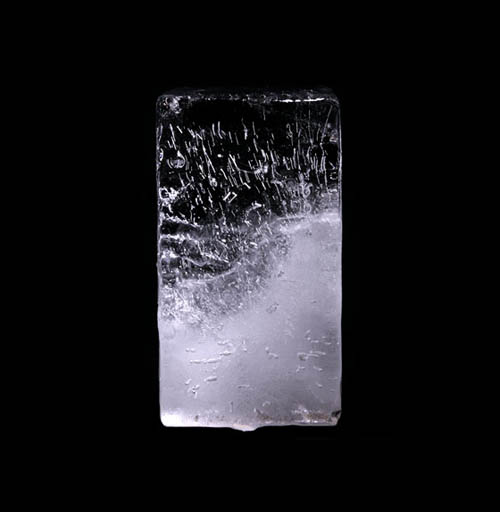
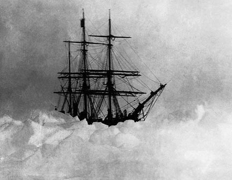 [Image: Trapped in ice].
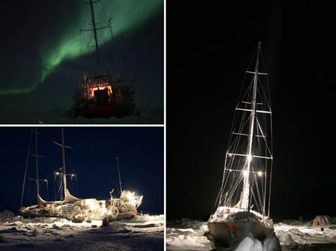 [Images: Photos via Jules Verne Adventures].
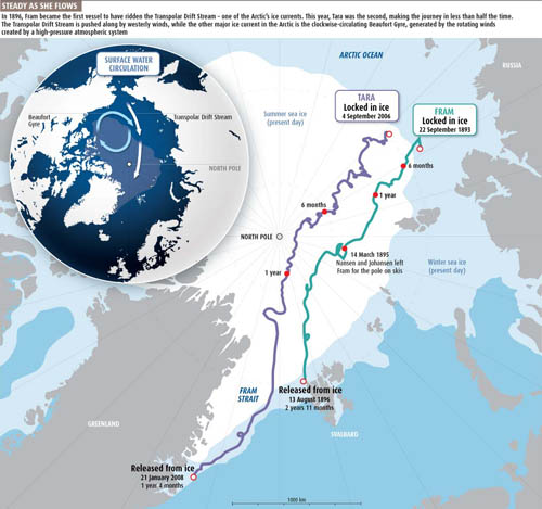 [Image: Map of the Arctic ice routes that brought ships across the sea, courtesy of New Scientist].
 [Image:
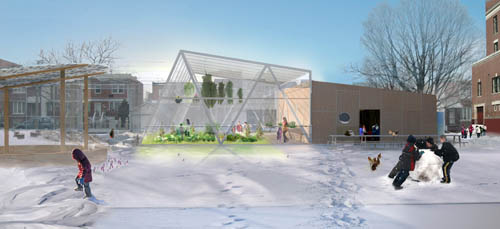
 [Images:
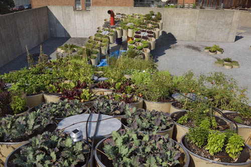
 [Image:
  [Image: From Wired Science's photo gallery, "
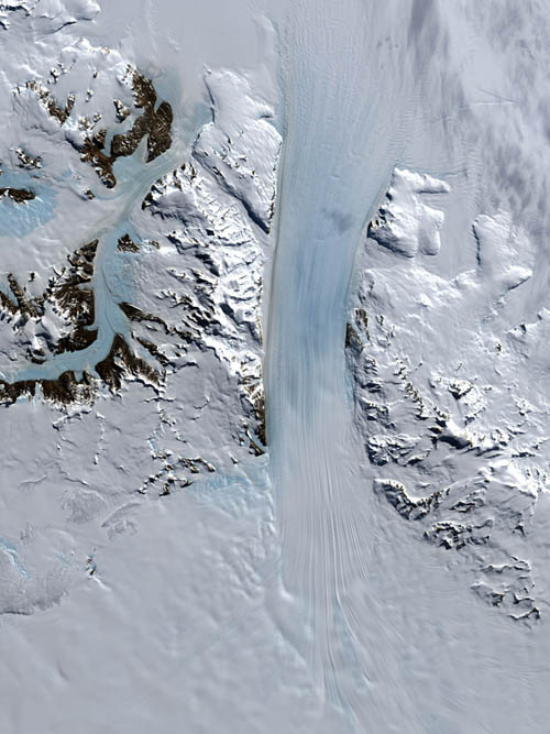 [Image: From Wired Science's photo gallery, "
 [Image: From Wired Science's photo gallery, "
 [Image: From Wired Science's photo gallery, "
 [Image: From Wired Science's photo gallery, "
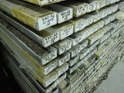
 [Images: Inside the
  [Image: Drift Station Bravo postage cancellation mark, via
 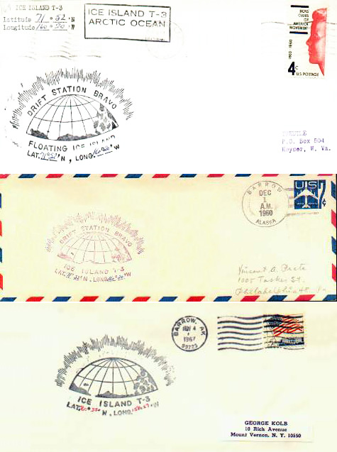 [Image: Letters postmarked from Drift Station Bravo, via
 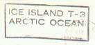 [Image: A postal marking from Drift Station Bravo, via
  [Image: A letter from Drift Station Bravo, via
 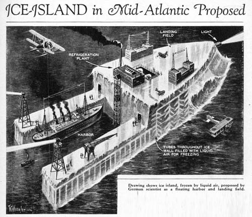 [Image: "Drawing shows ice island, frozen by liquid air, proposed by German scientist as a floating harbor and landing field"; via
 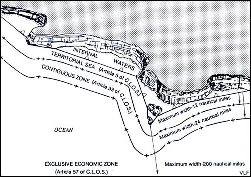 [Image: Map showing a straight baseline separating internal waters from zones of maritime jurisdiction; via
  [Image: Photo by Andy Marshall of
  [Image: Perseids Meteor Shower, August 11, 1999; photo by Wally Pacholka, courtesy of
  [Image: Halley's Comet—upper right—passes through the
  [Image: Rock art possibly depicting a supernova. Photo by John Barentine, Apache Point Observatory, courtesy of
  [Image: Courtesy of Flickr-user
 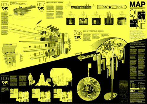 [Image:
 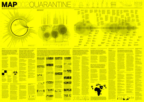 [Image:
 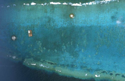 [Image: The Okinotori Islands—or
 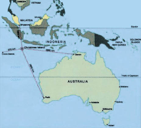 [Image: Map of
  [Image: Photo by
 [Images: Photos by
  [Image: Vincent Van Gogh, "
 [Image: Vincent Van Gogh, "
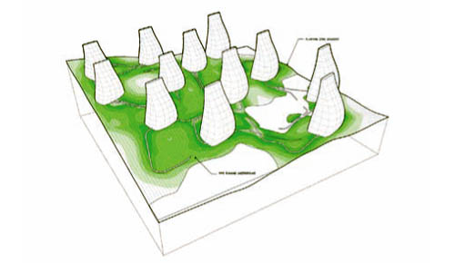 [Image: "Reykjavik Botanical Garden" by Andrew Corrigan and John Carr].
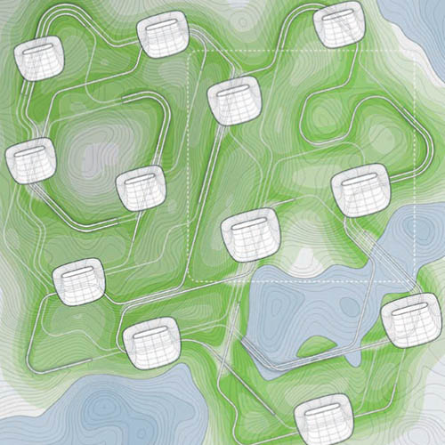 [Image: "Reykjavik Botanical Garden" by Andrew Corrigan and John Carr].
 [Image: "Reykjavik Botanical Garden" by Andrew Corrigan and John Carr].
 [Image: Produced for the "Vatnsmyri Urban Planning Competition" by Sean Lally, Andrew Corrigan, and Paul Kweton of
  [Image: Glacier-protection services in the Swiss Alps; photo by Olivier Maire/Epa/Corbis, via the
 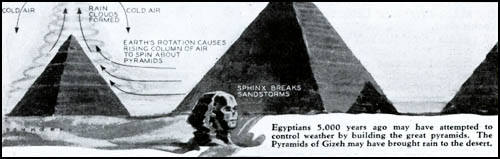 [Image: From
  [Image: From
  [Image: Via
  [Image: The
  [Images: From 49 Cities by
  [Images: From
  [Image: Unknown image, via
  [Image: Unknown image, via


